Weather
New MA Storm Coming: Snow Timing, Flood Watch, Wind Threat
On top of up to 6 inches of snow, Massachusetts will be under a flood watch and a wind advisory during a Wednesday storm.

MASSACHUSETTS — A new, messy storm will hit Massachusetts Wednesday, bringing snow and the threat of local flooding, damaging winds and freezing rain.
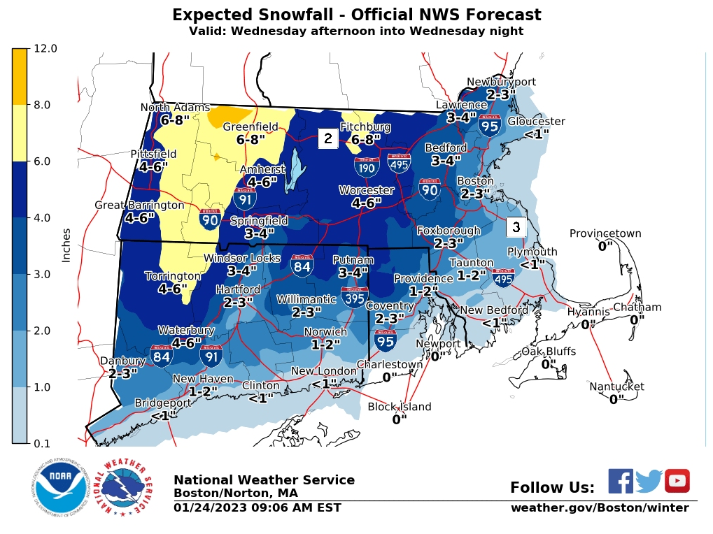
The new storm system will sweep across Massachusetts starting around noon Wednesday, dropping as much as 6 more inches of snow in some areas, according to the National Weather Service. The storm will also bring potentially high winds to the state, with a wind advisory in effect for the Cape and South Shore.
Heavier snow will be concentrated north and west of Worcester with between 4 and 6 inches predicted. But areas farther east like Boston and the North Shore could see 2 to 3 inches. The storm will offer a "front end punch," according to the weather service, with more snow at the beginning of the storm on Wednesday evening before a transition to rain.
Find out what's happening in Across Massachusettsfor free with the latest updates from Patch.
As of Tuesday night, school districts including Framingham, Worcester and Auburn had all announced early closures for Wednesday afternoon.
Snow will begin rolling into Worcester around 2 p.m., according to the weather service. The entire state will be seeing snow by 8 p.m. with small pockets of freezing rain moving from west to east through the late night hours.
Find out what's happening in Across Massachusettsfor free with the latest updates from Patch.
All of Worcester County and Middlesex County from Hopkinton to near Lawrence will be under a winter weather advisory watch for the 12 hours starting Wednesday at 1 p.m. Anywhere from 4 to 7 inches might fall in the area north of Worcester north and west along the New Hampshire and Vermont borders.
"Heavy snow possible. Total snow accumulations of 4 to 7 inches possible. Winds could gust as high as 35 mph," the storm watch bulletin said.
The snow will change to rain beginning around 6 p.m. near Cape Cod, according to forecasts. That transition will continue heading north with the entire state getting rain by midnight.
The weather service also issued a flood watch Tuesday afternoon for Cape Cod, the South Shore, the Boston area and almost all of Norfolk County. The flood watch also covers all of Rhode Island.
"A period of heavy rain combined with snowmelt Wednesday night into Thursday morning may cause street and poor drainage flooding along with rises on area rivers, creeks and streams. Localized flooding also will be favored where heavy rain falls on clogged storm drains," the weather service said.
Get more local news delivered straight to your inbox. Sign up for free Patch newsletters and alerts.