Weather
Powerful Coastal Storm Trends Tropical, Targets MA For Weekend: See Latest Forecast
Significant coastal erosion, 60 MPH winds, and heavy rain are possible during the potential three-day impact.


Warnings of significant beach erosion, flooding and storm damage from winds up to 60+ miles per hour grew louder on Wednesday as the chances of a powerful, three-day coastal storm slamming into New England became higher.
AccuWeather said a strong Gulf Stream influence could turn the storm, which had been forecast as a potential nor'easter, into more of a subtropical system.
"If that occurs, the storm could be assigned a name by the National Hurricane Center," said AccuWeather chief meteorologist Jonathan Porter.
Find out what's happening in Across Massachusettsfor free with the latest updates from Patch.
A persistent east and northeast wind has already churned up the coast along Massachusetts, with wind and pounding surf capable of taking a major toll on beaches this weekend. The impact will be enhanced by astronomical high tides associated with a full moon.
.png)
AccuWeather said heavy rainfall could lead to flooding, especially in low-lying and poor-drainage areas. Strong winds could down trees, and lead to localized and more regional power outages.
Find out what's happening in Across Massachusettsfor free with the latest updates from Patch.
"Parts of southern New England, especially near the South Coast, have been particularly wet over the past 30 days, with some locations receiving 150 to 200% of their historical average rainfall. The wet ground increases the risk of trees toppling in wind gusts of 50 to 60 mph," Porter said. "Many trees still have their leaves, which catch more wind and place additional strain on their roots, further increasing the risk for trees to come down and may also increase the number of power outages as compared to similar storms."
AccuWeather on Wednesday forecast widespread rainfall totals of 1 to 2 inches across New England, with up to 4 to 8 inches possible along the South Shore, South Coast and the Cape and Islands.
Wind gusts could reach 60+ mph with the storm expected to begin late on Friday and last into Monday.
The National Weather Service forecast waves of 15 to 20 feet during the storm after already being 10 to 15 earlier this week.
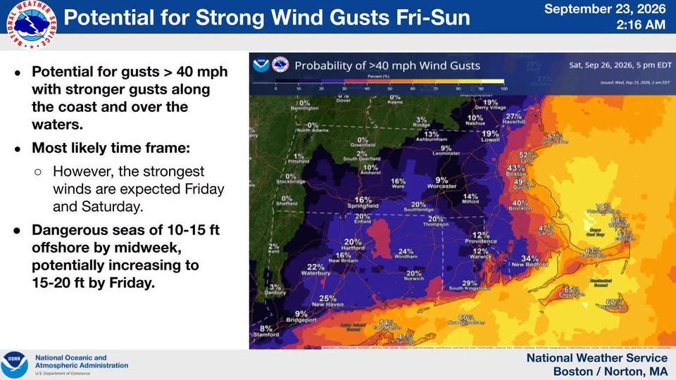
The NWS already issued a Coastal Flood Watch for Friday and Saturday.
"The exact time for an approaching low-pressure system remains uncertain," the NWS said. "That will become important for peak surge around the times of high tides. Multiple tide cycles will be impacted, which combined with strong onshore flow may result in tides not lowering as well."
The NWS said beach erosion will be of particular concern on east-facing beaches.
Latest Forecast (National Weather Service):
Wednesday Night
Mostly clear, with a low around 52. Northeast wind 9 to 16 mph.
Thursday
Mostly sunny, with a high near 62. Northeast wind 13 to 17 mph.
Thursday Night
Mostly cloudy, with a low around 52. Northeast wind 9 to 13 mph.
Friday
A chance of showers, mainly after 10 a.m. Mostly cloudy, with a high near 62. Breezy, with a northeast wind 16 to 21 mph, with gusts as high as 34 mph. Chance of precipitation is 30%. New precipitation amounts between a tenth and quarter of an inch possible.
Friday Night
Showers likely, mainly after midnight. Cloudy, with a low around 54. Breezy, with a northeast wind 17 to 20 mph, with gusts as high as 33 mph. Chance of precipitation is 60%.
Saturday
Showers likely and possibly a thunderstorm. Mostly cloudy, with a high near 61. Breezy, with a north wind 20 to 22 mph, with gusts as high as 38 mph. Chance of precipitation is 70%.
Saturday Night
Showers likely, with thunderstorms also possible after 2am. Mostly cloudy, with a low around 55. Breezy, with a north wind around 23 mph, with gusts as high as 37 mph. Chance of precipitation is 70%.
Sunday
Showers likely and possibly a thunderstorm. Mostly cloudy, with a high near 62. Breezy, with a north wind around 23 mph, with gusts as high as 34 mph. Chance of precipitation is 70%.
Sunday Night
Showers likely. The rain could be heavy at times. Mostly cloudy, with a low around 55. North wind 15 to 17 mph, with gusts as high as 31 mph. Chance of precipitation is 70%.
Monday
A chance of showers. Mostly cloudy, with a high near 62. North wind 13 to 16 mph. Chance of precipitation is 50%.
Monday Night
Mostly cloudy, with a low around 54. North wind around 7 mph.
Tuesday
Mostly sunny, with a high near 65. Northwest wind around 7 mph becoming northeast in the afternoon.
Tuesday Night
Partly cloudy, with a low around 55. Light and variable wind.
Wednesday
Mostly sunny, with a high near 68. Light and variable wind becoming southeast 5 to 7 mph in the morning.
Get more local news delivered straight to your inbox. Sign up for free Patch newsletters and alerts.