Weather
Slushy Snowstorm Socks Parts Of MA: Check Out Latest Snow Totals
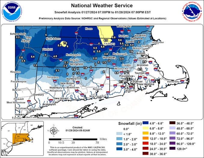
Totals ranged widely across the state with more than 8 inches in some areas and little-to-no accumulation along the coast.


MASSACHUSETTS — Sunday night and the early Monday morning commute was either a snowy blast or a slushy nuisance across Massachusetts depending on your location amid the latest winter storm.
While some areas of Worcester County and far northwestern Middlesex County received up to 8 inches of snow and more, most areas in and around Greater Boston were closer to 1 or 2 inches that came through later in the storm and had a hard time sticking to roads with temperatures at or slightly above 32 degrees.
Students in some central Massachusetts cities and towns enjoyed a longer weekend with cancellations and delays plentiful. There were fewer disruptions in eastern Massachusetts with many coming from regional schools that draw students from a wide area.
Find out what's happening in Across Massachusettsfor free with the latest updates from Patch.
Here are some of the totals across the state as of 9 a.m. Monday, according to National Weather Service spotter reports.
8.3 inches — Ashby
Find out what's happening in Across Massachusettsfor free with the latest updates from Patch.
7.7 inches — Ashburnham
7.4 inches — Hawley
6.1 inches — Lunenberg
5.5 inches — Fitchburg
4.4 inches — Tewksbury
3.4 inches — Worcester Airport
0.3 inches — Logan International Airport, Boston
Any remaining snow showers were moving out of the state on Monday morning with the exception of possible ocean-effect snow across the coast that may measure up to an inch.
A Gale Warning remained in effect offshore but the NWS lifted all Winter Storm Watch and Winter Storm Warning alerts across Massachusetts.
Those looking for some quieter winter weather ahead will be happier with this week's forecast as it looks to be cold and blustery on Tuesday with a high of 27 degrees before temperatures moderate to more seasonable temperatures, or slightly above, by late week.
The high on Wednesday is forecast at 39 degrees with partly sunny skies with temperatures hitting 44 on Thursday and 43 on Friday.
The end of the week comes with a chance of light snow showers and a brisk wind that will make it feel colder than the forecast highs in the 30s both Saturday and Sunday.
(Scott Souza is a Patch field editor covering Beverly, Danvers, Marblehead, Peabody, Salem and Swampscott. He can be reached at Scott.Souza@Patch.com. X/Twitter: @Scott_Souza.)
Get more local news delivered straight to your inbox. Sign up for free Patch newsletters and alerts.