Weather
Snow, Sleet, Fierce Wind, Flood Threat Across MA: Wintry Storm Update
A long-duration, January-like storm is headed toward New England. Find out the threats near you.

MASSACHUSETTS — A wintry mix of snow, sleet, heavy rain, fierce winds and possible coastal flooding is headed toward Massachusetts this week with a long-duration storm that will make things feel much more like January than the first week of April.
While it will be a cold rain for most of the state, there will likely be some mixing of snow and sleet north and west of Boston with accumulations possible in northern Worcester County and the Merrimack Valley near the New Hampshire border.
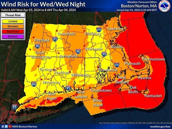
There will also be wind gusts up to 50 miles per hour near coastal locations and flood threats — especially during the Thursday morning high tide.
Find out what's happening in Across Massachusettsfor free with the latest updates from Patch.
The storm is expected to arrive with rain early Tuesday afternoon and last into Friday or Saturday with a chance of snow showers and chilly temperatures for the third week of spring.
According to the National Weather Service, Tuesday night will feature rain across the region with winds off the ocean from the East at 10 to 15 miles per hour.
Find out what's happening in Across Massachusettsfor free with the latest updates from Patch.
Wednesday will be mostly just unpleasant with persistent rain, heavy at times, temperatures hovering around 40 degrees and wind gusts up to 35 miles per hour.
Winds will ramp up Wednesday night with gusts up to 50 miles per hour and temperatures hovering in the 30s in Greater Boston with rain turning to snow and sleet in interior locations. An inch or two of slushy accumulation is possible from Route 128 north and west past Route 495 and 3 inches or more of snow and ice is possible for the higher elevations of Worcester County and far northern Essex County near the New Hampshire border in the Merrimack Valley.
The storm will continue into Thursday with more of the same as a cold rain douses the coast and Greater Boston and more of a wintry mix in north central and western Massachusetts. Interior New Hampshire and Maine locations are likely to see plowable snow with up to 6 to 12 inches possible in the mountains.
Minor coastal flooding is possible during three high tide cycles — especially the one on Thursday morning.
Things will slowly quiet down Thursday night into Friday with chilly temperatures in the 40s and a chance of rain lingering into Friday and early Saturday.
Sunday should see the beginning of a brighter, warmer stretch with temperatures in the 50s heading toward the 60s, and perhaps 70s, next week — including Monday's 93 percent eclipse in Massachusetts with the total eclipse occurring in northern Maine, New Hampshire and Vermont.
Get more local news delivered straight to your inbox. Sign up for free Patch newsletters and alerts.