Weather
MA Weather: Detailed Timeline Of Tuesday Snowstorm
Here is when the storm is expected to start (likely with fast-falling snow) and end (possibly with rain.)


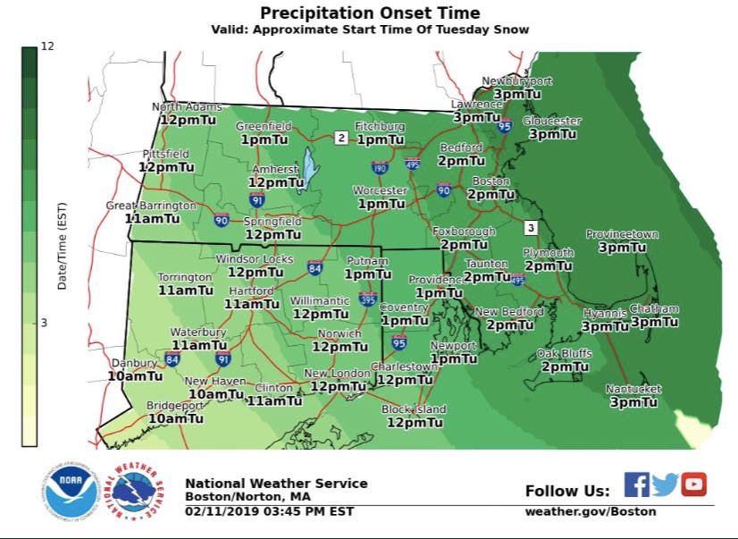
The snowstorm expected to come Tuesday is going have a "significant impact" on the commute home. The National Weather Service Monday evening set an updated timeline for when the fast-falling snow is expected to start.
The storm is expected to enter Massachusetts from the west at 11 a.m., making it's way to Worcester by 1 p.m., getting to Boston by 2 p.m., and reaching the coast shortly after. Snowfall rates are expected to be between 1-2 inches, meaning serious accumulation in a short amount of time.
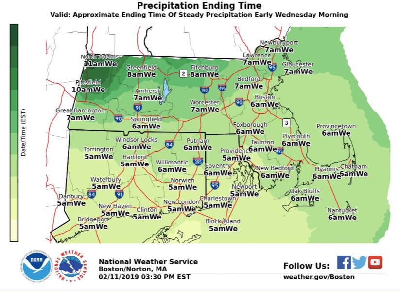
The storm will begin tapering off around 6 a.m. in Boston and 7 a.m. in Worcester. At that point the temperature change could have forced a change to rain. Either way, it'll be a sloppy commute into work.
Find out what's happening in Framinghamfor free with the latest updates from Patch.
[Approximate Tue Snow/Sleet Timeline] Not meant to be exact, but this indicates approximate start time of the snow followed by a change to sleet between Noon and 7 pm. High confidence in a significant impact to the Tue PM commute w/ a brief window of 1-2" per hour snowfall rates. pic.twitter.com/1XuCPlzrns
— NWS Boston (@NWSBoston) February 11, 2019
A winter weather advisory has been issued for all of Massachusetts and it's joined by a winter storm watch in much of the state in advance of some 4-8 inches of snow.
Even if the snow totals disappoint, the wintry precipitation will make for a messy day. The thing to watch for will be the temperature. The precipitation is leaning more toward a snow and wintry mix as of Monday, the National Weather Service said, but "a slight nudge warmer or colder, snow & ice amounts could change."
Find out what's happening in Framinghamfor free with the latest updates from Patch.
The most recent forecasts are calling for 6-8 inches north of the Pike, with 4-6 inches along the Pike and in the Boston area. A wave of snow falling at about an inch per hour will make its way through the state first, followed by a wintry mix and then a transition to rain across Southeastern Mass.

NWS Boston image
Get more local news delivered straight to your inbox. Sign up for free Patch newsletters and alerts.