Weather
'Extreme' Heat Will Feel Like 110+ Degrees, Bring Severe Storm Risk To MA: See Latest Forecast
Temperatures and humidity will build to an near-unbearable peak Wednesday through Friday.

An intense "dome" of heat building over the Midwest through the Mid-Atlantic, Northeast and New England will bring record-high heat and humidity with "feels-like" temperatures of up to 110 degrees for a three-day stretch leading into the holiday weekend.
The tropical onslaught will build from early in the weekend with a high of 90 degrees on Tuesday to 100 degrees or higher on Wednesday, Thursday and Friday.
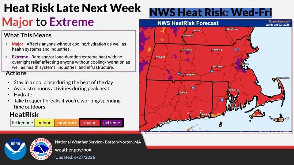
The National Weather Service called the risk "major to extreme" with detrimental effects on anyone without proper hydration or who suffers from health issues, and said that it could "reach lethal temperatures" inside vehicles and other poorly ventilated spaces.
Find out what's happening in Marlboroughfor free with the latest updates from Patch.
The NWS on Monday issued an "Extreme Heat Watch" for all of Massachusetts, except for the Berkshires, Cape Cod and the Islands.
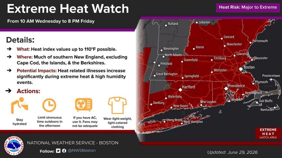
The Extreme Heat Watch, which will likely be upgraded to a Warning by mid-week, begins on Wednesday morning and runs through Friday night.
Find out what's happening in Marlboroughfor free with the latest updates from Patch.
"Drink plenty of fluids, stay in an air-conditioned room, stay out of the sun, and check up on relatives and neighbors," the NWS said. "Do not leave young children and pets in unattended vehicles.
"Car interiors will reach lethal temperatures in a matter of minutes."
The hot weather will also carry with it the potential for severe storms — especially on Tuesday night as the hottest weather arrives and on July 4 as it departs.
The NWS is forecasting a high of 92 degrees on Tuesday, 99 degrees on Wednesday, 103 degrees on Thursday and 99 degrees on Friday.
Those would be record highs for Boston on Wednesday, Thursday and Friday.
Making things even more unbearable for those without air conditioning will be the nighttime low temperatures of 74 degrees on Wednesday night, 79 degrees on Thursday night and 76 degrees on Friday night.
The heat will moderate — carrying with it the chance of storms — over the holiday weekend with a high temperature of 92 degrees on Saturday and 87 degrees on Sunday.
Latest Forecast (National Weather Service):
Monday
Sunny, with a high near 81. East wind 6 to 9 mph.
Monday Night
Mostly clear, with a low around 66. East wind around 5 mph becoming light and variable in the evening.
Tuesday
Increasing clouds and hot, with a high near 92. Southwest wind 5 to 9 mph.
Tuesday Night
A chance of showers before 1 a.m., then a chance of showers and thunderstorms between 1 a.m. and 2 a.m., then showers likely after 2 a.m.
Mostly cloudy, with a low around 71. Southwest wind around 9 mph.
Chance of precipitation is 60%.
Wednesday
A chance of showers before 9 a.m. Mostly sunny and hot, with a high near 99. Southwest wind around 10 mph. Chance of precipitation is 30%.
Wednesday Night
A slight chance of showers before 1 a.m. Partly cloudy, with a low around 76. Southwest wind around 7 mph. Chance of precipitation is 20%.
Thursday
Sunny and hot, with a high near 103. West wind 6 to 9 mph.
Thursday Night
Mostly clear, with a low around 79. West wind around 7 mph.
Friday
A chance of showers after 4 p.m. Mostly sunny and hot, with a high near 99. West wind 7 to 10 mph. Chance of precipitation is 30%.
Friday Night
A chance of showers before 8pm. Partly cloudy, with a low around 74. West wind 3 to 6 mph. Chance of precipitation is 30%.
Independence Day
A chance of showers and thunderstorms. Mostly sunny and hot, with a high near 92. North wind 5 to 8 mph, becoming east in the afternoon. Chance of precipitation is 30%.
Saturday Night
A chance of showers and thunderstorms. Mostly cloudy, with a low around 70. South wind 3 to 6 mph. Chance of precipitation is 30%.
Sunday
Mostly sunny, with a high near 87. Light and variable wind becoming east 5 to 9 mph in the morning.
More on Patch:
Get more local news delivered straight to your inbox. Sign up for free Patch newsletters and alerts.