Politics & Government
Naming the Natick Paths: What Would You Pick?
Officials are considering naming some of the smaller, lesser-known, paths in Natick. Share your ideas for path names.

NATICK, MA -- For hikers and nature lovers, Natick’s got a good share of trails, including the Elsenmenger Trail, and those in Hunnewell Town Forest and Pegan Cove Park.
Now, officials are considering giving some of the smaller, lesser-known trails in Natick identities.
Selectman Josh Ostroff proposed at a December Board of Selectmen meeting the idea to name some of the Natick paths.
Find out what's happening in Natickfor free with the latest updates from Patch.
“Members were interested, but they wanted input from other committees and abutters,” said Ostroff.
Up to 11 paths in Natick would get names if approved.
Find out what's happening in Natickfor free with the latest updates from Patch.
“Safety, navigation, convenience, proper budgeting and to encourage walking are the benefits [of naming them],” said Ostroff. “ There are no drawbacks of which I am aware to the public, but people living nearby may see a drawback if this invites additional use.”
Most of the proposed names are for those paths that adjoin streets or neighborhoods. One proposed name is “Ken Rendell,” who is the founder and director of the Museum of WWII.
“In the case of that path, that is partly across an Eversource right of way,” said Ostroff. “We would need to get their approval to formally obtain an easement, although the path has been used for decades.”
The following are the 11 paths that are being considered for naming:
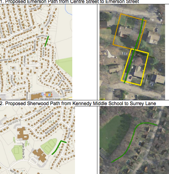
- Between Centre and Emerson Streets in Wethersfield (“Emerson Path”) on easements.
- From Kennedy Middle School to Surrey Lane (“Sherwood Path”); partly on School Committee property, partly on a town layout.
- From Grove Road at Border Road to the Gravel Pit and Morse’s Pond Trail (“Grove Path”). Partly on town layout, partly on Town owned land at the Gravel Pit.
- From Richmond Road to Winslow Road (“Traverse Path”); on the layout for Traverse Road.
- From Oakridge Ave to Bacon Street (“Oakridge Path”); on easements 6. From Arbor Circle to Pauline Drive (“Arbor Path”); partly on an easement and partly over private property subject to a license agreement with the Town.
- From Clearview Drive to Craigie Street (“Little South Path”); on town land under control of the Conservation Commission.
- From Parkview Street to Craigie Street (“Parkview Path”); on a town layout
- From Woodleigh Road to Whispering Lane (“Woodleigh Path”); on easements and a town layout. This includes a bridge paid for by a developer and maintained by the Town.
- From Oliver Street to Pitts Street (“Oliver Path”) on a town layout.
- From Essex Street (off Porter Rd) to Mercer Road (“Rendell Path”); over an Eversource ROW and a privately owned parcel, with town land at either end.
The board has reached out to the Open Space Advisory Committee, the Conservation Commission, Kennedy Middle School and the Safety Committee for feedback, which should be submitted by Jan. 22.
What say you, Natick residents? Do you think the paths need names? If so, what do you propose for a path name? Share in the comments below.
Get more local news delivered straight to your inbox. Sign up for free Patch newsletters and alerts.