Weather
MA Weather: Heat Wave Could Be Historic — And Dangerous
Boston could see its first 100-degree day in eight years, while Worcester could see its first in more than a century.


It's not exactly news that the summer is hot, but this is a bit much. The National Weather Service agrees and issued an excessive heat warning for most of Massachusetts from noon Friday to 8 p.m. Sunday as temperatures tickle triple digits.
Some areas are expected to see their first 100-degree day in years. The last time Boston hit triple digits was July 22, 2011, according to the NWS. Worcester hasn't seen those temperatures since the Fourth of July ... in 1911.
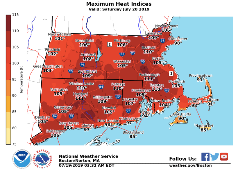
The heat index will reach as high as 112 degrees this weekend, the NWS said. The heat index is how hot it feels when you go outside, even if the temperature is a bit less. Temperatures will range from the mid-90s to the low-100s this weekend.
Find out what's happening in Newtonfor free with the latest updates from Patch.
Friday will be sweltering, but the most oppressive heat will be Saturday and Sunday. You'll want the air conditioner on tonight; overnight temperatures could still be in the 80s.
Temperatures this hot aren't just annoying, they can be dangerous, weather officials warn. People, especially the elderly, can be at higher risk for heat stroke and heat exhaustion during prolonged exposure to outside temperatures. It's suggested people wear light clothing, stay out of the sun, avoid physical exertion, and remain hydrated.
Find out what's happening in Newtonfor free with the latest updates from Patch.

Boston-area forecast via National Weather Service
Today - Mostly sunny, with a high near 91. Southwest wind 3 to 8 mph.
Tonight - Partly cloudy, with a low around 74. West wind 6 to 8 mph.
Saturday - Mostly sunny and hot, with a high near 100. Heat index values as high as 110. West wind 3 to 6 mph.
Saturday Night - Partly cloudy, with a low around 77. West wind 3 to 6 mph.
Sunday - A slight chance of showers and thunderstorms after 3pm. Mostly sunny and hot, with a high near 98. West wind 3 to 6 mph. Chance of precipitation is 20%.
Sunday Night - A chance of showers and thunderstorms. Mostly cloudy, with a low around 74. Light west wind. Chance of precipitation is 40%.
Monday - A chance of showers. Mostly cloudy, with a high near 83. Calm wind. Chance of precipitation is 50%.
Monday Night - A chance of showers. Patchy fog after 5am. Otherwise, mostly cloudy, with a low around 64. Calm wind. Chance of precipitation is 50%.
Tuesday - Patchy fog before 7am. Otherwise, partly sunny, with a high near 79. Light north wind.
Tuesday Night - Patchy fog after 4am. Otherwise, mostly cloudy, with a low around 60. Calm wind.
Wednesday - Patchy fog. Otherwise, mostly sunny, with a high near 83. Calm wind.
Wednesday Night - Partly cloudy, with a low around 62. Light southwest wind.
Thursday - Mostly sunny, with a high near 85. Light southwest wind.
Get more local news delivered straight to your inbox. Sign up for free Patch newsletters and alerts.