Community Corner
Saturday Storm: How Much Are We Getting and When Will it Start?
Large portions of Massachusetts will see the most snowfall of the season so far from this storm.

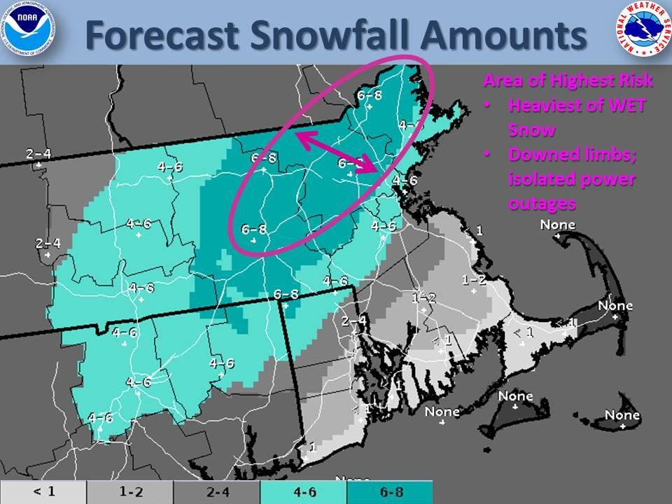
Photo credit: National Weather Service
The latest weather forecast shows Northeastern and North Central Massachusetts will likely get the highest snowfall amounts from the storm that’s expected to hit on Saturday.
The National Weather Service said the snow should begin to fall in Massachusetts at about midnight or very early Saturday morning.
Find out what's happening in Plymouthfor free with the latest updates from Patch.
The snow will change to rain/freezing rain for a time along the coast and south of the Massachusetts Turnpike on Saturday morning and early afternoon, which could make roads hazardous, before turning back to snow Saturday night.
The NWS is predicting the heaviest amounts (6 to 8 inches) will be Northeastern Massachusetts (not including the North Shore) and North Central Massachusetts. Snow may fall at a rate of an inch per hour on Saturday. The wet, heavy snow combined with wind gusts could lead to downed tree limbs and power outages.
Find out what's happening in Plymouthfor free with the latest updates from Patch.
Boston, the North Shore and southwest of Boston are expected to get 4 to 6 inches of snow.
Most of the South Shore will likely get only 1 to 2 inches with higher amounts (2 to 4 inches) in communities closer to Boston.
Cape Cod and the Islands are expected to get less than an inch, but may see wind gusts of 40 to 50 mph that could lead to power outages. Coastal flooding during the Saturday afternoon high tide is also possible.
The storm should wind down on Saturday night.
7News’ Bri Eggers said large portions of Massachusetts will see the most snowfall of the season so far from this storm.
“There is still some uncertainty with this storm. We know it’s coming. We know we’re in for it on Saturday. However, the tricky part is in the exact track of the storm, and also where the cold will be cold enough for snow to accumulate,” she said.
“All of this mess wraps up before Saturday expires, but we will still watch for the potential for minor coastal flooding during high tide around 2:30 a.m. Sunday. This will be for north-facing shorelines, mainly along the South Shore.”
Get more local news delivered straight to your inbox. Sign up for free Patch newsletters and alerts.