Weather
MN Weather: Friday Snowstorm Shifts Directions
Here are the latest updates about the snowstorm set to arrive in Minnesota Friday.


TWIN CITIES, MN — The major snowstorm set to hit Minnesota Friday has shifted directions. It will now target southwest Minnesota. However, the Twin Cities will still get hit, according to the latest forecast.
Up to 3 inches of snow could fall in the Minneapolis-St. Paul metro area.
Meanwhile, up to 6 inches of snowfall are possible in southwestern Minnesota counties, where a winter storm watch has been issued.
Find out what's happening in Across Minnesotafor free with the latest updates from Patch.
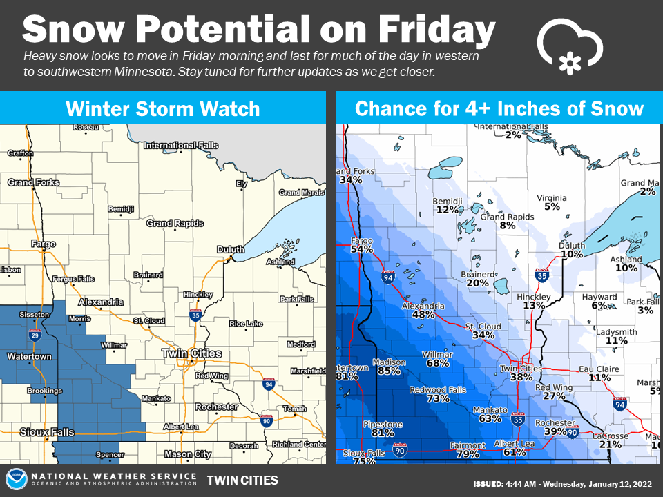
"Snowfall leading to travel impacts is expected in western to southern Minnesota on Friday, beginning during the morning and lasting through the evening," the National Weather Service said.
"Overall snow amounts will still change until we get to the event."
Find out what's happening in Across Minnesotafor free with the latest updates from Patch.
Here's the full NWS forecast for the Twin Cities metro area:
Wednesday: Partly sunny, with a high near 35. North northwest wind around 5 mph.
Wednesday Night: A slight chance of snow and freezing rain before 1am, then a chance of snow between 1am and 5am. Mostly cloudy, with a low around 22. Southwest wind 5 to 10 mph. Chance of precipitation is 30%.
Thursday: Mostly cloudy, with a high near 30. North northwest wind 5 to 10 mph.
Thursday Night: A 20 percent chance of snow after midnight. Mostly cloudy, with a low around 13. North wind 5 to 10 mph becoming east after midnight.
Friday: Snow likely. Mostly cloudy, with a high near 18. East wind around 10 mph. Chance of precipitation is 70%. New snow accumulation of 1 to 3 inches possible.
Friday Night: A 30 percent chance of snow before midnight. Cloudy, then gradually becoming partly cloudy, with a low around 1. East northeast wind 5 to 10 mph.
Saturday: Sunny, with a high near 16. North northeast wind around 5 mph becoming south in the afternoon.
Saturday Night: Mostly cloudy, with a low around 6. South wind 5 to 10 mph.
Sunday: A 20 percent chance of snow before noon. Mostly cloudy, with a high near 29. South southwest wind 5 to 10 mph becoming west in the afternoon.
Sunday Night: Mostly cloudy, with a low around 16. Northwest wind 5 to 10 mph.
M.L.King Day: Partly sunny, with a high near 25. West northwest wind 5 to 10 mph.
Monday Night: Mostly cloudy, with a low around 11. West wind around 5 mph becoming south after midnight.
Tuesday: Partly sunny, with a high near 27. South wind 5 to 10 mph becoming west northwest in the afternoon.
Get more local news delivered straight to your inbox. Sign up for free Patch newsletters and alerts.