Crime & Safety
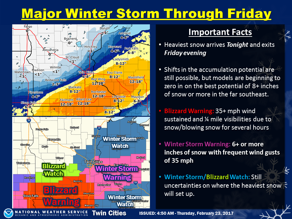
Minnesota Weather: Blizzard Watch, Warnings Issued
A foot or more of snow is expected to fall in parts of Minnesota this week.


Light snow will begin to spread across far southern Minnesota late Thursday afternoon and into the evening. Heavy snow will develop later this evening, and into Friday, with blizzard conditions developing in the far south late Thursday night.
The heaviest snowfall has shifted to the southeast part of Minnesota where a foot or more of snow is expected before it ends Friday night. Further to the northwest, very little snowfall is expected with a sharp cut off from several inches in the southern part of the Twin Cities, to only an inch in the northern suburbs.
Very difficult travel conditions are anticipated across much of the area under a blizzard and winter storm warning late tonight and into Friday.
Find out what's happening in Maple Grovefor free with the latest updates from Patch.
Central Minnesota
Several airlines, including Delta, United, American Airlines, and Sun Country Airlines have issued a travel advisory for the Midwest. The Minneapolis-Saint Paul Airport is asking travelers to heck with their airline to verify the status of your flight and to make any necessary reservation changes.
The National Weather Service in Twin Cities/Chanhassen has issued a winter storm warning for heavy snow and blowing snow, which is in effect from 6 p.m. this evening to 6 a.m. Saturday.
Find out what's happening in Maple Grovefor free with the latest updates from Patch.
- Timing: heavy snow will quickly spread in between 10 p.m. and midnight tonight.
- Snow: 8 to 12 inches are expected, with total falling off quickly north of a New Prague, to Cottage Grove, to Holcombe Wisconsin line.
- Winds: Northeast to northwest 20 to 30 mph with gusts to 40 mph resulting in considerable blowing and drifting snow.
A blizzard warning is now in effect for south central Minnesota, including the Mankato area and I-90 corridor.
A blizzard watch remains in effect from Redwood Fall over to Glencoe, with a winter storm watch still in effect for most of the Twin Cities and the US-8 corridor in northwest Wisconsin.
Snowfall totals between 12 and 15 inches are expected along and southeast of a St. James, Minnesota to Eau Claire, Wisconsin line, with a very tight gradient in snowfall totals expected northwest of this main band.
In addition, wind speeds are expected to be between 25 and 35 mph, with gusts around 40 mph in south central Minnesota. This will lead to significant blowing and drifting as well for south central Minnesota, where the blizzard warning is in effect.
The Friday morning and afternoon commutes are expected to be significantly impacted.
Snowfall rates of 1 to 2 inches per hour are likely within the intense snow band, which could persist for several hours.
Images via National Weather Service
Get more local news delivered straight to your inbox. Sign up for free Patch newsletters and alerts.