Weather
1 More Arctic Blast Before Weekend Warmup: MN Weather
Minnesotans can expect another blast of bitter arctic air before a rapid warmup this weekend.

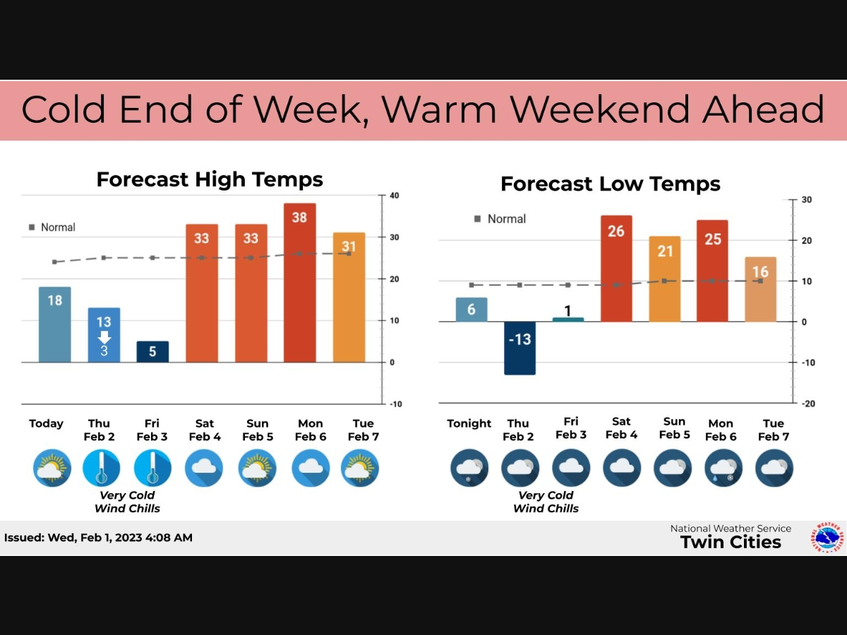
TWIN CITIES, MN — Minnesotans can expect another blast of bitter arctic air before a rapid warmup this weekend.
"Temperatures warm slightly today into Thursday morning, but then a cold front will move through and bring another round of arctic air Thursday night into Friday," the National Weather Service said.
"One more shot of very cold air is in store for the end of the week before we see a significant warm up this weekend. A few flurries are possible early tomorrow morning. Rain and snow is possible Monday night."
Find out what's happening in Minneapolisfor free with the latest updates from Patch.
Here's the full NWS forecast from the Minneapolis-St. Paul Airport:
Wednesday: Mostly sunny, with a high near 18. Wind chill values as low as -11. South southwest wind around 5 mph.
Find out what's happening in Minneapolisfor free with the latest updates from Patch.
Wednesday Night: A chance of flurries after 3am. Partly cloudy, with a low around 6. West southwest wind around 5 mph.
Thursday: A chance of flurries before 9am. Mostly sunny, with a temperature rising to near 12 by 9am, then falling to around 4 during the remainder of the day. Wind chill values as low as -14. North northwest wind 5 to 15 mph.
Thursday Night: Mostly clear, with a low around -13. Wind chill values as low as -25. Northwest wind 5 to 15 mph.
Friday: Partly sunny and cold, with a high near 5. North northwest wind 5 to 10 mph becoming south southeast in the afternoon.
Friday Night: Mostly cloudy, with a temperature rising to around 10 by 5am. South southeast wind 10 to 15 mph.
Saturday: Mostly cloudy, with a high near 33. South southeast wind 10 to 15 mph becoming southwest in the afternoon.
Saturday Night: Mostly cloudy, with a steady temperature around 31. West wind 10 to 15 mph.
Sunday: Partly sunny, with a steady temperature around 29. West northwest wind 10 to 15 mph.
Sunday Night: Mostly cloudy, with a low around 21. West southwest wind 5 to 10 mph becoming south southeast after midnight.
Monday: Cloudy, with a high near 38. South southeast wind 10 to 15 mph.
Monday Night: A slight chance of rain and snow. Mostly cloudy, with a low around 25. South wind 10 to 15 mph becoming west northwest after midnight. Chance of precipitation is 20%.
Tuesday: Partly sunny, with a high near 31. West northwest wind around 15 mph.
Get more local news delivered straight to your inbox. Sign up for free Patch newsletters and alerts.


