Weather
2-7 Inches Of Snow Possible For Twin Cities Metro: MN Weather
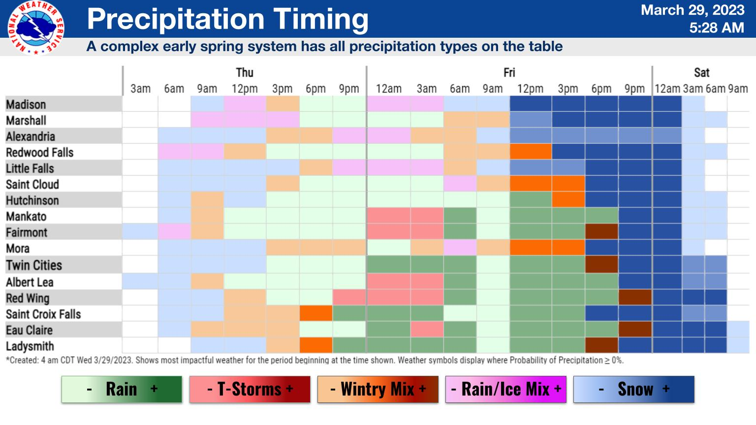
An incoming messy system will bring snow, rain, freezing rain, and gusty winds, according to the National Weather Service.


MINNEAPOLIS — A "multi-faceted" late winter storm is still on track to hit the Twin Cities metro area Thursday and Friday. In addition to several inches of snow, the messy system will bring rain, freezing rain, and gusty winds.
THURSDAY STORM UPDATE: 4-11 Inches Of Snowfall Now Possible, NWS Says: MN Weather
"Most areas will start as snow Thursday morning and transition to rain from south to north through the duration of Thursday through the night," the NWS states.
Find out what's happening in Minneapolisfor free with the latest updates from Patch.
Most areas will see the rain transition completely back to snow by 9 p.m.

Here's the specific NWS forecast from the Minneapolis-St. Paul Airport:
Find out what's happening in Minneapolisfor free with the latest updates from Patch.
Wednesday: Sunny, with a high near 29. West northwest wind 5 to 10 mph.
Wednesday Night: Mostly clear, with a low around 15. West northwest wind around 5 mph becoming calm in the evening.
Thursday: Snow likely before 3pm, then rain likely. Increasing clouds, with a high near 41. Southeast wind 5 to 15 mph, with gusts as high as 30 mph. Chance of precipitation is 70%. New snow accumulation of less than a half inch possible.
Thursday Night: Rain and possibly a thunderstorm before 4am, then rain likely. Steady temperature around 38. East southeast wind 10 to 15 mph becoming north northeast after midnight. Chance of precipitation is 90%. New rainfall amounts between a quarter and half of an inch possible.
Friday: Rain. High near 41. Breezy, with a north northeast wind 10 to 15 mph increasing to 20 to 25 mph in the afternoon. Winds could gust as high as 40 mph. Chance of precipitation is 80%. New precipitation amounts between a quarter and half of an inch possible.
Friday Night: Snow likely, possibly mixed with rain, becoming all snow after 9pm. The snow could be heavy at times. Some thunder is also possible. Widespread blowing snow, mainly between 11pm and 1am. Mostly cloudy, with a low around 22. Windy, with a north wind 25 to 30 mph, with gusts as high as 50 mph. Chance of precipitation is 60%. New snow accumulation of 4 to 8 inches possible.
Saturday: Patchy blowing snow before 7am. Sunny, with a high near 37. Breezy, with a north northwest wind 10 to 20 mph, with gusts as high as 30 mph.
Saturday Night: Partly cloudy, with a low around 27. South southeast wind 10 to 15 mph.
Sunday: Partly sunny, with a high near 52. South southeast wind around 15 mph becoming southwest in the afternoon.
Sunday Night: Partly cloudy, with a low around 33. West southwest wind 10 to 15 mph.
Monday: Mostly sunny, with a high near 50. West northwest wind around 10 mph.
Monday Night: A 40 percent chance of rain. Mostly cloudy, with a low around 34. North northwest wind 10 to 15 mph becoming east northeast after midnight.
Tuesday: Rain likely. Mostly cloudy, with a high near 46. Breezy, with an east northeast wind 15 to 20 mph, with gusts as high as 30 mph. Chance of precipitation is 60%.
Get more local news delivered straight to your inbox. Sign up for free Patch newsletters and alerts.


