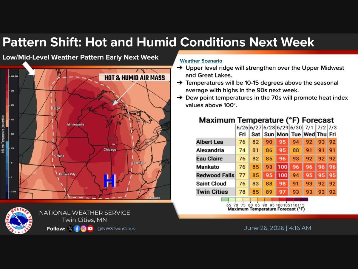
Weather
-50 Wind Chills This Week, Snowstorm Wednesday: MN Weather
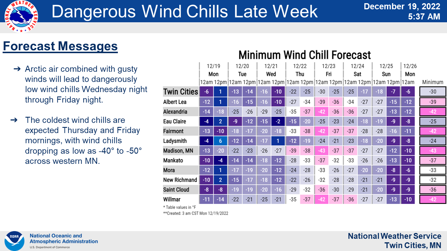
Wind chills could reach "as low as 40-50 degrees below zero Thursday and Friday morning," the National Weather Service said.


TWIN CITIES, MN — The final days before Christmas in Minnesota will feature a deep arctic blast of cold air, along with a couple of inches of snow, according to the latest forecast.
Wind chills could reach "as low as 40-50 degrees below zero Thursday and Friday morning," the National Weather Service said.
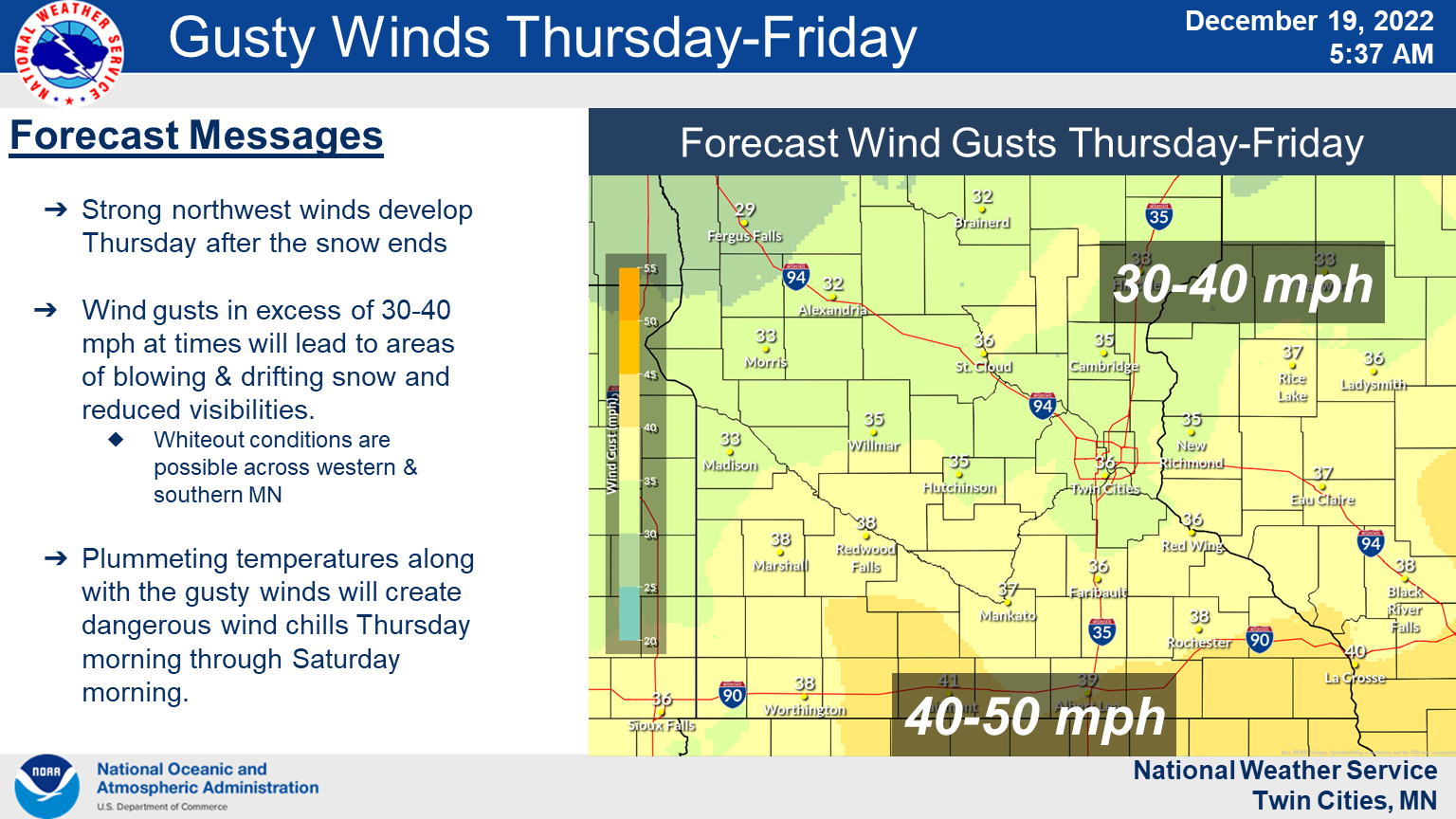
"Plowable snow (2 plus inches) is likely for much of the area Wednesday into Thursday, but there remains a good deal of uncertainty in amounts. Winds will become gusty on Thursday and remain gusty into the weekend."
Find out what's happening in Minneapolisfor free with the latest updates from Patch.
Here's the full NWS forecast from the Minneapolis-St. Paul Airport:
Find out what's happening in Minneapolisfor free with the latest updates from Patch.
Monday: A slight chance of flurries before 1pm, then snow, mainly after 1pm. High near 14. Calm wind becoming east southeast around 5 mph. Chance of precipitation is 80%. Total daytime snow accumulation of less than a half inch possible.
Monday Night: Snow likely, mainly before 11pm. Cloudy, then gradually becoming partly cloudy, with a low around 3. Wind chill values as low as -10. East wind 5 to 10 mph becoming west in the evening. Chance of precipitation is 70%. New snow accumulation of less than a half inch possible.
Tuesday: Mostly sunny, with a high near 8. Wind chill values as low as -12. West northwest wind around 10 mph.
Tuesday Night: Mostly cloudy, with a low around -6. Wind chill values as low as -16. West northwest wind 5 to 10 mph.
Wednesday: Snow likely, mainly after noon. Mostly cloudy and cold, with a high near 4. Northwest wind 5 to 10 mph. Chance of precipitation is 60%. New snow accumulation of less than one inch possible.
Wednesday Night: Snow likely, mainly before midnight. Mostly cloudy, with a low around -3. North northwest wind 5 to 15 mph. Chance of precipitation is 70%. New snow accumulation of around an inch possible.
Thursday: A 40 percent chance of snow. Mostly cloudy and cold, with a high near 0. North northwest wind around 15 mph.
Thursday Night: A 30 percent chance of snow. Mostly cloudy, with a low around -7. Blustery, with a north northwest wind 15 to 20 mph, with gusts as high as 30 mph.
Friday: A 20 percent chance of snow. Partly sunny and cold, with a high near 1. Blustery, with a northwest wind 20 to 25 mph, with gusts as high as 35 mph.
Friday Night: Partly cloudy, with a low around -6. Blustery, with a northwest wind 15 to 20 mph, with gusts as high as 35 mph.
Saturday: Mostly sunny and cold, with a high near 5. Northwest wind around 15 mph, with gusts as high as 30 mph.
Saturday Night: Partly cloudy, with a low around -5. West northwest wind around 10 mph.
Christmas Day: Partly sunny, with a high near 11. West wind around 10 mph.
Get more local news delivered straight to your inbox. Sign up for free Patch newsletters and alerts.