Weather
Up To 6 Inches Of Snow Now Possible: MN Weather
It's not a bad dream. Following the summer heat, winter weather is about to make a serious comeback in Minnesota.


MINNEAPOLIS - No, it’s not a bad dream. This is real life.
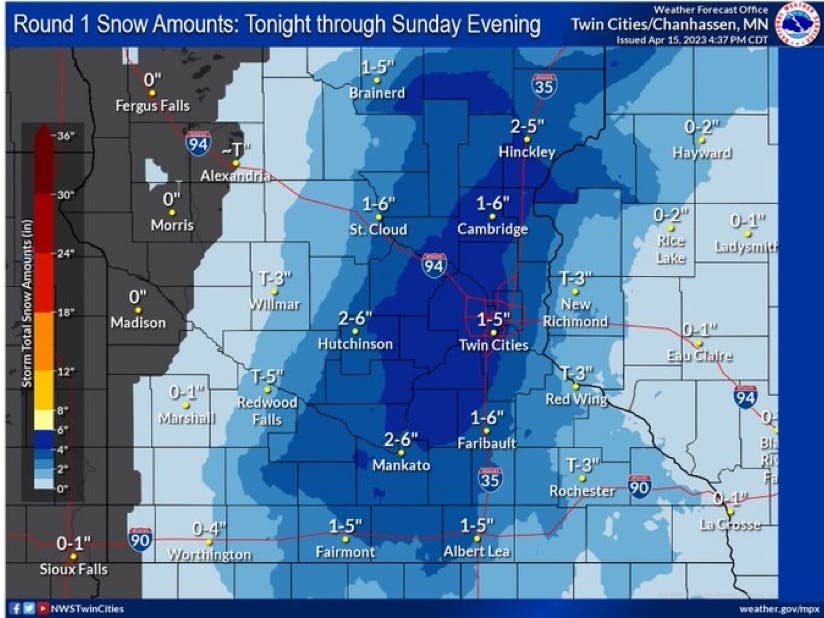
Somewhere between 1 and 5 inches of snow is expected to fall in the Twin Cities metro area Saturday night into Sunday, according to the National Weather Service.
Another inch is possible Sunday into Monday.
Find out what's happening in Minneapolisfor free with the latest updates from Patch.
“Two rounds of snow are on the way, but the big question is how much will stick,” the National Weather Service said.
“It will all depend on how fast the snow can fall to overcome the warm ground temperatures. 1" and 6" are both w/in the realm of possibilities (yup), so keep a close eye on those temperatures tomorrow.”
Find out what's happening in Minneapolisfor free with the latest updates from Patch.
Here’s the current forecast for the Minneapolis-St. Paul Airport:
This Afternoon: A 20 percent chance of rain. Cloudy, with a high near 51. North northwest wind around 15 mph.
Tonight: Rain before 4am, then snow, possibly mixed with rain. Low around 34. North northwest wind around 15 mph, with gusts as high as 25 mph. Chance of precipitation is 100%. New snow accumulation of 1 to 2 inches possible.
Sunday: Snow. Patchy blowing snow between 9am and 10am. High near 38. Breezy, with a north northwest wind 20 to 25 mph, with gusts as high as 40 mph. Chance of precipitation is 90%. New snow accumulation of 2 to 4 inches possible.
Sunday Night: Snow likely, mainly before 8pm. Cloudy, with a low around 31. Windy, with a northwest wind around 30 mph, with gusts as high as 45 mph. Chance of precipitation is 60%. New snow accumulation of less than a half inch possible.
Monday: A 30 percent chance of snow before 8am. Mostly cloudy, then gradually becoming sunny, with a high near 48. Breezy, with a northwest wind 20 to 25 mph, with gusts as high as 40 mph.
Monday Night: Mostly clear, with a low around 27. Blustery, with a north northwest wind 10 to 20 mph, with gusts as high as 30 mph.
Tuesday: Sunny, with a high near 53. North wind around 5 mph becoming east in the afternoon.
Tuesday Night: A 40 percent chance of rain after 2am. Mostly cloudy, with a low around 37. East wind 10 to 15 mph.
Wednesday: Rain likely, mainly after 8am. Mostly cloudy, with a high near 54. Breezy, with an east wind 15 to 20 mph, with gusts as high as 30 mph. Chance of precipitation is 70%.
Wednesday Night: Rain likely, mainly before 2am. Mostly cloudy, with a low around 40. East wind around 15 mph, with gusts as high as 25 mph. Chance of precipitation is 70%.
Thursday: Rain likely. Mostly cloudy, with a high near 50. Breezy, with a northeast wind 15 to 20 mph, with gusts as high as 30 mph. Chance of precipitation is 60%.
Thursday Night: Rain and snow likely. Mostly cloudy, with a low around 35. Breezy, with a northeast wind around 20 mph, with gusts as high as 30 mph. Chance of precipitation is 60%.
Friday: Rain and snow likely. Mostly cloudy, with a high near 45. Breezy, with a north wind around 20 mph, with gusts as high as 30 mph. Chance of precipitation is 60%.
Friday Night: Rain and snow likely. Mostly cloudy, with a low around 33. Breezy, with a north northwest wind 15 to 20 mph, with gusts as high as 30 mph. Chance of precipitation is 60%.
Saturday: A chance of rain and snow. Partly sunny, with a high near 46. Breezy, with a north northwest wind 15 to 20 mph, with gusts as high as 25 mph. Chance of precipitation is 40%.
Get more local news delivered straight to your inbox. Sign up for free Patch newsletters and alerts.


