Weather
Another 6 Inches Of Snow Possible In Upcoming Winter Storm: MN Weather
Yet another winter storm is headed for the Twin Cities metro area. It could drop plowable snow this week.

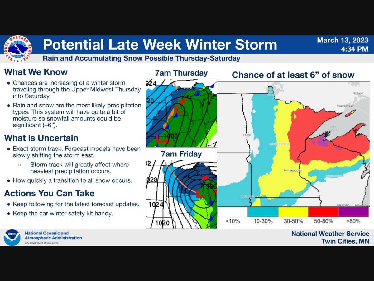
MINNEAPOLIS — Another 6 inches of snow is possible from yet another snowstorm headed our way. Residents in the Twin Cities can expect rain on Thursday before the precipitation turns to all snow later that evening.
The snow will last through Friday morning, impacting the commute to work, according to the latest forecast.
The Minneapolis-St. Paul Airport has already seen more than 80 inches of snowfall this season, making it the metro's eighth snowiest winter on record.
Find out what's happening in Minneapolisfor free with the latest updates from Patch.
Tuesday is the 105th consecutive day that the Twin Cities has had at least 1 inch of snow on the ground. Most Minnesotans haven't seen grass since Nov. 30, 2022. Don't expect to see it anytime soon.
Here's the current snowfall forecast for the region:
Find out what's happening in Minneapolisfor free with the latest updates from Patch.

Here's the specific NWS forecast from the Minneapolis-St. Paul Airport:
Tuesday: Sunny, with a high near 33. South southeast wind 5 to 15 mph.
Tuesday Night: Mostly clear, with a low around 26. South southeast wind 10 to 15 mph, with gusts as high as 25 mph.
Wednesday: Increasing clouds, with a high near 43. South southeast wind 10 to 15 mph, with gusts as high as 25 mph.
Wednesday Night: A 30 percent chance of rain, mainly after 1am. Cloudy, with a low around 34. South southeast wind 5 to 10 mph.
Thursday: Rain likely, possibly mixed with snow before 11am, then rain likely between 11am and 3pm, then snow likely, possibly mixed with rain after 3pm. Cloudy, with a temperature falling to around 32 by 5pm. Breezy, with a north wind 10 to 15 mph increasing to 15 to 20 mph in the afternoon. Winds could gust as high as 25 mph. Chance of precipitation is 70%. New snow accumulation of around an inch possible.
Thursday Night: Snow likely. Patchy blowing snow. Mostly cloudy, with a low around 21. Windy, with a north northwest wind 25 to 30 mph, with gusts as high as 40 mph. Chance of precipitation is 60%. New snow accumulation of 2 to 4 inches possible.
Friday: A 50 percent chance of snow. Areas of blowing snow. Mostly cloudy, with a high near 26. Blustery, with a north northwest wind 20 to 25 mph, with gusts as high as 35 mph.
Friday Night: A 30 percent chance of snow. Mostly cloudy, with a low around 15. Blustery, with a north northwest wind 15 to 20 mph, with gusts as high as 25 mph.
Saturday: A 20 percent chance of snow before 1pm. Mostly cloudy, with a high near 24. North northwest wind around 15 mph, with gusts as high as 25 mph.
Saturday Night: Partly cloudy, with a low around 12. West northwest wind 10 to 15 mph.
Sunday: Sunny, with a high near 31. West wind around 10 mph.
Sunday Night: Mostly clear, with a low around 14. Southwest wind around 10 mph.
Monday: Mostly sunny, with a high near 37. South southwest wind around 10 mph.
Get more local news delivered straight to your inbox. Sign up for free Patch newsletters and alerts.


