Weather
Heavy Snow, Strong Winds To Snarl Travel As Weekend Storm Targets MN
A blast of arctic air is expected to fuel a significant storm this weekend, bringing snow and strong winds to Minnesota.

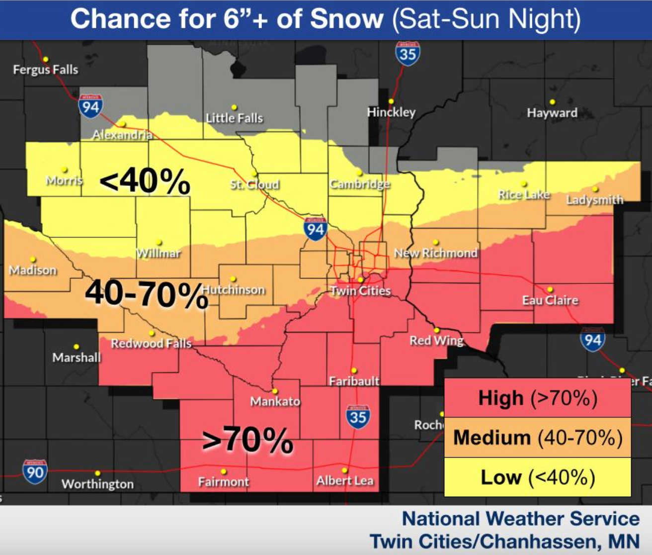
A blast of arctic air is expected to fuel what forecasters are calling the biggest snowstorm of the season for some Minnesota residents, which will likely drop more than 6 inches of snow on the Twin Cities this weekend and up to 24 inches on other parts of the state.
"After brief tastes of spring warmth across the Midwest early March, Mother Nature will send a reminder that winter is not done yet, as this powerful storm will bring the potential for some of the heaviest snow of the season across the region," AccuWeather meteorologist Brandon Buckingham said Thursday.
Before this weekend's storm, a light mix of rain and snow is expected to fall across the Twin Cities during the overnight hours Thursday into Friday. A high wind warning is in effect until 10 a.m. Friday, with northwest winds of 25 to 35 mph and gusts up to 60 mph expected.
Find out what's happening in Minneapolisfor free with the latest updates from Patch.
Later this weekend, a winter storm watch is in effect for much of central and southern Minnesota. The watch, which includes Minneapolis, St. Paul and surrounding cities and counties, starts Saturday night and continues through Monday morning.
Find out what's happening in Minneapolisfor free with the latest updates from Patch.
According to the National Weather Service, snow is expected to start falling just after midnight on Sunday and continue into the early morning hours on Monday. Heavy snow is likely during this period, forecasters said.
"The current forecast would support the heaviest snowfall falling from the Twin Cities and south/east," the National Weather Service wrote.
The Twin Cities is expected to see snow accumulations in excess of 6 inches, with localized amounts exceeding 12 inches south of the metro.
Meanwhile, portions of southeastern Minnesota into eastern Wisconsin could see total snow accumulations between 12 and 18 inches with localized amounts possibly approaching 24 inches.
In addition to snow, winds could gust as high as 45 mph.
"Travel could be very difficult to impossible. Widespread
blowing snow could significantly reduce visibility," the National Weather Service wrote. "The hazardous conditions could impact the Monday morning commute."
Here's a look at the detailed National Weather Service forecast for the Twin Cities:
Thursday Night: Rain likely before 2am, then a chance of rain and snow. Mostly cloudy, with a low around 30. Windy, with a south wind 15 to 20 mph becoming west northwest 25 to 30 mph after midnight. Winds could gust as high as 55 mph. Chance of precipitation is 70%. Little or no snow accumulation expected.
Friday: Cloudy through mid morning, then gradual clearing, with a high near 38. Breezy, with a northwest wind 15 to 25 mph, with gusts as high as 50 mph.
Friday Night: Increasing clouds, with a low around 25. Northwest wind 5 to 10 mph becoming light and variable after midnight.
Saturday: A 30 percent chance of snow, mainly after 1pm. Mostly cloudy, with a high near 40. Southeast wind 5 to 10 mph.
Saturday Night: Snow. The snow could be heavy at times. Low around 28. East northeast wind 10 to 15 mph. Chance of precipitation is 90%. New snow accumulation of 6 to 10 inches possible.
Sunday: Snow. The snow could be heavy at times. Areas of blowing snow. High near 30. Blustery, with a north wind 15 to 20 mph, with gusts as high as 35 mph. Chance of precipitation is 90%.
Sunday Night: A 30 percent chance of snow before 1am. Patchy blowing snow before 1am. Mostly cloudy, with a low around 8. Blustery, with a north northwest wind 15 to 20 mph, with gusts as high as 35 mph.
Monday: Mostly sunny, with a high near 18. Blustery, with a north northwest wind 15 to 20 mph, with gusts as high as 30 mph.
Get more local news delivered straight to your inbox. Sign up for free Patch newsletters and alerts.