Weather
'Confidence Is Increasing' For 4-6 Inches Of New Snow: MN Weather
The Twin Cities metro area is on track to get yet another snowstorm this week.


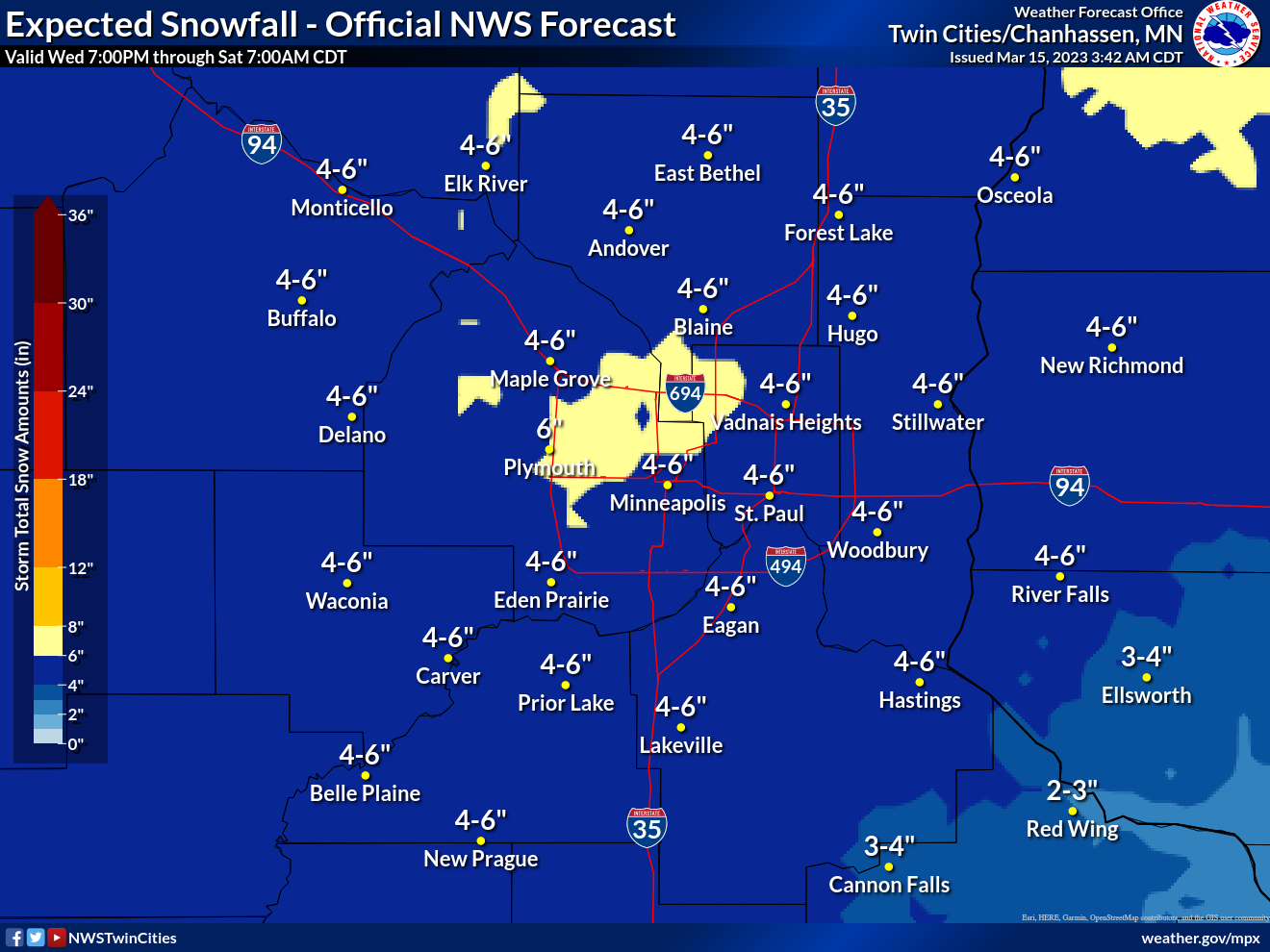
MINNEAPOLIS — Stop us if you've heard this before, but we are tracking yet another snowstorm headed for the Twin Cities metro area this week. A winter storm watch goes into effect Thursday for Isanti, Chisago, Hennepin, Anoka, Ramsey, Washington, Carver, Scott, Dakota, Rice, Polk, Barron, Rusk, and St. Croix.
"Confidence is increasing for potential accumulating snow on Thursday," the National Weather Service said.
"We’ll start out with rain, but quickly changeover to snow. Some accumulation is likely. Our temperatures will resemble mid-January rather than mid-March for the weekend."
Find out what's happening in Minneapolisfor free with the latest updates from Patch.
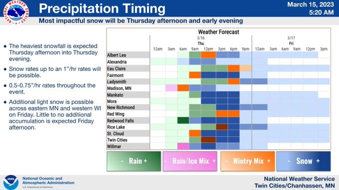
Here's when to expect precipitation and what kind:
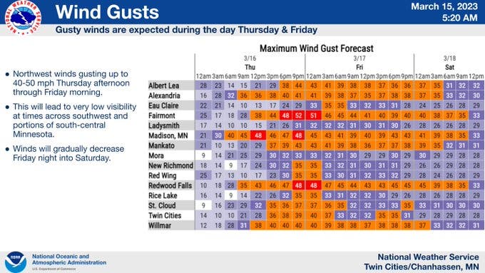
Blizzard conditions could also develop. Wind gusts are also expected to pick up in the second half of this week:
Find out what's happening in Minneapolisfor free with the latest updates from Patch.
The Minneapolis-St. Paul Airport has already seen more than 80 inches of snowfall this season, making it the metro's eighth snowiest winter on record.
Wednesday is the 106th consecutive day that the Twin Cities has had at least 1 inch of snow on the ground. Most Minnesotans haven't seen grass since Nov. 30, 2022. Don't expect to see it anytime soon.
And here's the specific NWS forecast from the Minneapolis-St. Paul Airport:
Wednesday: Partly sunny, with a high near 44. South southeast wind 10 to 15 mph.
Wednesday Night: A 20 percent chance of rain after 4am. Cloudy, with a low around 35. Southeast wind 5 to 10 mph.
Thursday: Snow, possibly mixed with rain and sleet, becoming all snow after 3pm. The snow could be heavy at times. Widespread blowing snow, mainly after 5pm. Temperature falling to around 31 by 5pm. Breezy, with a north wind 5 to 10 mph increasing to 15 to 20 mph in the afternoon. Winds could gust as high as 35 mph. Chance of precipitation is 100%. New snow and sleet accumulation of 2 to 4 inches possible.
Thursday Night: Snow, mainly before 1am. The snow could be heavy at times. Widespread blowing snow, mainly before 7pm. Low around 18. Windy, with a north northwest wind 25 to 30 mph, with gusts as high as 45 mph. Chance of precipitation is 80%. New snow accumulation of 1 to 3 inches possible.
Friday: A 40 percent chance of snow. Patchy blowing snow. Mostly cloudy, with a high near 24. Blustery, with a northwest wind around 25 mph, with gusts as high as 40 mph.
Friday Night: A 30 percent chance of snow. Patchy blowing snow before 4am. Mostly cloudy, with a low around 14. Blustery, with a northwest wind 20 to 25 mph, with gusts as high as 40 mph.
Saturday: A 20 percent chance of snow before 1pm. Mostly cloudy, with a high near 24. Blustery, with a north northwest wind 15 to 20 mph, with gusts as high as 30 mph.
Saturday Night: Partly cloudy, with a low around 8. West northwest wind 10 to 15 mph.
Sunday: Sunny, with a high near 28. West southwest wind around 10 mph.
Sunday Night: Mostly clear, with a low around 12. South southwest wind around 10 mph.
Monday: Mostly sunny, with a high near 36. South southwest wind around 10 mph.
Monday Night: A slight chance of snow and freezing rain. Mostly cloudy, with a low around 24. South wind around 10 mph. Chance of precipitation is 20%.
Tuesday: A slight chance of rain and snow. Partly sunny, with a high near 40. South southeast wind around 10 mph. Chance of precipitation is 20%.
Get more local news delivered straight to your inbox. Sign up for free Patch newsletters and alerts.