Weather
Cool Front Moves In Through The Twin Cities: MN Weather
Fall temperatures will return to Minnesota, along with chances for rain and thunderstorms Tuesday.


MINNEAPOLIS — Minnesota's stint with summer-like weather will come to a close Tuesday as a cold front moves in, bringing fall temperatures along with chances for showers and thunderstorms.
"An incoming cold front will bring the threat for strong to severe thunderstorms across western Minnesota Tuesday evening," the National Weather Service said. "Damaging winds and large hail will be the primary storm threats. Rain is forecast to continue eastward into the overnight hours."
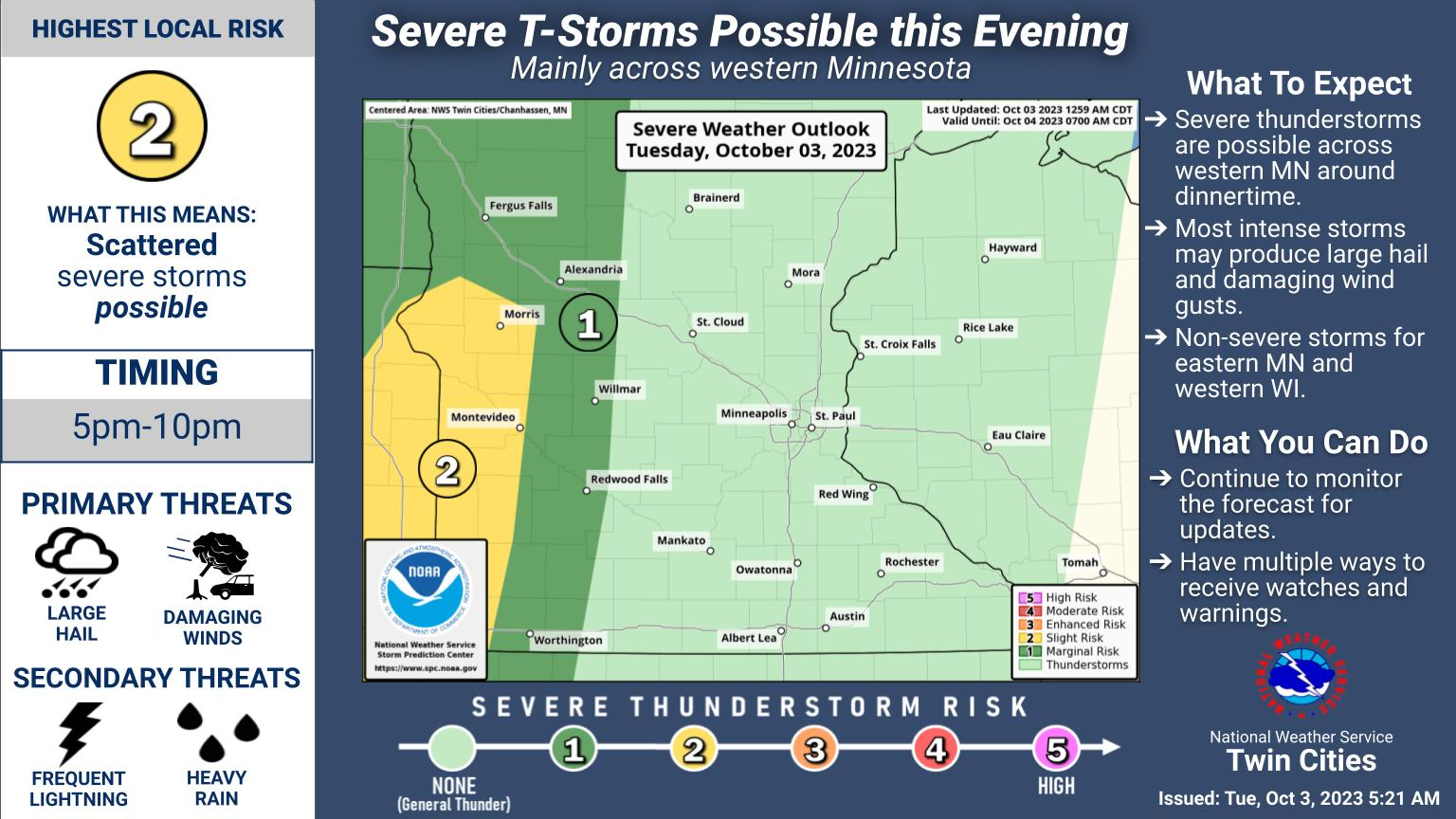
Here's the specific NWS forecast from the Minneapolis-St. Paul Airport:
Find out what's happening in Minneapolisfor free with the latest updates from Patch.
Tuesday: Increasing clouds, with a high near 84. Breezy, with a south wind 15 to 20 mph, with gusts as high as 30 mph.
Tuesday Night: Showers and thunderstorms likely before 4am, then a chance of showers. Cloudy, with a low around 63. South wind around 15 mph, with gusts as high as 30 mph. Chance of precipitation is 70%. New rainfall amounts between a tenth and quarter of an inch, except higher amounts possible in thunderstorms.
Find out what's happening in Minneapolisfor free with the latest updates from Patch.
Wednesday: A 10 percent chance of showers before 7am. Mostly cloudy, with a high near 68. West wind 10 to 15 mph.
Wednesday Night: Partly cloudy, with a low around 54. Southwest wind 5 to 10 mph.
Thursday: A 20 percent chance of showers after 1pm. Mostly sunny, with a high near 64. Breezy, with a west wind 10 to 15 mph increasing to 20 to 25 mph in the afternoon. Winds could gust as high as 35 mph.
Thursday Night: A 20 percent chance of showers after 1am. Mostly cloudy, with a low around 46. Breezy, with a west wind 20 to 25 mph, with gusts as high as 35 mph.
Friday: Showers likely, mainly after 1pm. Mostly cloudy, with a high near 54. Breezy, with a northwest wind 15 to 20 mph, with gusts as high as 30 mph. Chance of precipitation is 60%.
Friday Night: Partly cloudy, with a low around 41. Breezy, with a northwest wind 10 to 20 mph, with gusts as high as 30 mph.
Saturday: Mostly sunny, with a high near 54. Northwest wind around 10 mph.
Saturday Night: Partly cloudy, with a low around 41. West wind 5 to 10 mph.
Sunday: Mostly sunny, with a high near 61. West southwest wind 5 to 10 mph becoming northwest in the afternoon.
Sunday Night: Mostly clear, with a low around 43. North northwest wind 5 to 10 mph becoming northeast after midnight.
Monday: Sunny, with a high near 64. North northwest wind 5 to 10 mph.
Get more local news delivered straight to your inbox. Sign up for free Patch newsletters and alerts.


