Weather
'Dangerously' Cold, Arctic Air On Its Way: MN Weather
It's been an extremely mild winter so far, but temperatures are finally about to get truly cold in Minnesota.


TWIN CITIES, MN — It's been an extremely mild winter so far, but temperatures are finally about to get truly cold in Minnesota.
"A surge of arctic air will move across the region this weekend and last into next week. Temperatures will be below zero," the National Weather Service said. "The coldest stretch will be Saturday night into Monday morning."
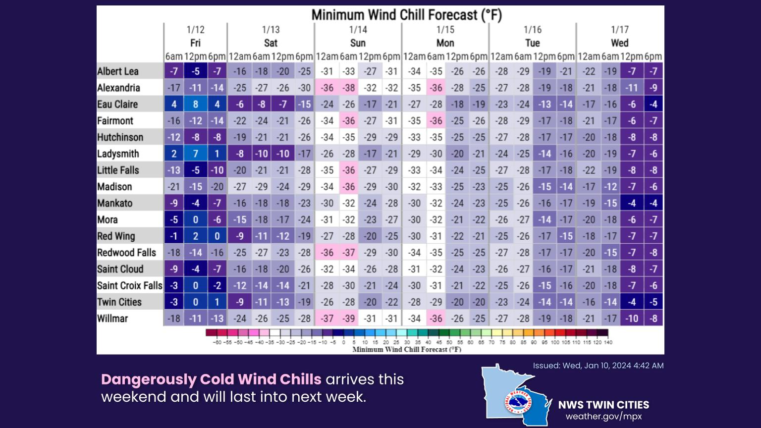
Temperatures are expected to fall to 10 degrees below zero in the Twin Cities metro area, and it'll feel even colder. Wild chills could reach more than 30 degrees below zero this weekend.:
Find out what's happening in Minneapolisfor free with the latest updates from Patch.
See the graph below for more info:
As for snow, the forecast remains modest. Wednesday will feature a chance for light snow.
Find out what's happening in Minneapolisfor free with the latest updates from Patch.
Here's the specific NWS forecast from the Minneapolis-St. Paul Airport:
Wednesday: Snow likely, mainly after 3pm. Cloudy, with a high near 27. West southwest wind around 5 mph becoming east in the afternoon. Chance of precipitation is 70%. Total daytime snow accumulation of less than a half inch possible.
Wednesday Night: Snow, mainly before 10pm. Patchy fog between 9pm and 4am. Low around 14. Calm wind becoming west northwest around 5 mph after midnight. Chance of precipitation is 80%. New snow accumulation of less than a half inch possible.
Thursday: Partly sunny, with a temperature falling to around 12 by 5pm. West wind 5 to 10 mph.
Thursday Night: Mostly cloudy, with a low around 8. West northwest wind 5 to 10 mph.
Friday: A 30 percent chance of snow, mainly after noon. Cloudy, with a high near 19. Blustery, with a north wind 10 to 15 mph increasing to 15 to 20 mph in the afternoon. Winds could gust as high as 30 mph.
Friday Night: A 40 percent chance of snow. Mostly cloudy, with a low around 5. Blustery, with a north wind around 20 mph, with gusts as high as 30 mph.
Saturday: A 30 percent chance of snow, mainly before noon. Cloudy, with a high near 9. Blustery, with a northwest wind 15 to 20 mph, with gusts as high as 30 mph.
Saturday Night: Mostly cloudy, with a low around -9. Northwest wind around 15 mph, with gusts as high as 25 mph.
Sunday: Partly sunny and cold, with a high near 0. West northwest wind around 15 mph.
Sunday Night: Mostly cloudy, with a low around -10. West northwest wind around 15 mph.
M.L.King Day: Mostly cloudy and cold, with a high near 1. West wind around 15 mph.
Monday Night: Mostly cloudy, with a low around -6. West wind around 15 mph.
Tuesday: Mostly sunny, with a high near 6. West wind around 15 mph.
Get more local news delivered straight to your inbox. Sign up for free Patch newsletters and alerts.


