Weather
Dusting Of Snow On Deck For Twin Cities: MN Weather
The big storm is over, but there are still several chances for snow ahead for the Twin Cities metro area, including Friday.

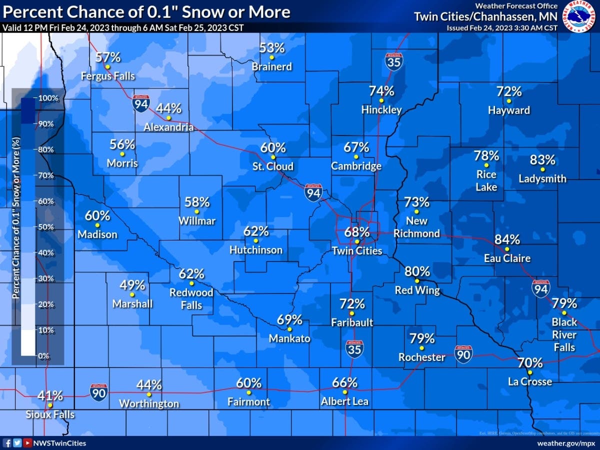
TWIN CITIES, MN — The big storm is over, but there are still several chances for snow ahead for the Twin Cities metro area, including Friday.
"A few hours of light snow will develop this evening across eastern MN & western WI," the National Weather Service said.
"Looking ahead, another strong system is forecast to impact portions of the area late Sunday night into Monday. A wintry mix is likely."
Find out what's happening in Minneapolisfor free with the latest updates from Patch.
Also read: These 10 Cities Saw The Highest Snowfall This Week: MN Weather
Here's the specific NWS forecast from the Minneapolis-St. Paul Airport:
Find out what's happening in Minneapolisfor free with the latest updates from Patch.
Friday: A 20 percent chance of snow after 4pm. Partly sunny, with a high near 12. Wind chill values as low as -14. Calm wind becoming south southeast around 5 mph in the afternoon.
Friday Night: Snow likely, mainly before 9pm. Mostly cloudy, with a low around 3. South southwest wind around 5 mph. Chance of precipitation is 70%. New snow accumulation of less than one inch possible.
Saturday: Mostly sunny, with a high near 26. South southwest wind 5 to 15 mph.
Saturday Night: Mostly clear, with a low around 9. West wind 5 to 10 mph.
Sunday: Sunny, with a high near 35. Southeast wind 5 to 15 mph.
Sunday Night: Rain before 2am, then rain, possibly mixed with snow. Low around 30. Breezy, with an east southeast wind 15 to 20 mph, with gusts as high as 30 mph. Chance of precipitation is 80%. New snow accumulation of less than a half inch possible.
Monday: Rain and snow, becoming all snow after 3pm. High near 35. East wind around 15 mph becoming northwest in the afternoon. Chance of precipitation is 90%. New precipitation amounts between a quarter and half of an inch possible.
Monday Night: A 20 percent chance of snow before midnight. Mostly cloudy, then gradually becoming mostly clear, with a low around 21. West northwest wind around 15 mph, with gusts as high as 25 mph.
Tuesday: Mostly sunny, with a high near 34. West northwest wind 10 to 15 mph becoming south southwest in the afternoon.
Tuesday Night: A 20 percent chance of snow after midnight. Mostly cloudy, with a low around 24. South wind 5 to 10 mph becoming east after midnight.
Wednesday: A 40 percent chance of snow. Mostly cloudy, with a high near 36. East wind 10 to 15 mph becoming north northeast in the afternoon.
Wednesday Night: A 30 percent chance of snow. Mostly cloudy, with a low around 17. Northwest wind 10 to 15 mph.
Thursday: A 20 percent chance of snow. Partly sunny, with a high near 29. North northwest wind 10 to 15 mph.
Get more local news delivered straight to your inbox. Sign up for free Patch newsletters and alerts.


