Weather
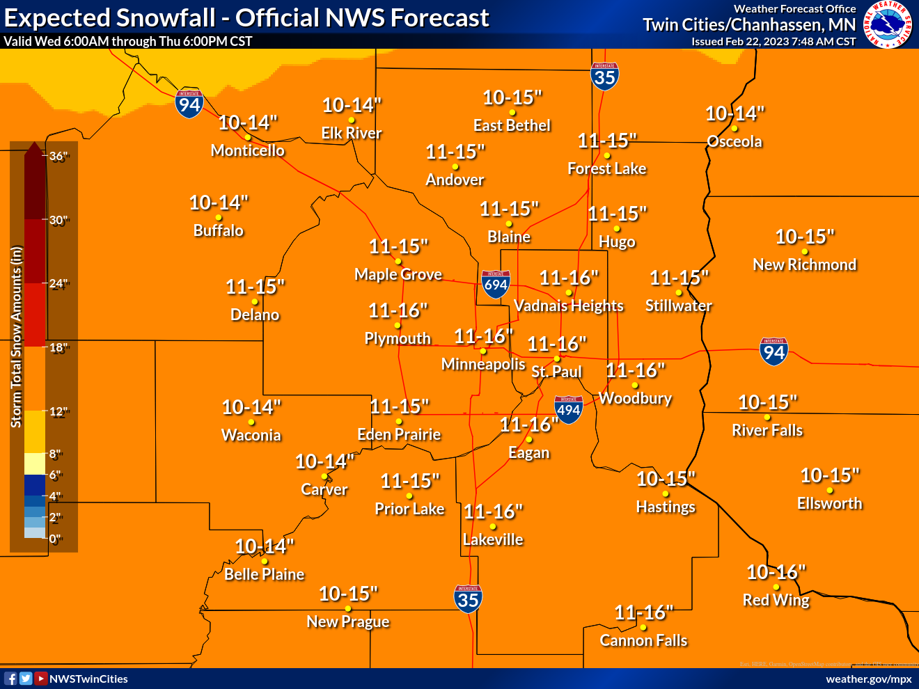
Expect 11-16 Inches Of Snow Wednesday-Thursday: MN Weather
Forecasted snowfall totals for this storm have decreased by one or two inches, but round two of the storm is still expected to pack a punch.


MINNEAPOLIS — Minnesotans woke up to between 3 to 5 inches of snowfall from round one of this week's much-anticipated storm. But that was just the warmup act.
Things will remain calm before a more intense round two of the winter storm arrives Wednesday afternoon.
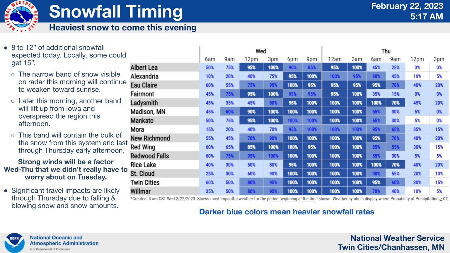
"Later this morning, another band will lift up from Iowa and overspread the region this afternoon," the National Weather Service said.
Find out what's happening in Minneapolisfor free with the latest updates from Patch.
"This band will contain the bulk of the snow from this system and last through Thursday early afternoon. Strong winds will be a factor Wed-Thu that we didn’t really have to worry about on Tuesday."
Forecasted snowfall totals have decreased by one or two inches, but round two of the storm is still expected to pack a punch.
Find out what's happening in Minneapolisfor free with the latest updates from Patch.
Here's the specific NWS forecast from the Minneapolis-St. Paul Airport:
Wednesday: Snow. Patchy blowing snow. High near 23. Blustery, with a northeast wind 20 to 25 mph, with gusts as high as 45 mph. Chance of precipitation is 100%. Total daytime snow accumulation of 2 to 4 inches possible.
Wednesday Night: Snow. The snow could be heavy at times. Widespread blowing snow. Low around 16. Windy, with a northeast wind 20 to 30 mph, with gusts as high as 45 mph. Chance of precipitation is 100%. New snow accumulation of 7 to 11 inches possible.
Thursday: Snow, mainly before noon. The snow could be heavy at times. Areas of blowing snow before 10am. Temperature falling to around 13 by 5pm. Blustery, with a northeast wind 15 to 20 mph becoming north northwest in the afternoon. Winds could gust as high as 35 mph. Chance of precipitation is 90%. New snow accumulation of 2 to 4 inches possible.
Thursday Night: Mostly cloudy, with a low around -7. Wind chill values as low as -15. Northwest wind 5 to 15 mph.
Friday: Partly sunny, with a high near 10. West northwest wind around 5 mph becoming south in the afternoon.
Friday Night: A 20 percent chance of snow before midnight. Mostly cloudy, with a low around 3. South wind 5 to 10 mph.
Saturday: Mostly sunny, with a high near 26. South southwest wind 10 to 15 mph.
Saturday Night: Mostly clear, with a low around 5. West wind 5 to 10 mph.
Sunday: Sunny, with a high near 36. South southeast wind 5 to 10 mph.
Sunday Night: A slight chance of rain before 9pm, then a chance of freezing rain. Mostly cloudy, with a low around 29. South southeast wind 10 to 15 mph. Chance of precipitation is 40%.
Monday: A chance of rain, snow, and freezing rain. Mostly cloudy, with a high near 39. East wind 10 to 15 mph becoming northwest in the afternoon. Winds could gust as high as 25 mph. Chance of precipitation is 40%.
Monday Night: Partly cloudy, with a low around 19. Blustery, with a northwest wind 15 to 20 mph, with gusts as high as 30 mph.
Tuesday: Mostly sunny, with a high near 31. West wind 10 to 15 mph.
Get more local news delivered straight to your inbox. Sign up for free Patch newsletters and alerts.


