Weather
Fire Risk Rises Saturday As Warmup Follows Rain, Cold Snap: MN Weather
The National Weather Service warns dry, windy conditions could bring near-critical fire danger across parts of Minnesota.

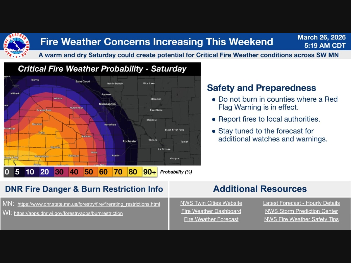
MINNEAPOLIS, MN — Dry and windy conditions expected Saturday could bring an increased risk of fire weather across parts of Minnesota, according to the National Weather Service.
Forecasters say warmer temperatures moving in this weekend will combine with low humidity and gusty winds, creating conditions that could approach critical fire danger, especially in southwestern Minnesota.
Officials are urging residents to avoid outdoor burning and use caution with anything that could spark a fire.
Find out what's happening in Minneapolisfor free with the latest updates from Patch.
The fire risk comes after a stretch of unsettled weather. Rain moving across central Minnesota and western Wisconsin is expected to end Thursday morning, followed by falling temperatures and cloudy, breezy conditions through the day.
Friday will be sunnier but colder, with highs in the 30s and gusty winds. A slight chance of snow is possible in eastern Minnesota and western Wisconsin.
Find out what's happening in Minneapolisfor free with the latest updates from Patch.
Temperatures rebound into the 50s Saturday and climb into the upper 60s by Sunday, with mostly sunny skies expected.
Warmer conditions are expected to continue into early next week, with chances for rain returning by Tuesday.
Here's the full NWS forecast from the Minneapolis-St. Paul Airport:
Today: A chance of showers before 11am, then a chance of sprinkles with a slight chance of rain between 11am and noon. Cloudy, with a temperature falling to around 47 by 5pm. North wind around 15 mph, with gusts as high as 25 mph. Chance of precipitation is 40%.
Tonight: Cloudy during the early evening, then gradual clearing, with a low around 27. North northeast wind 5 to 15 mph.
Friday: Mostly sunny, with a high near 38. Breezy, with a northwest wind 10 to 20 mph, with gusts as high as 30 mph.
Friday Night: Mostly clear, with a low around 25. Northwest wind 5 to 15 mph becoming south southwest after midnight.
Saturday: Partly sunny, with a high near 53. South wind 10 to 15 mph.
Saturday Night: Partly cloudy, with a low around 38. South wind around 10 mph.
Sunday: Mostly sunny, with a high near 68. South wind around 10 mph.
Sunday Night: Mostly clear, with a low around 42. South wind around 5 mph becoming north after midnight.
Monday: Partly sunny, with a high near 62. Northeast wind 5 to 10 mph.
Monday Night: A 20 percent chance of showers after 1am. Mostly cloudy, with a low around 42. East northeast wind around 10 mph.
Tuesday: A 40 percent chance of showers. Mostly cloudy, with a high near 60. East southeast wind 10 to 15 mph.
Tuesday Night: A 40 percent chance of showers and thunderstorms. Mostly cloudy, with a low around 41. East wind around 10 mph becoming north after midnight.
Wednesday: A 40 percent chance of showers. Mostly cloudy, with a high near 54. North wind around 10 mph.
Get more local news delivered straight to your inbox. Sign up for free Patch newsletters and alerts.


