Weather
Freezing Rain Arrives, Snow On Track For Friday Night: MN Weather
Friday will feature a messy mix of precipitation, but you will likely have to shovel several inches of snow when all is said and done.


MINNEAPOLIS — Freezing rain arrived overnight in the Twin Cities metro area. Commuters heading to work Friday morning should be cautious for slippery roads.
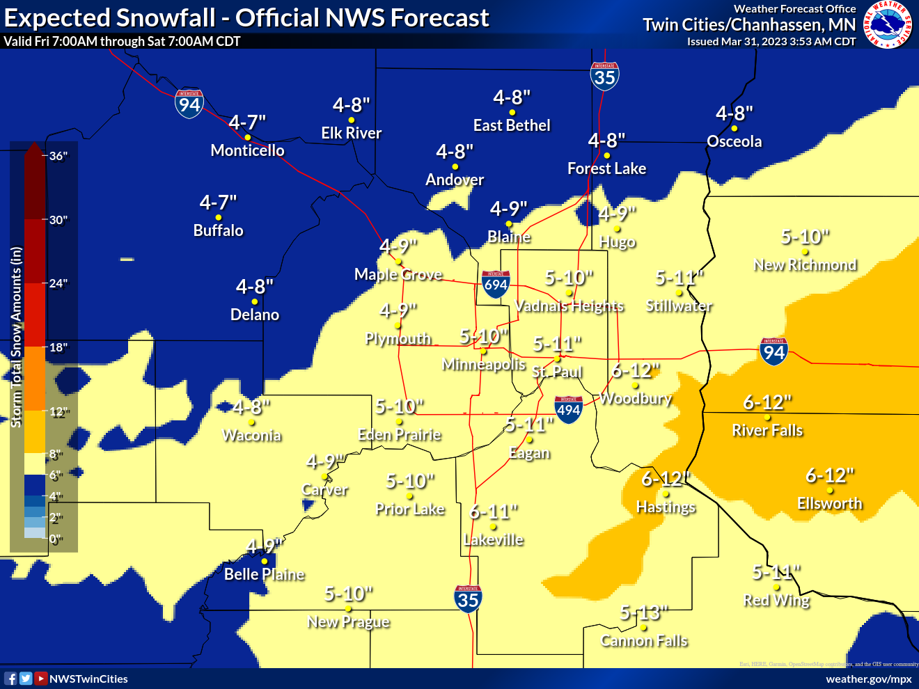
The metro is still on track to get several inches of snow Friday night, once the temperature drops below freezing.
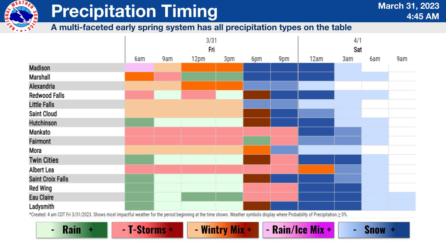
"Icing overnight has led to slick roads in western MN," the National Weather Service said. "Rain elsewhere will transition to heavy snow later tonight. Prior to this, a few hours of showers and thunderstorms are likely."
Find out what's happening in Minneapolisfor free with the latest updates from Patch.
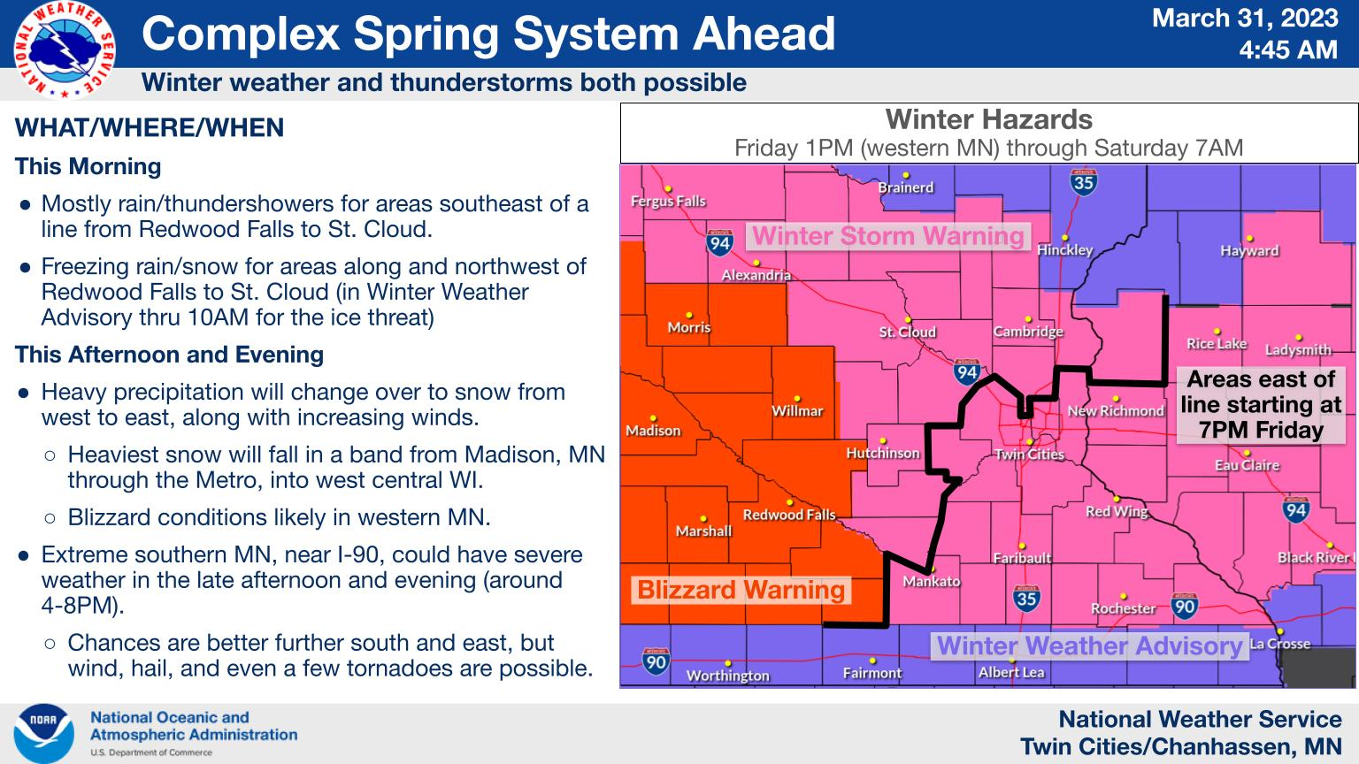
When the storm is over, the Twin Cities will end up with somewhere between 4 and 11 inches of snow Saturday morning
Find out what's happening in Minneapolisfor free with the latest updates from Patch.
Here's the specific NWS forecast from the Minneapolis-St. Paul Airport:
Friday: Rain and possibly a thunderstorm before 3pm, then rain between 3pm and 4pm, then rain and possibly a thunderstorm after 4pm. High near 40. Breezy, with a northeast wind 15 to 25 mph, with gusts as high as 35 mph. Chance of precipitation is 90%. New rainfall amounts between a quarter and half of an inch possible.
Friday Night: Rain, snow, and freezing rain, becoming all snow after 11pm. The snow could be heavy at times. Some thunder is also possible. Widespread blowing snow, mainly between 10pm and 4am. Low around 23. Windy, with a north wind 25 to 30 mph, with gusts as high as 45 mph. Chance of precipitation is 100%. New ice accumulation of less than a 0.1 of an inch possible. New snow accumulation of 4 to 8 inches possible.
Saturday: A 30 percent chance of snow before 7am. Patchy blowing snow before 9am. Sunny, with a high near 37. Breezy, with a north wind 15 to 20 mph decreasing to 5 to 10 mph in the afternoon. Winds could gust as high as 30 mph.
Saturday Night: Increasing clouds, with a low around 24. South southeast wind 5 to 15 mph.
Sunday: Partly sunny, with a high near 49. Breezy, with a south southeast wind around 20 mph becoming west southwest in the afternoon. Winds could gust as high as 35 mph.
Sunday Night: Partly cloudy, with a low around 32. Breezy, with a west southwest wind 15 to 20 mph, with gusts as high as 35 mph.
Monday: Partly sunny, with a high near 45. West wind 10 to 15 mph becoming north northwest in the afternoon.
Monday Night: A chance of rain before 2am, then a chance of rain and snow. Mostly cloudy, with a low around 32. Northeast wind 10 to 15 mph. Chance of precipitation is 40%.
Tuesday: Rain and snow, becoming all rain after 4pm. High near 40. Breezy, with an east northeast wind 15 to 20 mph, with gusts as high as 35 mph. Chance of precipitation is 90%.
Tuesday Night: Rain before 9pm, then rain and snow. Some thunder is also possible. Low around 29. Blustery, with an east northeast wind 20 to 25 mph, with gusts as high as 35 mph. Chance of precipitation is 90%.
Wednesday: Rain and snow likely. Partly sunny, with a high near 40. Breezy, with a west wind 20 to 25 mph, with gusts as high as 35 mph. Chance of precipitation is 60%.
Wednesday Night: A 20 percent chance of snow. Mostly cloudy, with a low around 21. Breezy, with a west wind 15 to 20 mph, with gusts as high as 30 mph.
Thursday: Mostly sunny, with a high near 41. West wind 10 to 15 mph.
Get more local news delivered straight to your inbox. Sign up for free Patch newsletters and alerts.


