Weather
How Much Snow To Expect In The Twin Cities: MN Weather
A winter storm warning is in effect for the Twin Cities metro area. Extremely cold air and blowing snow will make travel dangerous.

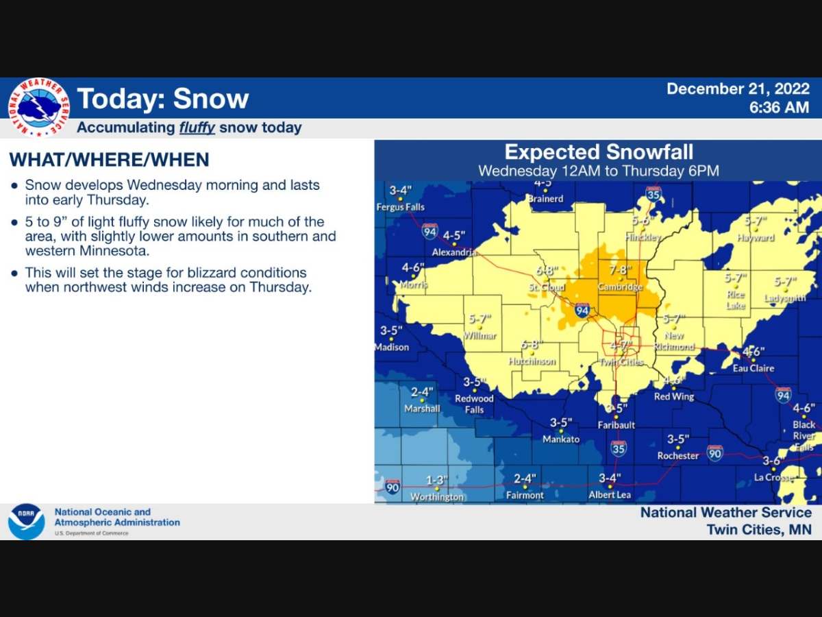
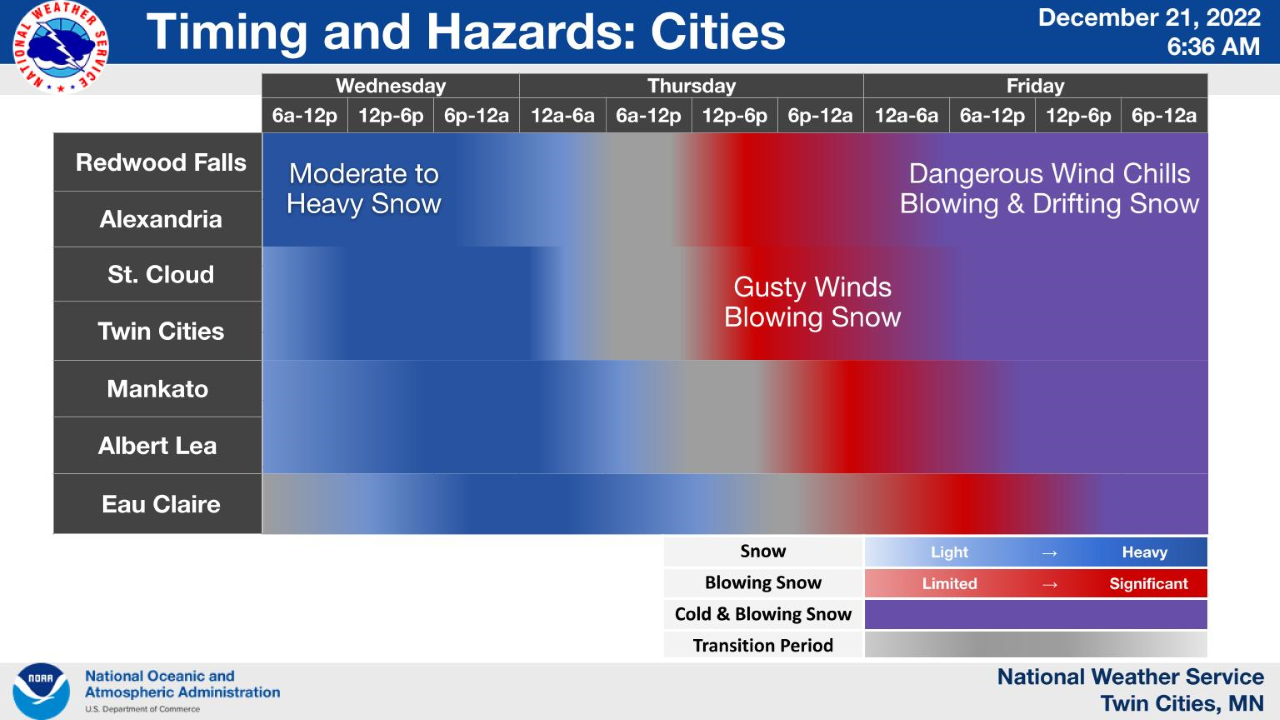
TWIN CITIES, MN — This week's potentially life-threatening winter storm is still on track to arrive Wednesday, bringing extreme cold and blizzard conditions through Friday.
The National Weather Service has issued a winter storm warning for Chisago, Hennepin, Anoka, Ramsey, Washington, and Dakota County.
Up to 7 inches of snow could fall in the metro area on Wednesday before the dangerous winds pick up on Thursday and Friday.
Find out what's happening in Minneapolisfor free with the latest updates from Patch.
Snow totals could be higher in some parts, according to AccuWeather.
"The dangerously cold wind chills as low as 35 below zero could cause frostbite on exposed skin in as little as 10 minutes," the NWS warns.
Find out what's happening in Minneapolisfor free with the latest updates from Patch.
Below are the most likely snowfall amounts for the Minneapolis-St. Paul metro area:
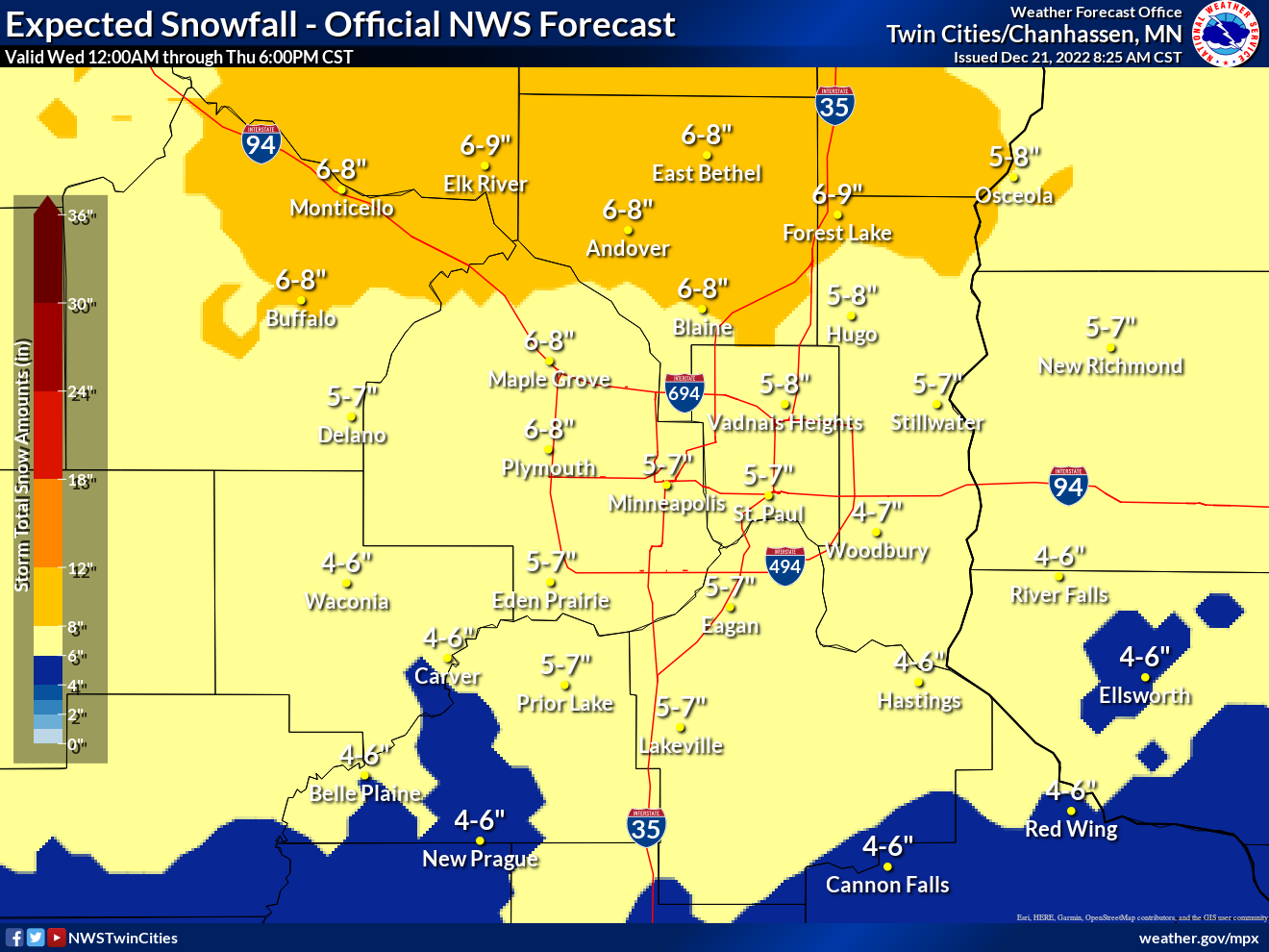
There is a small chance — 10 percent — that the metro could see up to 8 inches of snow:

But weather forecasters are confident that strong northwest winds gusting as high as 50 mph will create greatly reduce visibility. Power line and tree damage is likely to occur across the region.
Travel will be impossible at times.
The Minnesota Department of Public Safety recommends that drivers store safety items in the passenger compartment because the trunk can become jammed or frozen shut after a crash.
These five items are a must:
- Booster cables
- Sand or cat litter, to create wheel traction
- Shovel
- Tow cables or chain
- Sleeping bag and/or blankets
If you can, fit these items in your vehicle as well:
- Candles and matches
- Flashlight, extra batteries
- Snowmobile suit, snow boots
- Road flares or reflectors
- Non-perishable food
Check out winter driving tips here.
Here's the full NWS forecast from the Minneapolis-St. Paul Airport:
Wednesday: Snow, mainly after 8am. The snow could be heavy at times. High near 4. Wind chill values as low as -17. East wind 5 to 10 mph. Chance of precipitation is 100%. Total daytime snow accumulation of 3 to 5 inches possible.
Wednesday Night: Snow, mainly before 4am. Low around -6. Wind chill values as low as -21. East northeast wind 5 to 15 mph becoming northwest after midnight. Chance of precipitation is 100%. New snow accumulation of 2 to 4 inches possible.
Thursday: Patchy blowing snow after 2pm. Partly sunny and cold, with a high near -2. Wind chill values as low as -28. Blustery, with a northwest wind 15 to 20 mph, with gusts as high as 30 mph.
Thursday Night: Widespread blowing snow, mainly after 3am. Mostly cloudy, with a low around -9. Wind chill values as low as -34. Blustery, with a northwest wind 20 to 25 mph, with gusts as high as 30 mph.
Friday: Widespread blowing snow. Partly sunny and cold, with a high near -1. Blustery, with a northwest wind around 25 mph, with gusts as high as 40 mph.
Friday Night: Widespread blowing snow, mainly before 11pm. Partly cloudy, with a low around -7. Blustery, with a west northwest wind 20 to 25 mph, with gusts as high as 40 mph.
Saturday: Areas of blowing snow before 4pm. Sunny and cold, with a high near 4. Blustery, with a west northwest wind 15 to 20 mph, with gusts as high as 30 mph.
Saturday Night: Mostly clear, with a low around -11. West northwest wind 5 to 10 mph.
Christmas Day: A 20 percent chance of snow after noon. Increasing clouds, with a high near 10. West wind 5 to 10 mph becoming south southeast in the afternoon.
Sunday Night: A 20 percent chance of snow before midnight. Mostly cloudy, with a low around 0. South southeast wind 5 to 10 mph becoming north northwest in the evening.
Monday: Mostly sunny, with a high near 12. West northwest wind around 10 mph.
Monday Night: Mostly cloudy, with a low around 0. West wind around 5 mph becoming south southwest after midnight.
Tuesday: Partly sunny, with a high near 19. South wind 5 to 10 mph.
Get more local news delivered straight to your inbox. Sign up for free Patch newsletters and alerts.


