Weather
At Long Last, Warm Temperatures Are On Their Way: MN Weather
The National Oceanic and Atmospheric Administration's mid-range forecast shows heat finally making its way to Minnesota.

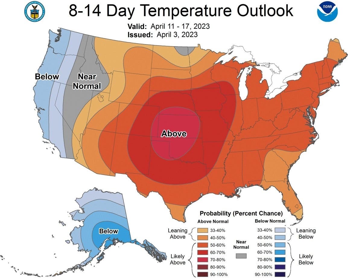
MINNEAPOLIS — Warm, above-average temperatures are finally on their way to the Twin Cities metro area later this month. The National Oceanic and Atmospheric Administration released its mid-range forecast, and it shows warmer weather for Minnesota starting in about eight days.
Temperatures will remain seasonable until then, with highs reaching 60 degrees this weekend.
Here's the specific NWS forecast from the Minneapolis-St. Paul Airport for the next seven days:
Find out what's happening in Minneapolisfor free with the latest updates from Patch.
Tuesday: A chance of rain and snow before 11am, then rain. Some thunder is also possible. High near 39. Breezy, with an east northeast wind 15 to 25 mph, with gusts as high as 40 mph. Chance of precipitation is 80%. Little or no snow accumulation expected.
Tuesday Night: Rain and possibly a thunderstorm, mainly before 2am, then a chance of rain and thunderstorms after 2am. Steady temperature around 38. Breezy, with an east wind 20 to 25 mph decreasing to 10 to 15 mph after midnight. Winds could gust as high as 40 mph. Chance of precipitation is 80%. New rainfall amounts between a quarter and half of an inch possible.
Find out what's happening in Minneapolisfor free with the latest updates from Patch.
Wednesday: A chance of rain before 10am, then a chance of rain and snow between 10am and 11am, then a chance of snow after 11am. Mostly cloudy, with a temperature falling to around 32 by 4pm. Windy, with a west southwest wind 15 to 20 mph increasing to 25 to 30 mph in the afternoon. Winds could gust as high as 45 mph. Chance of precipitation is 40%.
Wednesday Night: Mostly cloudy, with a low around 24. Windy, with a west wind 25 to 35 mph, with gusts as high as 50 mph.
Thursday: Mostly sunny, with a high near 38. Breezy, with a west wind 20 to 25 mph, with gusts as high as 35 mph.
Thursday Night: Partly cloudy, with a low around 21. Blustery, with a west northwest wind 15 to 20 mph becoming north 5 to 10 mph after midnight. Winds could gust as high as 30 mph.
Friday: Mostly sunny, with a high near 49. East southeast wind 5 to 15 mph.
Friday Night: A slight chance of rain between 8pm and 2am. Partly cloudy, with a low around 37. East southeast wind 10 to 15 mph. Chance of precipitation is 20%.
Saturday: Mostly sunny, with a high near 61. South wind around 15 mph, with gusts as high as 25 mph.
Saturday Night: Partly cloudy, with a low around 42. South wind around 15 mph, with gusts as high as 25 mph.
Sunday: A 20 percent chance of rain. Partly sunny, with a high near 61. Breezy, with a south wind 15 to 20 mph, with gusts as high as 25 mph.
Sunday Night: A 20 percent chance of rain. Partly cloudy, with a low around 38. Breezy, with a west wind 10 to 20 mph, with gusts as high as 25 mph.
Monday: Mostly sunny, with a high near 59. West northwest wind 10 to 15 mph.
Get more local news delivered straight to your inbox. Sign up for free Patch newsletters and alerts.


