Weather
Messy Commute Incoming: Twin Cities Brace For Overnight Ice
Sleet and freezing rain overnight could make roads slick across the Twin Cities, with the worst impacts expected Thursday morning.


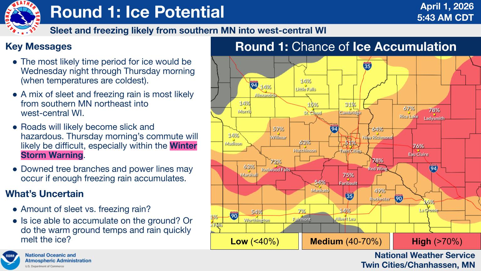
MINNEAPOLIS, MN — A Winter Weather Advisory is in effect for the Twin Cities and much of central and southern Minnesota as a messy spring storm brings a mix of sleet, freezing rain, and snow late Wednesday into Thursday.
Forecasters say the biggest concern is not snow, but ice and sleet that could make for hazardous travel, especially during the Thursday morning commute.
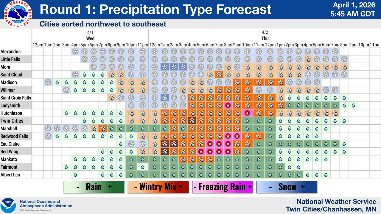
Precipitation is expected to begin as rain on Wednesday afternoon before transitioning to a wintry mix overnight.
Find out what's happening in Minneapolisfor free with the latest updates from Patch.
As temperatures drop, sleet and freezing rain will become more widespread, with the most impactful conditions likely between midnight and mid-morning Thursday.
Ice accumulations of up to two-tenths of an inch are possible in the advisory area, along with around a half inch of sleet and up to an inch of snow. Roads are expected to become slick and potentially dangerous, particularly during the morning drive.
Find out what's happening in Minneapolisfor free with the latest updates from Patch.
Higher ice totals, approaching a quarter inch, are possible in parts of eastern Minnesota and western Wisconsin. In those areas, forecasters warn of the potential for downed tree branches and isolated power outages.
Snowfall in the Twin Cities is expected to remain minimal, generally under an inch, with heavier snow more likely north of the metro.
All forms of wintry precipitation are possible with this system, and travel could become tricky at times through Thursday. Officials are urging drivers to slow down and use caution.
Today: A 20 percent chance of rain after 3pm. Cloudy, with a high near 48. East wind 10 to 15 mph.
Tonight: Rain, snow, and sleet before 2am, then snow and sleet between 2am and 4am, then sleet, possibly mixed with snow and freezing rain after 4am. The sleet could be heavy at times. Low around 31. East wind around 15 mph, with gusts as high as 30 mph. Chance of precipitation is 100%. New ice accumulation of less than a 0.1 of an inch possible. New snow and sleet accumulation of less than one inch possible.
Thursday: Rain, freezing rain, and sleet before 10am, then rain, possibly mixed with sleet between 10am and noon, then rain after noon. High near 35. East northeast wind 10 to 15 mph, with gusts as high as 25 mph. Chance of precipitation is 100%. New ice accumulation of less than a 0.1 of an inch possible. New sleet accumulation of less than a half inch possible.
Thursday Night: Rain likely, mainly before 7pm. Cloudy, with a low around 29. Northwest wind around 10 mph. Chance of precipitation is 60%.
Friday: A slight chance of freezing rain before 10am, then rain showers likely. Some thunder is also possible. Mostly cloudy, with a high near 42. Northeast wind 5 to 10 mph. Chance of precipitation is 70%. Little or no ice accumulation expected.
Friday Night: Rain showers before 5am, then rain likely, possibly mixed with snow showers. Some thunder is also possible. Low around 33. Northeast wind 10 to 15 mph becoming north northwest after midnight. Chance of precipitation is 80%. Little or no snow accumulation expected.
Saturday: Rain and snow showers likely, mainly after 1pm. Mostly cloudy, with a high near 39. West northwest wind 10 to 15 mph, with gusts as high as 25 mph. Chance of precipitation is 60%. New precipitation amounts of less than a tenth of an inch possible.
Saturday Night: A 20 percent chance of snow showers before 1am. Mostly cloudy, with a low around 27. Northwest wind around 15 mph, with gusts as high as 25 mph.
Sunday: Sunny, with a high near 45. West northwest wind around 10 mph.
Sunday Night: Mostly cloudy, with a low around 31. West northwest wind 5 to 10 mph.
Monday: A chance of rain and snow showers. Partly sunny, with a high near 45. West wind 5 to 10 mph becoming north in the afternoon. Chance of precipitation is 40%.
Monday Night: Mostly cloudy, with a low around 27. North wind 5 to 10 mph.
Tuesday: Mostly sunny, with a high near 47. North northeast wind 5 to 10 mph becoming south southeast in the afternoon.
Get more local news delivered straight to your inbox. Sign up for free Patch newsletters and alerts.


