Weather
MN Weather: How Hot Will It Get Thursday?
There will be an elevated risk of heat illness for people spending time outdoors Thursday, the National Weather Service warned.

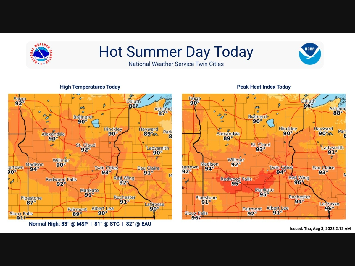
MINNEAPOLIS — Thursday will be hot and muggy, with a high of 93 degrees and a heat index in the mid-90s, according to the latest forecast.
There will be an elevated risk of heat illness for people spending time outdoors Thursday, the National Weather Service warned.
"Temperatures in the low 90s and heat index in the mid 90s will mark a 10 degree above normal day that we see a few times a summer today," the NWS said. "A slight chance for a few showers slides through this afternoon, otherwise partly cloudy."
Find out what's happening in Minneapolisfor free with the latest updates from Patch.
Air quality is expected to be "moderate" in the eastern Twin Cities metro area and "good" for the rest of the region and state Thursday.
Here's the specific NWS forecast from the Minneapolis-St. Paul Airport:
Find out what's happening in Minneapolisfor free with the latest updates from Patch.
Thursday: Mostly sunny and hot, with a high near 93. West southwest wind around 5 mph becoming northwest in the afternoon.
Thursday Night: Partly cloudy, with a low around 69. North northwest wind 5 to 10 mph becoming northeast after midnight.
Friday: Mostly sunny, with a high near 89. East wind 5 to 10 mph.
Friday Night: A 20 percent chance of showers and thunderstorms after 2am. Mostly cloudy, with a low around 68. East wind 5 to 10 mph.
Saturday: A 40 percent chance of showers and thunderstorms, mainly after 2pm. Mostly cloudy, with a high near 82. East southeast wind 10 to 15 mph.
Saturday Night: A chance of showers and thunderstorms, then showers likely and possibly a thunderstorm after 2am. Mostly cloudy, with a low around 66. East wind around 15 mph, with gusts as high as 25 mph. Chance of precipitation is 70%. New rainfall amounts between 1 and 2 inches possible.
Sunday: Showers likely and possibly a thunderstorm. Mostly cloudy, with a high near 77. Northeast wind around 15 mph. Chance of precipitation is 70%. New rainfall amounts between three quarters and one inch possible.
Sunday Night: Showers likely and possibly a thunderstorm before 8pm, then a chance of showers and thunderstorms between 8pm and 2am, then a slight chance of showers after 2am. Mostly cloudy, with a low around 62. North wind around 15 mph. Chance of precipitation is 70%.
Monday: A 20 percent chance of showers before 8am. Mostly sunny, with a high near 81. North northwest wind around 15 mph, with gusts as high as 25 mph.
Monday Night: Partly cloudy, with a low around 61. North northwest wind 10 to 15 mph.
Tuesday: Sunny, with a high near 82. West northwest wind 10 to 15 mph.
Tuesday Night: Mostly clear, with a low around 62. Southwest wind around 10 mph.
Wednesday: A 20 percent chance of showers. Mostly sunny, with a high near 82. South wind around 10 mph.
Get more local news delivered straight to your inbox. Sign up for free Patch newsletters and alerts.


