Weather
MN Weather: How Long Will The Heat Wave Last?
Temperatures will bounce around in the 90s this week, reaching 99 degrees on Wednesday.

TWIN CITIES, MN — A mid-August heatwave will arrive Saturday across central Minnesota, including the Twin Cities metro area. Temperatures will bounce around in the 90s this week, reaching 99 degrees on Wednesday. The high on Thursday is 89 degrees.
"High temperatures on Saturday will be in the 90s across central and southern Minnesota and western Wisconsin," the National Weather Service said.
"Dew points in the afternoon are expected to be in the mid 60s to lower 70s, resulting in a heat index of 95 to 100 in much of central and southern Minnesota, and 90 to 95 in western Wisconsin. Sunday will be a little cooler, then hot weather returns Monday. The heat intensifies Tuesday and Wednesday, when highs mostly in the mid and upper 90s. Some locations in southern Minnesota may even have high temperatures of 100."
Find out what's happening in Minneapolisfor free with the latest updates from Patch.
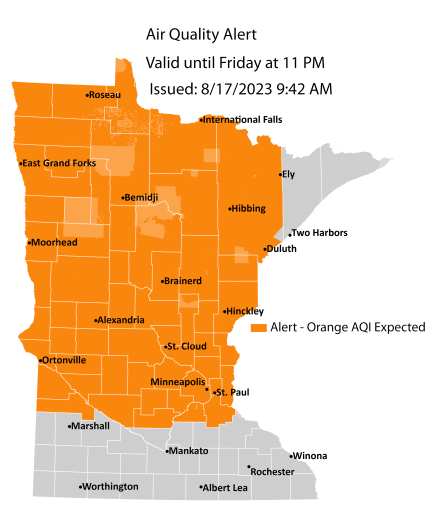
Meanwhile, an air quality alert continues through Friday night.
Here's the specific NWS forecast from the Minneapolis-St. Paul Airport:
Find out what's happening in Minneapolisfor free with the latest updates from Patch.
Friday: Widespread haze before 1pm. Mostly sunny, with a high near 83. South wind 5 to 10 mph increasing to 10 to 15 mph in the afternoon.
Friday Night: Mostly clear, with a low around 69. Breezy, with a south wind 15 to 20 mph, with gusts as high as 30 mph.
Saturday: Sunny and hot, with a high near 95. South southwest wind around 15 mph, with gusts as high as 25 mph.
Saturday Night: Mostly clear, with a low around 71. West wind around 10 mph becoming north after midnight.
Sunday: Mostly sunny, with a high near 87. North northeast wind 10 to 15 mph.
Sunday Night: Mostly cloudy, with a low around 67. Northeast wind 10 to 15 mph.
Monday: Partly sunny, with a high near 91. East southeast wind around 15 mph.
Monday Night: Partly cloudy, with a low around 72. East southeast wind around 15 mph.
Tuesday: Mostly sunny and hot, with a high near 97. East southeast wind 10 to 15 mph.
Tuesday Night: Mostly clear, with a low around 73. East southeast wind 10 to 15 mph.
Wednesday: Sunny and hot, with a high near 99. South southeast wind 10 to 15 mph becoming southwest in the afternoon.
Wednesday Night: Mostly clear, with a low around 71. West southwest wind 10 to 15 mph becoming north northwest after midnight.
Thursday: Mostly sunny, with a high near 89. North northwest wind 10 to 15 mph.
Get more local news delivered straight to your inbox. Sign up for free Patch newsletters and alerts.


