Weather
NWS Issues Severe Thunderstorm Watch For Minneapolis-St. Paul Area
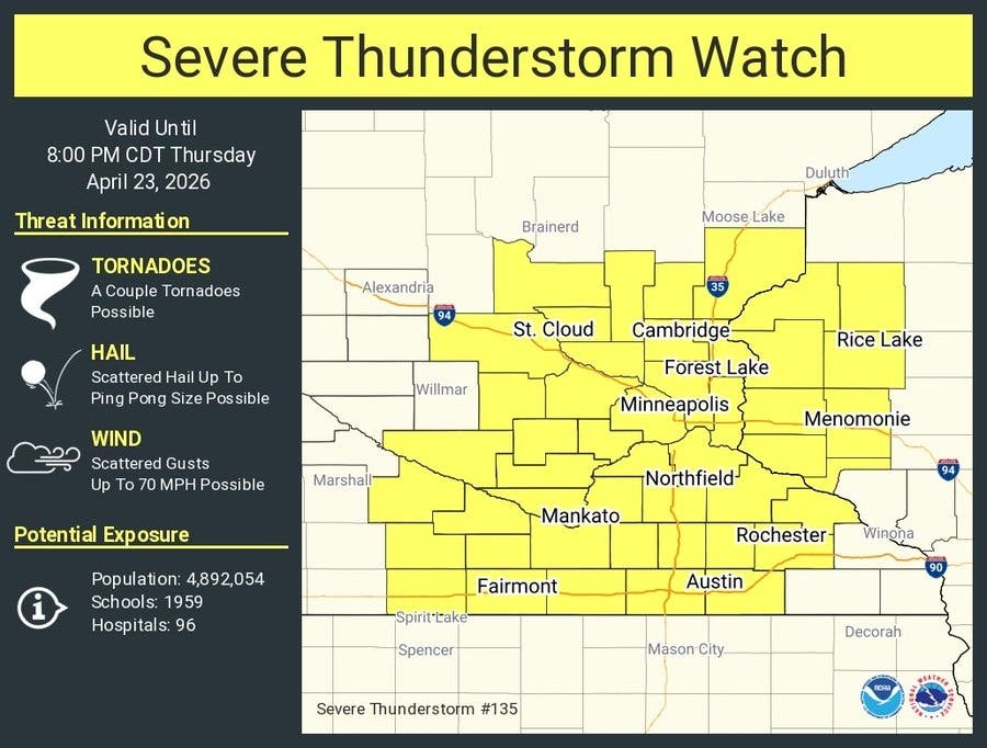
Damaging winds are the main concern Thursday afternoon and evening, though hail and a tornado are also possible.

MINNEAPOLIS, MN — A severe thunderstorm watch has been issued for the Twin Cities and a large stretch of Minnesota as forecasters warn strong to severe storms could develop Thursday afternoon and evening.
The watch, issued by the National Weather Service's Storm Prediction Center, is in effect until 8 p.m. and includes Hennepin, Ramsey, Dakota, Anoka, Washington, Scott and Carver counties, along with many other parts of central, eastern and southern Minnesota.
The NWS said strong to severe thunderstorms remain possible through this evening, especially in southern and eastern Minnesota and western Wisconsin.
Find out what's happening in Minneapolisfor free with the latest updates from Patch.
Damaging winds are the primary threat, with hail and a tornado also possible.
This Afternoon
Find out what's happening in Minneapolisfor free with the latest updates from Patch.
Showers and possibly a thunderstorm. Some of the storms could be severe. High near 72. Breezy, with a south wind 15 to 20 mph, with gusts as high as 30 mph. Chance of precipitation is 80%. New rainfall amounts between a quarter and half of an inch possible.
Here's the full NWS forecast from the Minneapolis-St. Paul Airport:
Tonight
Showers and thunderstorms likely before 11pm, then a slight chance of showers between 11pm and 1am. Some of the storms could be severe. Cloudy, then gradually becoming partly cloudy, with a low around 44. South wind 10 to 15 mph becoming west northwest after midnight. Chance of precipitation is 60%. New precipitation amounts between a tenth and quarter of an inch, except higher amounts possible in thunderstorms.
Friday
Sunny, with a high near 61. Northwest wind 10 to 15 mph.
Friday Night
Increasing clouds, with a low around 43. North northwest wind around 5 mph.
Saturday
Mostly cloudy, with a high near 62. North northeast wind around 5 mph becoming east in the afternoon.
Saturday Night
A 20 percent chance of showers. Mostly cloudy, with a low around 47. East wind 5 to 10 mph.
Sunday
A 20 percent chance of showers after 1pm. Partly sunny, with a high near 67. East southeast wind 10 to 15 mph.
Sunday Night
A chance of showers, then showers likely and possibly a thunderstorm after 1am. Mostly cloudy, with a low around 51. Breezy, with an east southeast wind 10 to 20 mph, with gusts as high as 30 mph. Chance of precipitation is 70%.
Monday
Showers, with thunderstorms also possible after 1pm. High near 61. Breezy, with an east southeast wind 15 to 20 mph, with gusts as high as 35 mph. Chance of precipitation is 90%.
Monday Night
Showers likely, mainly before 1am. Mostly cloudy, with a low around 43. Breezy, with a southeast wind 15 to 20 mph becoming west after midnight. Winds could gust as high as 30 mph. Chance of precipitation is 60%.
Tuesday
A 30 percent chance of showers. Partly sunny, with a high near 55. Breezy, with a west northwest wind 15 to 20 mph, with gusts as high as 30 mph.
Tuesday Night
Partly cloudy, with a low around 38. West northwest wind 5 to 15 mph.
Wednesday
Mostly sunny, with a high near 56. West northwest wind 5 to 10 mph.
Get more local news delivered straight to your inbox. Sign up for free Patch newsletters and alerts.


