Weather
Rain Starts Thursday Morning Before Snow Moves In: MN Weather
Here's what to expect as another winter storm system moves into the Twin Cities metro area Thursday.


TWIN CITIES, MN — The National Weather Service's winter weather advisory has been expanded and now includes the Twin Cities metro area, the Interstate 35 corridor in southern Minnesota, and everything west of that.
However, projected snowfall totals have fallen because more of it will just be rain. Still, up to 4 inches of new snow could pile up when all is said in done.
"Blowing snow and a several inches of accumulation are expected, with rain to begin with early this morning," the NWS said.
Find out what's happening in Minneapolisfor free with the latest updates from Patch.
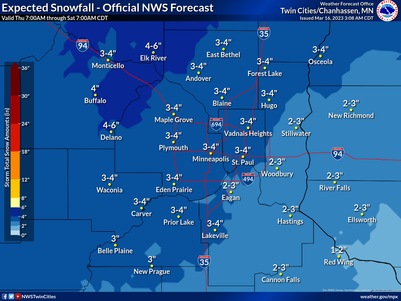
Here's the specific NWS forecast from the Minneapolis-St. Paul Airport:
Thursday: Rain before 3pm, then snow and sleet, possibly mixed with rain between 3pm and 4pm, then snow after 4pm. Patchy blowing snow after 5pm. Temperature falling to around 30 by 5pm. Breezy, with a north wind 5 to 10 mph becoming north northwest 15 to 20 mph in the afternoon. Winds could gust as high as 35 mph. Chance of precipitation is 100%. Total daytime snow and sleet accumulation of 1 to 2 inches possible.
Find out what's happening in Minneapolisfor free with the latest updates from Patch.
Thursday Night: Snow, mainly before 9pm. Patchy blowing snow. Low around 14. Blustery, with a northwest wind 20 to 25 mph, with gusts as high as 40 mph. Chance of precipitation is 100%. New snow accumulation of 1 to 3 inches possible.
Friday: Patchy blowing snow before 8am, then patchy blowing snow after 3pm. Mostly cloudy, with a high near 19. Blustery, with a northwest wind 15 to 20 mph, with gusts as high as 30 mph.
Friday Night: A 20 percent chance of snow before 8pm. Patchy blowing snow before 4am. Mostly cloudy, with a low around 11. Blustery, with a west northwest wind around 20 mph, with gusts as high as 35 mph.
Saturday: Mostly cloudy, with a high near 23. Blustery, with a northwest wind around 20 mph, with gusts as high as 30 mph.
Saturday Night: Partly cloudy, with a low around 8. Blustery, with a west northwest wind 10 to 20 mph, with gusts as high as 25 mph.
Sunday: Sunny, with a high near 29. West wind 10 to 15 mph.
Sunday Night: Mostly clear, with a low around 18. Southwest wind 10 to 15 mph.
Monday: Mostly sunny, with a high near 39. South southwest wind around 10 mph.
Monday Night: A 20 percent chance of snow after 2am. Partly cloudy, with a low around 27. South wind around 10 mph.
Tuesday: A slight chance of rain, snow, and freezing rain. Partly sunny, with a high near 43. South southeast wind around 10 mph. Chance of precipitation is 20%.
Tuesday Night: A 30 percent chance of rain. Mostly cloudy, with a low around 31. Southeast wind around 10 mph.
Wednesday: A 50 percent chance of rain. Partly sunny, with a high near 46. Southeast wind around 15 mph.
Get more local news delivered straight to your inbox. Sign up for free Patch newsletters and alerts.


