Weather
Several Chances For Light Snow Are Coming Up: MN Weather
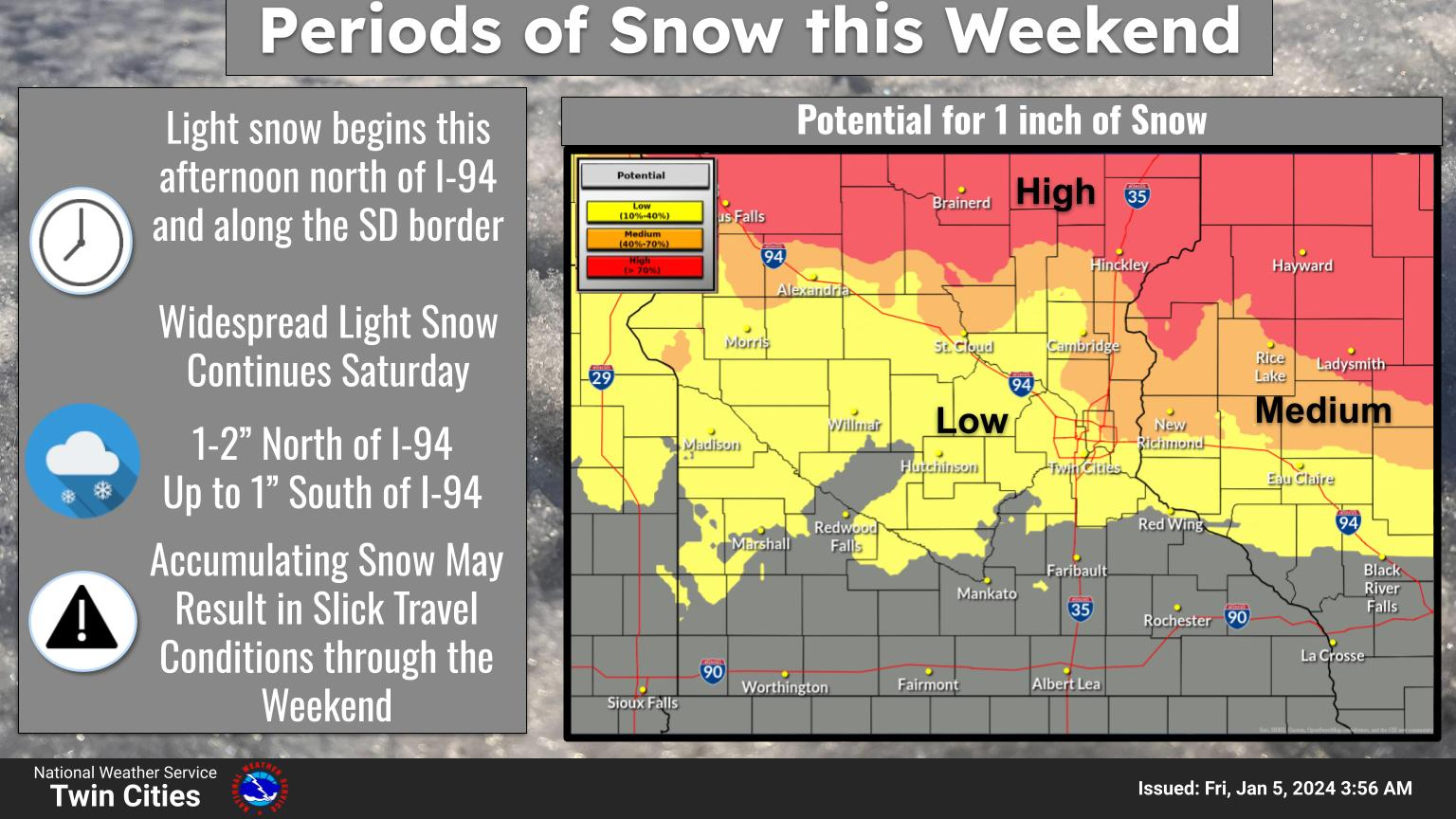
The latest forecast shows that up to an inch of new snow could accumulate by Sunday afternoon, and even more in areas north of I-94.


MINNEAPOLIS — Snow lovers have reason to hope that winter might arrive in Minnesota sometime this month. The region will see several decent chances for snow coming up, though don't expect anything big enough to warrant a snow emergency or widespread school closures.
The latest forecast shows that up to an inch of new snow could accumulate by Sunday afternoon, and even more in areas north of Interstate 94.
"Through next weekend, there will be the potential for three or four opportunities for seeing accumulating snowfall," the National Weather Service said.
Find out what's happening in Minneapolisfor free with the latest updates from Patch.
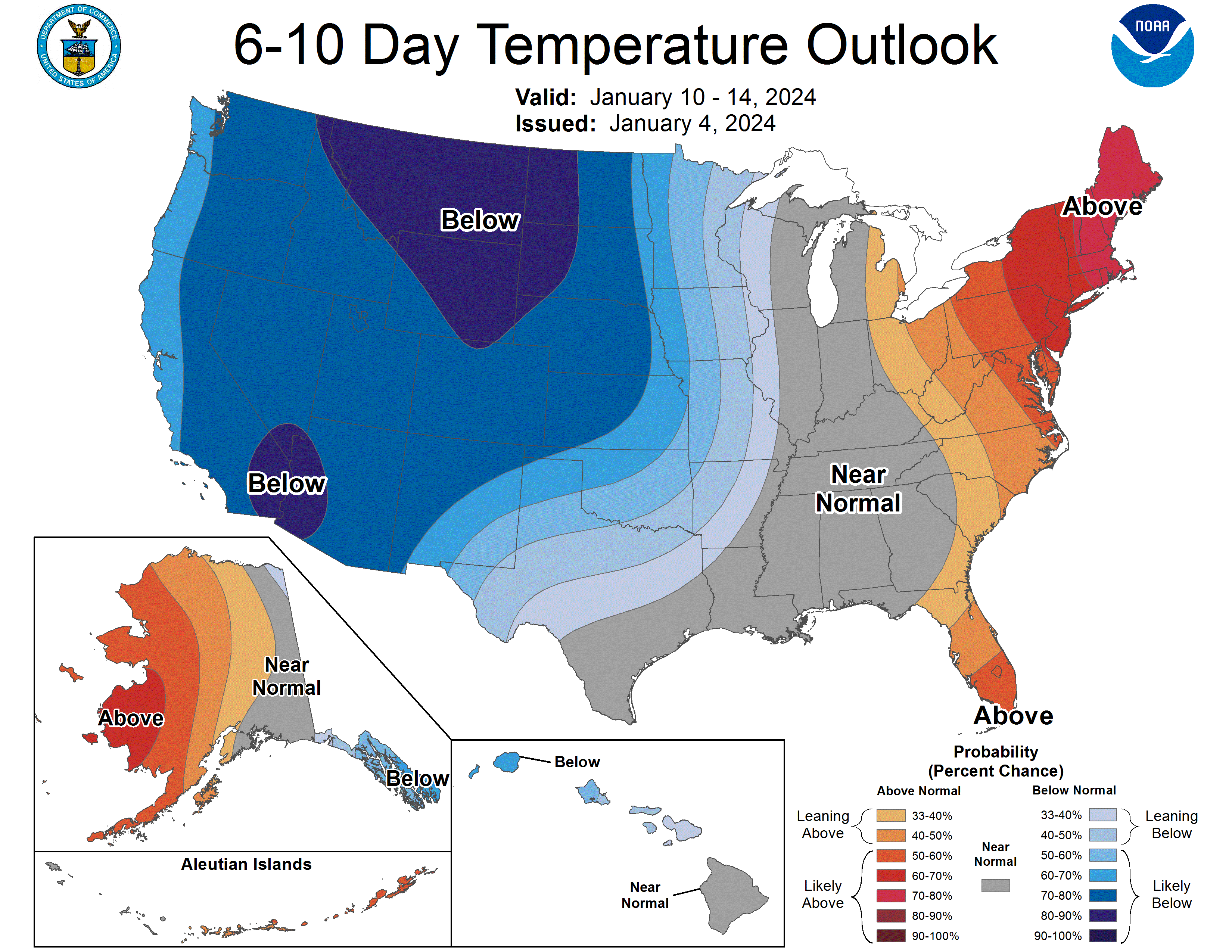
"Based on what we've seen so far this winter, the forecast may look cold, but we'll continue to run 5 to 10 degrees above normal through the middle of next week."
Meanwhile, temperatures may become relatively cold over the next 10 days.
Find out what's happening in Minneapolisfor free with the latest updates from Patch.
Here's the specific NWS forecast from the Minneapolis-St. Paul Airport. Days or evenings in bold feature chances for snow:
Friday: A chance of flurries with a slight chance of snow before 2pm, then a chance of flurries between 2pm and 4pm, then a slight chance of snow after 4pm. Cloudy, with a high near 34. South wind around 10 mph. Chance of precipitation is 20%.
Friday Night: Snow likely, mainly between 9pm and 10pm. Cloudy, with a low around 27. South wind 5 to 10 mph. Chance of precipitation is 60%. New snow accumulation of less than a half inch possible.
Saturday: A chance of flurries before 9am, then snow likely, mainly after noon. Cloudy, with a high near 34. South wind 5 to 10 mph becoming west in the afternoon. Chance of precipitation is 70%. Little or no snow accumulation expected.
Saturday Night: Snow likely, mainly before midnight. Cloudy, with a low around 22. Northwest wind 5 to 10 mph. Chance of precipitation is 60%. New snow accumulation of less than a half inch possible.
Sunday: Partly sunny, with a high near 26. Northwest wind 5 to 10 mph.
Sunday Night: Mostly cloudy, with a low around 19. North northwest wind around 5 mph becoming east after midnight.
Monday: A 20 percent chance of snow after noon. Mostly cloudy, with a high near 29. East wind 5 to 10 mph.
Monday Night: A 30 percent chance of snow, mainly before midnight. Mostly cloudy, with a low around 21. East northeast wind 5 to 10 mph.
Tuesday: Partly sunny, with a high near 29. North northeast wind around 10 mph.
Tuesday Night: Mostly cloudy, with a low around 20. North northwest wind around 10 mph.
Wednesday: Mostly cloudy, with a high near 28. West southwest wind around 10 mph.
Wednesday Night: A 30 percent chance of snow. Mostly cloudy, with a low around 16. Northwest wind 10 to 15 mph.
Thursday: A 30 percent chance of snow. Mostly cloudy, with a high near 22. North northwest wind around 15 mph.
Get more local news delivered straight to your inbox. Sign up for free Patch newsletters and alerts.


