Weather
Severe Storms, Tornado Risk Target Minnesota Monday Afternoon
All severe weather threats are possible, including 70 mph winds, large hail, and tornadoes, with risk tied to a shifting warm front.

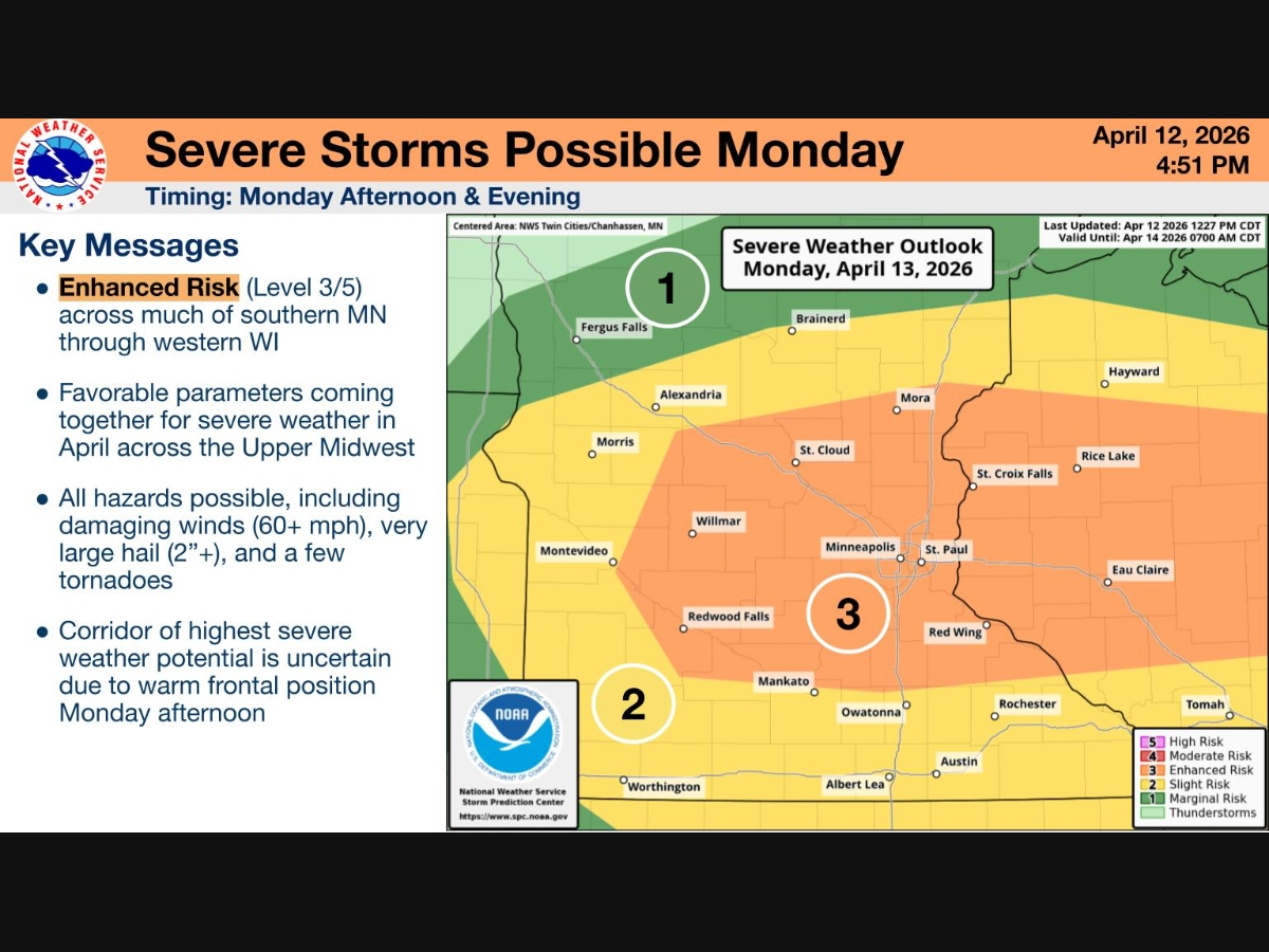
MINNEAPOLIS, MN — Severe storms capable of producing tornadoes, very large hail, and damaging winds are expected to develop Monday afternoon and evening across southern Minnesota and western Wisconsin.
The National Weather Service says the region faces an enhanced risk for severe weather, with conditions supportive of supercells, storms that can rotate and quickly become dangerous.
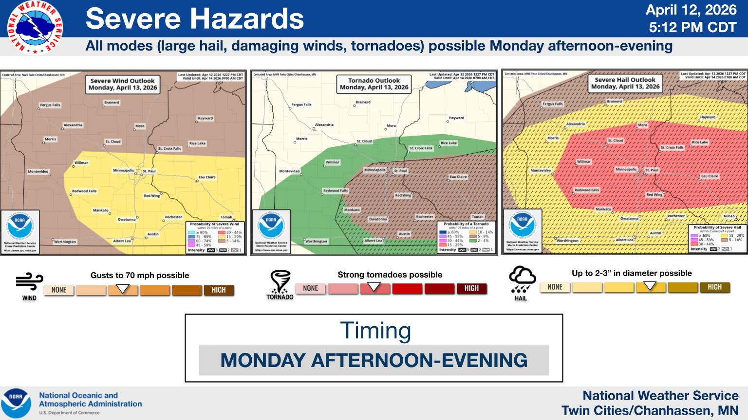
Forecasters say storms are likely to develop between 4 p.m. and 6 p.m., with the potential to intensify rapidly. All hazards are possible, including wind gusts up to 70 mph, hail as large as 2 to 3 inches in diameter, and a few strong tornadoes.
Find out what's happening in Minneapolisfor free with the latest updates from Patch.
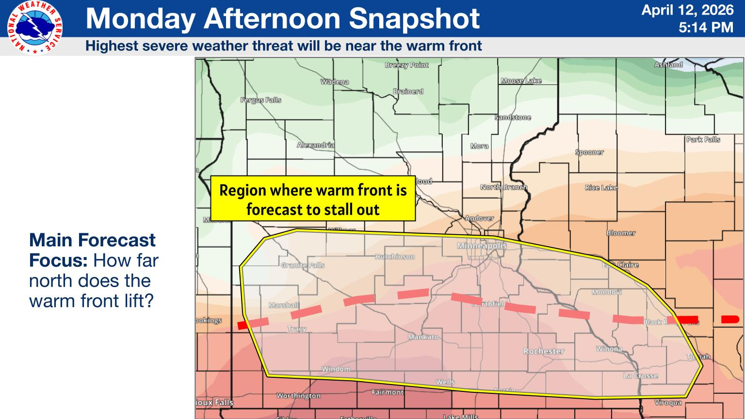
The greatest uncertainty, and the key to where the worst weather occurs, is the position of a warm front expected to stall somewhere across southern Minnesota.
As of Sunday, that boundary could be set up anywhere between Interstate 94 and Interstate 90. Areas along and just south of the front will have the highest risk, particularly for tornadoes, as storms are expected to begin rotating soon after forming.
Find out what's happening in Minneapolisfor free with the latest updates from Patch.
Forecasters caution that even small shifts in the warm front’s position could significantly change which communities see the most severe weather.
Residents are urged to stay weather-aware Monday afternoon and evening and be prepared to take shelter quickly if warnings are issued.
Here's the full NWS forecast from the Minneapolis-St. Paul Airport:
Monday: A slight chance of showers, then showers and thunderstorms likely after 4pm. Partly sunny, with a high near 74. North northeast wind 5 to 10 mph becoming east southeast in the afternoon. Chance of precipitation is 60%. New rainfall amounts between a tenth and quarter of an inch, except higher amounts possible in thunderstorms.
Monday Night: Showers and thunderstorms likely before 11pm, then a slight chance of showers between 11pm and 2am. Mostly cloudy, with a low around 52. Southeast wind 5 to 10 mph becoming north northwest after midnight. Chance of precipitation is 60%. New precipitation amounts between a tenth and quarter of an inch, except higher amounts possible in thunderstorms.
Tuesday: A 30 percent chance of showers after 1pm. Partly sunny, with a high near 69. West northwest wind around 5 mph.
Tuesday Night: A 40 percent chance of showers, mainly before 1am. Partly cloudy, with a low around 47. Northeast wind 5 to 10 mph.
Wednesday: A 50 percent chance of showers, mainly after 1pm. Partly sunny, with a high near 69. East wind 5 to 10 mph. New precipitation amounts of less than a tenth of an inch possible.
Wednesday Night: A 40 percent chance of showers and thunderstorms. Mostly cloudy, with a low around 50. East northeast wind around 5 mph.
Thursday: A 20 percent chance of showers before 1pm. Mostly sunny, with a high near 73. North wind 5 to 10 mph becoming south in the afternoon.
Thursday Night: A 20 percent chance of showers after 1am. Mostly clear, with a low around 56. South southeast wind around 10 mph.
Friday: A chance of showers, then showers likely and possibly a thunderstorm after 1pm. Partly sunny, with a high near 70. South southeast wind 10 to 15 mph becoming west in the afternoon. Winds could gust as high as 30 mph. Chance of precipitation is 60%.
Friday Night: A chance of rain and snow showers. Mostly cloudy, with a low around 34. North northwest wind 10 to 15 mph, with gusts as high as 25 mph. Chance of precipitation is 40%.
Saturday: A chance of rain and snow showers. Partly sunny, with a high near 46. Northwest wind 10 to 15 mph. Chance of precipitation is 40%.
Saturday Night: A chance of rain and snow showers. Partly cloudy, with a low around 32. Northwest wind 5 to 10 mph. Chance of precipitation is 30%.
Sunday: A slight chance of rain and snow showers. Mostly sunny, with a high near 53. West wind 5 to 10 mph. Chance of precipitation is 20%.
Get more local news delivered straight to your inbox. Sign up for free Patch newsletters and alerts.


