Weather
Snow Timing In Twin Cities: Here’s What’s Changed Since Yesterday
Main snow window still Wednesday night, but the system stretches into the weekend.

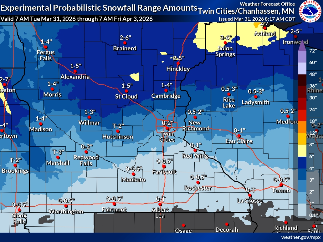
MINNEAPOLIS, MN — The latest forecast is sharpening the timing for this week’s snow in the Twin Cities, with the most impactful window still expected Wednesday night.
After a quiet Tuesday, precipitation arrives Wednesday afternoon as a rain-snow mix. Little accumulation is expected during the day, but conditions are expected to shift more toward snow into the evening.
What’s changed?
Find out what's happening in Minneapolisfor free with the latest updates from Patch.
Forecasters are now emphasizing a longer stretch of unsettled weather rather than a quick-hit system.
Snow on Wednesday night remains the best chance for accumulation, with around an inch possible. That could create slick roads during the Thursday morning commute.
Find out what's happening in Minneapolisfor free with the latest updates from Patch.
Beyond that, the system lingers.
Thursday still looks messy, with snow mixing with rain and limiting additional accumulation. But instead of clearing out quickly, off-and-on chances for snow and a wintry mix now extend into Friday and Saturday.
The bottom line:
The totals remain light, but the duration is longer. This is shaping up less like a single snow event and more like several rounds of nuisance snow and slush over multiple days.
That means travel impacts may come in waves, especially Wednesday night into Thursday, with additional minor issues possible later in the week.
Here's the full NWS forecast from the Minneapolis-St. Paul Airport:
Today: Mostly cloudy, with a high near 50. North northwest wind around 15 mph, with gusts as high as 25 mph.
Tonight: Mostly cloudy, with a low around 32. North northwest wind 10 to 15 mph becoming northeast after midnight.
Wednesday: A slight chance of rain and snow before 1pm, then a chance of snow between 1pm and 3pm, then rain and snow likely after 3pm. Mostly cloudy, with a high near 42. East wind 10 to 15 mph. Chance of precipitation is 60%. Little or no snow accumulation expected.
Wednesday Night: Snow showers, possibly mixed with rain. Low around 31. East wind around 15 mph. Chance of precipitation is 90%. New snow accumulation of around an inch possible.
Thursday: Rain, possibly mixed with snow showers, becoming all rain after 4pm. High near 39. East northeast wind around 15 mph. Chance of precipitation is 90%. New snow accumulation of less than one inch possible.
Thursday Night: A chance of rain and snow showers before 8pm, then a chance of rain showers between 8pm and 1am. Cloudy, then gradually becoming partly cloudy, with a low around 28. North wind around 10 mph. Chance of precipitation is 30%.
Friday: A slight chance of snow showers before 10am, then a chance of rain showers. Mostly cloudy, with a high near 44. North wind 5 to 10 mph becoming east northeast in the afternoon. Chance of precipitation is 50%.
Friday Night: Rain showers likely before 4am, then rain and snow showers likely. Mostly cloudy, with a low around 35. Northeast wind around 10 mph. Chance of precipitation is 70%.
Saturday: Rain and snow showers likely, becoming all rain after 10am. Mostly cloudy, with a high near 43. North wind 10 to 15 mph. Chance of precipitation is 60%.
Saturday Night: A chance of rain showers before 8pm, then a chance of rain and snow showers between 8pm and 10pm, then a chance of snow showers after 10pm. Mostly cloudy, with a low around 30. Northwest wind 10 to 15 mph. Chance of precipitation is 30%.
Sunday: A 20 percent chance of snow showers. Mostly sunny, with a high near 46. Northwest wind 10 to 15 mph.
Sunday Night: Partly cloudy, with a low around 30. Northwest wind 5 to 10 mph becoming southwest after midnight.
Monday: A slight chance of rain and snow showers. Partly sunny, with a high near 48. Southwest wind 5 to 10 mph. Chance of precipitation is 20%.
Get more local news delivered straight to your inbox. Sign up for free Patch newsletters and alerts.


