Weather
Snow Wednesday Morning, More Possible This Weekend: MN Weather
"Look for snow to overspread much of the Twin Cities metro area by 8:30 a.m.," the National Weather Service said.


TWIN CITIES, MN — Commuters in the Twin Cities metro area and across central Minnesota should expect some snow Wednesday morning.
"Look for snow to overspread much of the Twin Cities metro area by 8:30 a.m.," the National Weather Service said. "The snow will taper off later this morning, after dropping amounts from a trace (south metro) to around 1.5 inches (north metro).
The NWS said that visibilities of a mile or less could take place on the roads. "Slow down and allow yourself extra time for your morning commute," weather officials warned.
Find out what's happening in Minneapolisfor free with the latest updates from Patch.
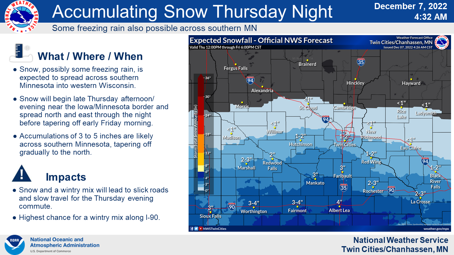
More snow is in the forecast for Thursday and this weekend:
Here's the full NWS forecast from the Minneapolis-St. Paul Airport:
Find out what's happening in Minneapolisfor free with the latest updates from Patch.
Wednesday: Snow, mainly before 11am. High near 19. North northeast wind 5 to 10 mph. Chance of precipitation is 80%. Total daytime snow accumulation of less than one inch possible.
Wednesday Night: Mostly clear, with a low around 12. North northeast wind around 5 mph becoming calm in the evening.
Thursday: Mostly sunny, with a high near 30. Southeast wind 5 to 10 mph.
Thursday Night: Snow likely, mainly after midnight. Mostly cloudy, with a low around 26. East wind 5 to 10 mph. Chance of precipitation is 70%. New snow accumulation of 1 to 2 inches possible.
Friday: A 40 percent chance of snow before noon. Mostly cloudy, with a high near 35. East wind around 10 mph.
Friday Night: A slight chance of freezing drizzle. Mostly cloudy, with a low around 30. East southeast wind 5 to 10 mph.
Saturday: A chance of snow and freezing drizzle before 1pm, then a slight chance of rain and snow between 1pm and 5pm, then a slight chance of snow after 5pm. Cloudy, with a high near 36. Southeast wind 5 to 10 mph. Chance of precipitation is 40%.
Saturday Night: Mostly cloudy, with a low around 29. Southeast wind around 5 mph becoming calm after midnight.
Sunday: Mostly cloudy, with a high near 36. South southeast wind 5 to 10 mph.
Sunday Night: Mostly cloudy, with a low around 29. Southeast wind 5 to 10 mph.
Monday: A chance of rain, snow, and freezing rain. Mostly cloudy, with a high near 38. Southeast wind 10 to 15 mph. Chance of precipitation is 40%.
Monday Night: Rain and snow likely. Cloudy, with a low around 33. East southeast wind around 15 mph. Chance of precipitation is 70%.
Tuesday: Rain and snow. High near 40. East southeast wind around 15 mph, with gusts as high as 25 mph. Chance of precipitation is 80%.
Get more local news delivered straight to your inbox. Sign up for free Patch newsletters and alerts.


