Weather
Possible Record-Breaking Winter Storm Barrels Down On Twin Cities: Latest Forecast
Snowfall estimates have increased as a major winter storm takes aim at Minnesota. Blizzard conditions could also snarl travel.

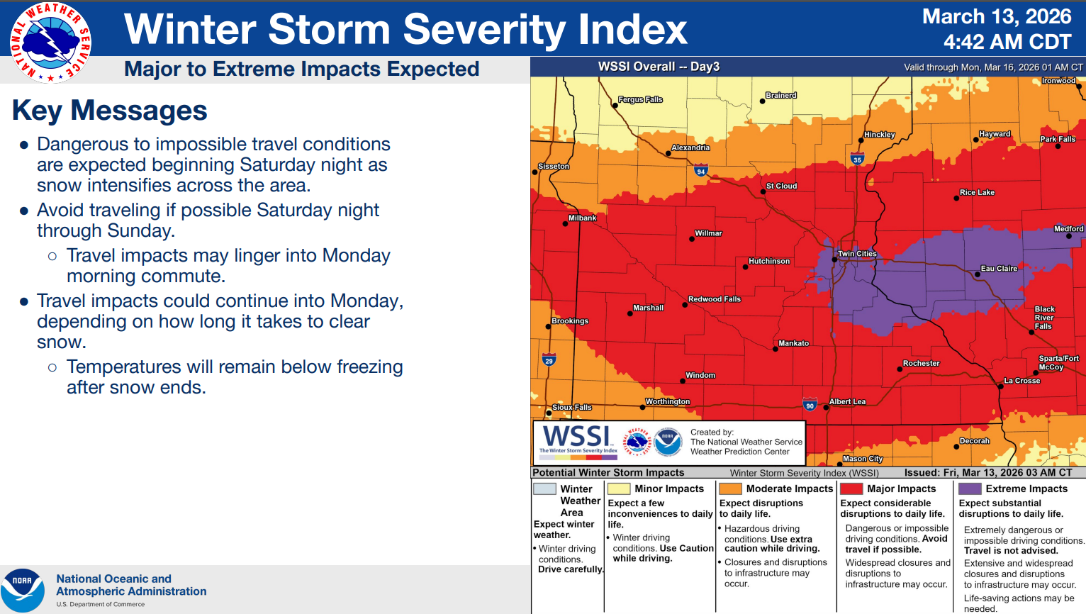
A major winter storm that could become one of the region's most significant on record will move across the Upper Midwest starting late Saturday through Sunday, potentially dropping up to 16 inches of snow on the Twin Cities metro and up to 20 inches in other parts of Minnesota.
A winter storm warning is now in effect from 7 p.m. Saturday until 7 a.m. Monday for much of central and southeastern Minnesota, including the Twin Cities, Morris, Alexandria, St. Cloud, Red Wing, Mankato and Albert Lea, according to the National Weather Service.
“This is shaping up to be one of the most expansive and impactful storms that the United States has experienced so far this year,” AccuWeather Senior Meteorologist John Feerick said Friday. “Millions of people could be impacted by travel delays, power outages, business shutdowns and school closures, even after the storm exits.”
Find out what's happening in Minneapolisfor free with the latest updates from Patch.
The storm is expected to strengthen as it moves from the Rockies into the Plains and Great Lakes from Saturday through Monday, interacting with an advancing surge of Arctic air, AccuWeather said in its latest forecast.
In Minnesota, the first concern is heavy snow. According to the National Weather Service, between 10 and 16 inches of snow could fall in the winter storm warning area, while a narrow swath could see 15 to 20 inches. Totals across portions of western and central Wisconsin could approach 2 feet.
Find out what's happening in Minneapolisfor free with the latest updates from Patch.
The Twin Cities have a 40-70% chance of seeing a foot or more of snow, the National Weather Service said. Southeastern Minnesota has more than a 70% chance.
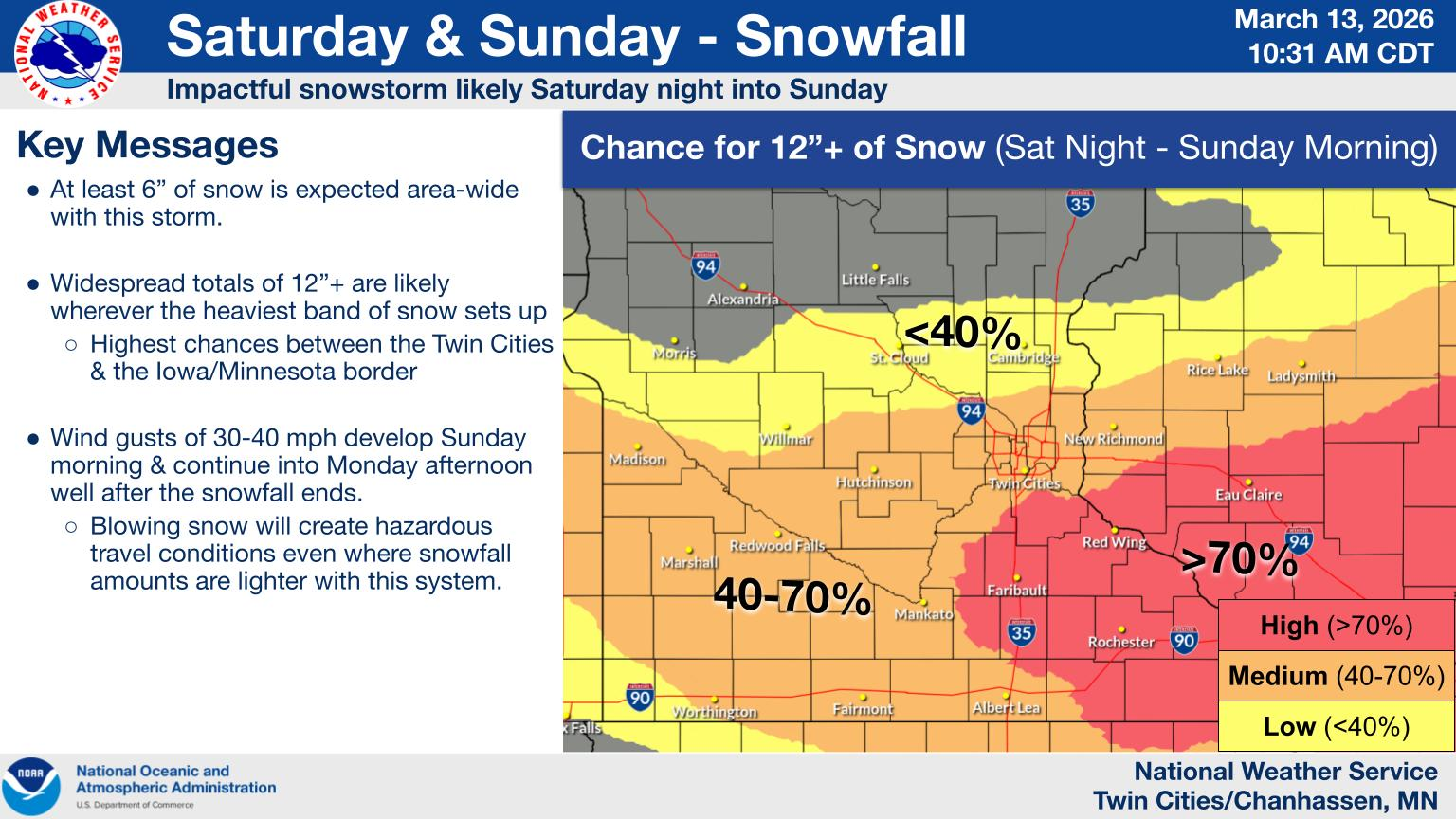
The heaviest snow will fall Saturday evening into the overnight hours, with rates of 2 inches per hour possible. Winds will also start to pick up out of the northeast at 20 to 30 mph.
The second concern will be increasing winds on Sunday, National Weather Service forecasters said. Even though the snow is expected to diminish on Sunday, northwest winds will increase to 35 to 45 mph.
The combination of heavy snow and gusty winds will reduce
visibility and create periods of blizzard conditions on Sunday across western and southern Minnesota," the National Weather Service wrote.
Travel is expected to become very difficult or impossible late
Saturday night and Sunday, forecasters said. Additionally, the amount of water in the snowpack will make it wet and very heavy, potentially damaging infrastructure and posing a health hazard for those shoveling.
March has brought the Twin Cities area some of its biggest snowstorms on record, according to the Minneapolis Star-Tribune, which said this storm could be one of the biggest on record for the metro. Others include the seventh-largest of all time with 16.7 inches on March 3-4, 1985, and March 11-14, 1940.
Delta Airlines on Friday said passengers traveling out of Minneapolis-St. Paul International Airport and several other Midwest airports can rebook their flights for no fee, provided the rebooked travel occurs on or before March 22.
Minnesota Youth Athletic Services also called off its Grade State basketball tournament Sunday games, moving all those contests to Saturday, the Star Tribune reported.
After the storm leaves the state, cooler weather should be expected, with low temperatures dipping below zero on Tuesday morning. Warmer temperatures return on Wednesday when highs reach the 40s, the National Weather Service said.
Here's a look at the detailed National Weather Service forecast for the Twin Cities:
Friday: Sunny, with a high near 36. Breezy, with a northwest wind 15 to 20 mph, with gusts as high as 30 mph.
Friday Night: Increasing clouds, with a low around 25. North northwest wind 5 to 10 mph becoming east after midnight.
Saturday: Snow likely, mainly after 1pm. Mostly cloudy, with a high near 37. Light southeast wind becoming east 5 to 10 mph in the morning. Chance of precipitation is 60%. New snow accumulation of less than one inch possible.
Saturday Night: Snow. The snow could be heavy at times. Patchy blowing snow after 1am. Low around 28. Blustery, with an east wind 15 to 20 mph, with gusts as high as 30 mph. Chance of precipitation is 100%. New snow accumulation of 7 to 11 inches possible.
Sunday: Snow. The snow could be heavy at times. Widespread blowing snow, mainly between 9am and 1pm. High near 32. Breezy, with a north wind 20 to 25 mph, with gusts as high as 40 mph. Chance of precipitation is 100%. New snow accumulation of 7 to 11 inches possible.
Sunday Night: A 50 percent chance of snow, mainly before 1am. Patchy blowing snow. Mostly cloudy, with a low around 8. Blustery, with a north northwest wind 20 to 25 mph, with gusts as high as 40 mph. New snow accumulation of 1 to 2 inches possible.
Monday: Patchy blowing snow between noon and 4pm. Mostly sunny, with a high near 18. Blustery, with a northwest wind around 20 mph, with gusts as high as 35 mph.
Monday Night: Mostly clear, with a low around -4. Northwest wind 5 to 15 mph.
Tuesday: A 30 percent chance of snow after 1pm. Mostly sunny, with a high near 23. West wind 5 to 10 mph becoming south in the afternoon.
Get more local news delivered straight to your inbox. Sign up for free Patch newsletters and alerts.


