Weather
Snowstorm Arrives, Bitter Cold Next: What's On Tap For The MN Weekend
Winter has finally arrived in Minnesota. Here's what the Twin Cities metro should expect as the storm barrels through.


TWIN CITIES, MN — Snowfall totals for Minnesota have shifted down somewhat since the storm arrived. However, the Twin Cities metro area should still expect 2 to 3 inches of new accumulation Friday evening through Saturday night.
"Light snow will slowly spread into central MN this evening," the National Weather Service said. "The snow will continue through Saturday with gusty winds causing travel impacts from blowing snow, especially across open areas. Arctic air leads to bitterly cold wind chills Saturday night through Tuesday."

"Dangerously wind cold wind chills develop Saturday night and continue into Tuesday. Wind chills as low as -30 to -40 degrees are expected Sunday & Monday morning," according to the NWS.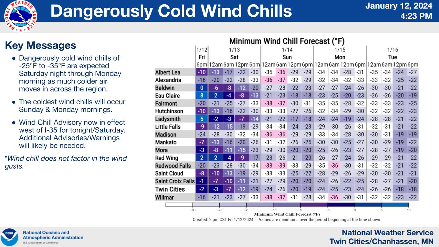
Find out what's happening in Minneapolisfor free with the latest updates from Patch.
Road conditions during the Friday evening commute will be far less than ideal. Be sure to slow down, wear your seatbelt, and drive with your headlights on at all times.
Here's the specific NWS forecast from the Minneapolis-St. Paul Airport:
Find out what's happening in Minneapolisfor free with the latest updates from Patch.
Friday Night: Snow. Low around 10. Blustery, with a north northwest wind 15 to 20 mph, with gusts as high as 30 mph. Chance of precipitation is 90%. New snow accumulation of 1 to 3 inches possible.
Saturday: Snow likely, mainly before noon. Cloudy, with a temperature falling to around 7 by 3pm. Wind chill values as low as -12. Blustery, with a northwest wind 15 to 20 mph, with gusts as high as 25 mph. Chance of precipitation is 70%. New snow accumulation of less than one inch possible.
Saturday Night: A 30 percent chance of snow before midnight. Mostly cloudy, with a low around -5. Wind chill values as low as -25. Blustery, with a northwest wind 15 to 20 mph, with gusts as high as 30 mph.
Sunday: Mostly cloudy and cold, with a high near 1. West northwest wind around 15 mph, with gusts as high as 25 mph.
Sunday Night: Mostly cloudy, with a low around -8. West wind 10 to 15 mph.
M.L.King Day: Partly sunny and cold, with a high near 1. Breezy, with a west wind 10 to 20 mph, with gusts as high as 30 mph.
Monday Night: Mostly cloudy, with a low around -8. Breezy, with a west wind 15 to 20 mph, with gusts as high as 30 mph.
Tuesday: Partly sunny and cold, with a high near 4. West wind around 15 mph.
Tuesday Night
Partly cloudy, with a low around -3. Southwest wind 10 to 15 mph.
Wednesday: Mostly cloudy, with a high near 13. West wind around 15 mph.
Wednesday Night: Mostly cloudy, with a low around 0. Northwest wind 10 to 15 mph.
Thursday: Mostly cloudy, with a high near 9. Northwest wind around 15 mph.
Thursday Night: Mostly cloudy, with a low around -2. West northwest wind around 15 mph.
Friday: Mostly cloudy, with a high near 9. West northwest wind around 15 mph, with gusts as high as 25 mph.
Get more local news delivered straight to your inbox. Sign up for free Patch newsletters and alerts.


