Weather
Snowstorm Will Arrive Late Thursday Morning In The Metro: MN Weather
Following Thursday's snow, another significant snowstorm is set to arrive Saturday afternoon.


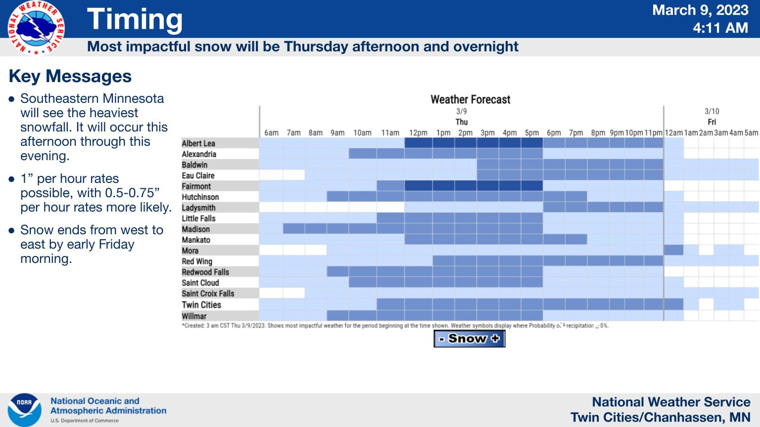
TWIN CITIES, MN — Commuters in the Twin Cities metro should prepare for a slow evening commute home on Thursday, thanks to the incoming snowstorm. Snow will arrive in the metro area late Thursday morning and last through the evening.
"The heaviest snow is expected this afternoon and evening," the National Weather Service said.
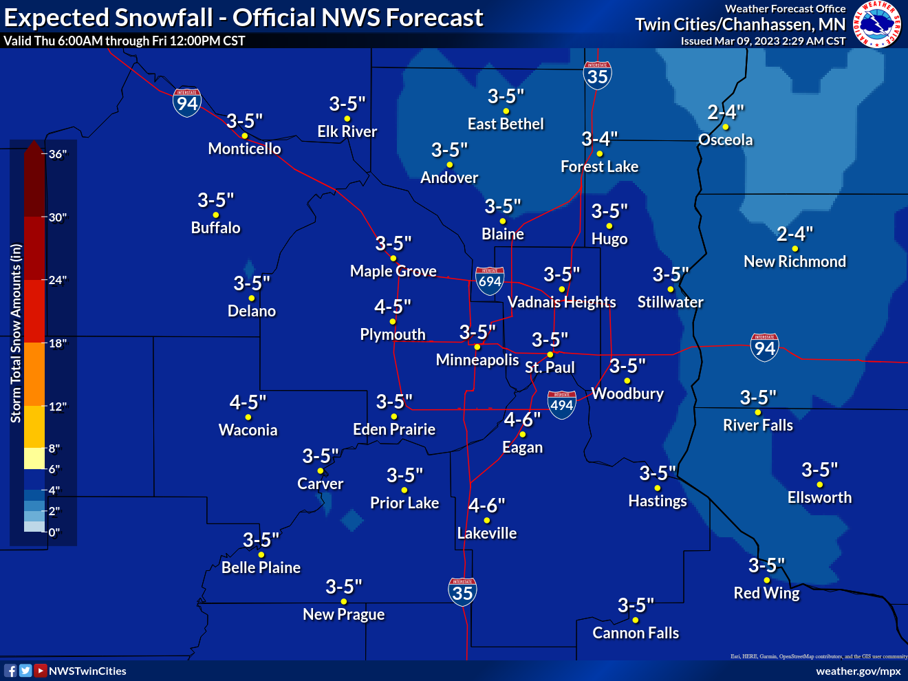
"Amounts greater than 6 inches are most likely across southeast Minnesota, where hourly snowfall rates will be a bit higher. The snow will get weaker Thursday night, and end by early Friday morning."
Find out what's happening in Minneapolisfor free with the latest updates from Patch.
Another significant snowstorm is set to arrive Saturday afternoon.
Here's the specific NWS forecast from the Minneapolis-St. Paul Airport:
Find out what's happening in Minneapolisfor free with the latest updates from Patch.
Thursday: Snow, mainly after 11am. High near 35. East wind 10 to 15 mph. Chance of precipitation is 90%. Total daytime snow accumulation of 1 to 3 inches possible.
Thursday Night: Snow, mainly before 3am. Low around 27. East northeast wind 5 to 15 mph. Chance of precipitation is 90%. New snow accumulation of 1 to 3 inches possible.
Friday: Mostly cloudy, with a high near 34. Northeast wind around 5 mph.
Friday Night: Mostly cloudy, with a low around 26. East wind 5 to 10 mph.
Saturday: Snow, mainly after noon. Patchy blowing snow between 10am and 5pm. High near 32. Breezy, with a southeast wind 10 to 20 mph, with gusts as high as 30 mph. Chance of precipitation is 80%. New snow accumulation of 2 to 4 inches possible.
Saturday Night: Snow, mainly before midnight. Low around 28. Southeast wind 10 to 15 mph becoming south southwest after midnight. Winds could gust as high as 25 mph. Chance of precipitation is 80%. New snow accumulation of 1 to 2 inches possible.
Sunday: A 40 percent chance of snow. Mostly cloudy, with a high near 34. Southwest wind 10 to 15 mph becoming northwest in the afternoon.
Sunday Night: A 20 percent chance of snow before midnight. Patchy blowing snow between 7pm and 11pm. Mostly cloudy, with a low around 21. North northwest wind around 15 mph, with gusts as high as 25 mph.
Monday: Partly sunny, with a high near 30. North northwest wind 10 to 15 mph.
Monday Night: Mostly clear, with a low around 13. North northwest wind 5 to 10 mph becoming south after midnight.
Tuesday: Mostly sunny, with a high near 33. South wind 5 to 10 mph.
Tuesday Night: Partly cloudy, with a low around 24. South southeast wind around 10 mph.
Wednesday: A chance of rain and snow. Partly sunny, with a high near 40. South southeast wind 10 to 15 mph. Chance of precipitation is 30%.
Get more local news delivered straight to your inbox. Sign up for free Patch newsletters and alerts.


