Weather
Snowstorm Will Hit 'Category 5' In Twin Cities: MN Weather
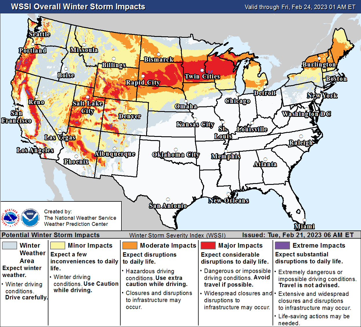
There are five levels that NOAA uses for potential winter storm impacts. Category five would put us in the "1991 Halloween Blizzard" zone.


MINNEAPOLIS — The National Oceanic and Atmospheric Administration is predicting that the impending snowstorm will hit "category five" in much of the Twin Cities metro area.
What does that mean, exactly?
There are five levels that NOAA uses to evaluate potential winter storm impacts.
Find out what's happening in Minneapolisfor free with the latest updates from Patch.
Category five, the highest level, states that residents should prepare for "substantial disruptions to daily life."
- Travel is not advised
- Expect extensive, widespread closures of major infrastructure
- Life-saving actions may be needed
Most of central Minnesota will be under category four conditions, which are still dangerous.
Find out what's happening in Minneapolisfor free with the latest updates from Patch.
But the Twin Cities metro could see category five, according to NOAA's interactive map.
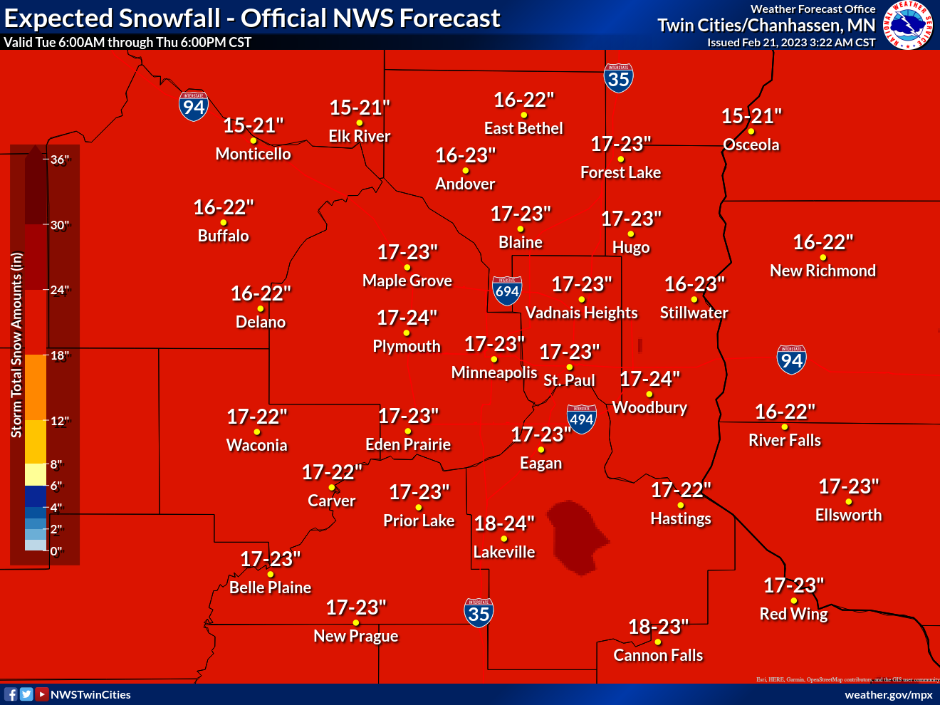
"Snow accumulations of 4 to 7 inches Tuesday and Tuesday night, followed by an additional 14 to 19 inches Wednesday afternoon into Thursday," the NWS says in its winter storm warning for the metro.
Winds gusting as high as 40 mph by Wednesday will create blizzard conditions. Temperatures are set to drop below 0 on Thursday night.
The metro could see 2 feet of snow when all is said and done this week. That puts us just below the much-discussed historic Halloween Blizzard of 1991.
"If you must travel, have a full tank of gas, a charged cell phone, and warm clothes or blankets with you. If you get stranded, stay with your vehicle," the NWS reminds motorists.
Here's the specific NWS forecast from the Minneapolis-St. Paul Airport:
Tuesday: Snow, mainly after 3pm. High near 20. Wind chill values as low as -12. West northwest wind 5 to 10 mph becoming east southeast in the afternoon. Chance of precipitation is 100%. Total daytime snow accumulation of 1 to 2 inches possible.
Tuesday Night: Snow. Low around 17. Blustery, with an east northeast wind 10 to 20 mph, with gusts as high as 25 mph. Chance of precipitation is 100%. New snow accumulation of 3 to 7 inches possible.
Wednesday: Snow. Patchy blowing snow after 10am. High near 22. Windy, with a northeast wind 20 to 30 mph, with gusts as high as 40 mph. Chance of precipitation is 90%. New snow accumulation of 1 to 3 inches possible.
Wednesday Night: Snow. The snow could be heavy at times. Widespread blowing snow, mainly after 7pm. Low around 12. Windy, with a northeast wind around 30 mph, with gusts as high as 45 mph. Chance of precipitation is 100%. New snow accumulation of 7 to 11 inches possible.
Thursday: Snow, mainly before 1pm. The snow could be heavy at times. Widespread blowing snow before 1pm, then patchy blowing snow after 3pm. High near 17. Blustery, with a north northwest wind 20 to 25 mph, with gusts as high as 40 mph. Chance of precipitation is 100%. New snow accumulation of 4 to 8 inches possible.
Thursday Night: A 30 percent chance of snow before 7pm. Patchy blowing snow before 8pm. Mostly cloudy, with a low around -7. Blustery, with a northwest wind 15 to 20 mph decreasing to 5 to 10 mph after midnight. Winds could gust as high as 30 mph.
Friday: Partly sunny, with a high near 11. West northwest wind around 5 mph becoming south in the afternoon.
Friday Night: A chance of snow between 7pm and 1am. Mostly cloudy, with a low around 3. South southeast wind 5 to 10 mph. Chance of precipitation is 30%.
Saturday: Mostly sunny, with a high near 24. South southwest wind 5 to 10 mph.
Saturday Night: Partly cloudy, with a low around 8. West wind around 10 mph.
Sunday: Sunny, with a high near 29. West southwest wind 5 to 10 mph.
Sunday Night: A slight chance of freezing rain. Partly cloudy, with a low around 16. South southwest wind around 10 mph becoming southeast after midnight. Chance of precipitation is 20%.
Monday: A chance of rain, snow, and freezing rain. Mostly sunny, with a high near 35. East southeast wind around 10 mph becoming north northwest in the afternoon. Chance of precipitation is 40%.
Get more local news delivered straight to your inbox. Sign up for free Patch newsletters and alerts.


