Weather
Thunderstorms, Sharp Temperature Drop To Hit Twin Cities Before Freezing Weekend
Storms could bring hail and gusty winds Friday before highs plunge into the 40s and overnight lows fall near freezing.

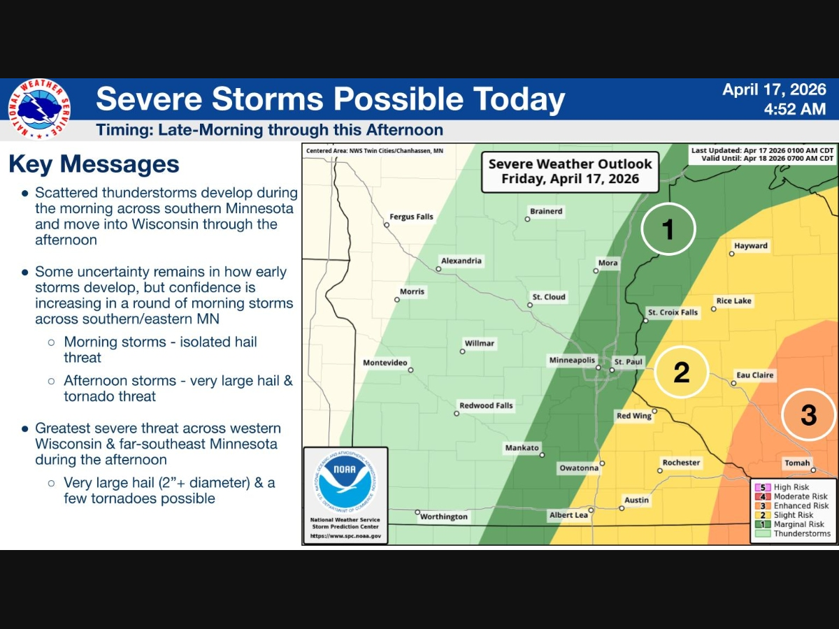

MINNEAPOLIS, MN — Dark skies over the Twin Cities Friday morning are the start of a stormy day that could bring strong to severe thunderstorms to the metro before a sharp temperature drop by evening.
The National Weather Service said a strong cold front is pushing across the region Friday. Forecasters expect a line of strong to severe thunderstorms to develop across eastern Minnesota late this morning into early this afternoon, then move quickly into western Wisconsin.
Large hail, damaging winds, and a tornado or two are possible, with the greatest severe threat expected to shift into western Wisconsin as the storms move east.
Find out what's happening in Minneapolisfor free with the latest updates from Patch.
Still, eastern Minnesota, including the Twin Cities, could see strong storms as the line develops and pushes through.
The forecast for Minneapolis-St. Paul calls for showers and possible thunderstorms mainly before 4 p.m., with a slight chance of additional storms after that. The chance of precipitation is 80 percent.
Find out what's happening in Minneapolisfor free with the latest updates from Patch.
Friday will also bring a dramatic cooldown. Temperatures are expected to fall to around 47 degrees by 5 p.m. after starting the day in the 60s. Winds will shift from the south to the northwest this afternoon, with gusts as high as 30 mph.
Rainfall amounts are expected to range from a tenth to a quarter of an inch in the Twin Cities, though thunderstorms could produce higher totals in some spots.
Once the storms clear out, much colder air will take over for the weekend. Friday night is expected to be blustery with a low around 30, followed by a high near 46 Saturday and around 50 Sunday.
Here's the full NWS forecast from the Minneapolis-St. Paul Airport:
Today
Showers and possibly a thunderstorm, mainly before 4pm, then a slight chance of showers and thunderstorms after 4pm. Temperature falling to around 47 by 5pm. Breezy, with a south wind 15 to 20 mph becoming northwest in the afternoon. Winds could gust as high as 30 mph. Chance of precipitation is 80%. New rainfall amounts between a tenth and quarter of an inch, except higher amounts possible in thunderstorms.
Tonight
Partly cloudy, with a low around 30. Blustery, with a northwest wind 15 to 20 mph, with gusts as high as 30 mph.
Saturday
Mostly sunny, with a high near 46. Breezy, with a west northwest wind 15 to 20 mph, with gusts as high as 30 mph.
Saturday Night
Partly cloudy, with a low around 32. West northwest wind 5 to 15 mph, with gusts as high as 25 mph.
Sunday
Sunny, with a high near 50. Northwest wind 5 to 10 mph.
Sunday Night
Clear, with a low around 30. North northwest wind 5 to 10 mph becoming southeast after midnight.
Monday
Sunny, with a high near 61. South southeast wind 5 to 15 mph.
Monday Night
Partly cloudy, with a low around 47. South wind around 10 mph.
Tuesday
Sunny, with a high near 70. West southwest wind around 5 mph becoming north northwest in the morning.
Tuesday Night
Clear, with a low around 46. North wind around 5 mph becoming east southeast after midnight.
Wednesday
Sunny, with a high near 76. South southeast wind 5 to 15 mph.
Wednesday Night
A 20 percent chance of showers. Partly cloudy, with a low around 57. Southeast wind around 10 mph.
Thursday
A 50 percent chance of showers and thunderstorms. Partly sunny, with a high near 76. South southeast wind 10 to 15 mph, with gusts as high as 25 mph.
Get more local news delivered straight to your inbox. Sign up for free Patch newsletters and alerts.


