Weather
Tornado Watch Includes Twin Cities Metro: MN Weather
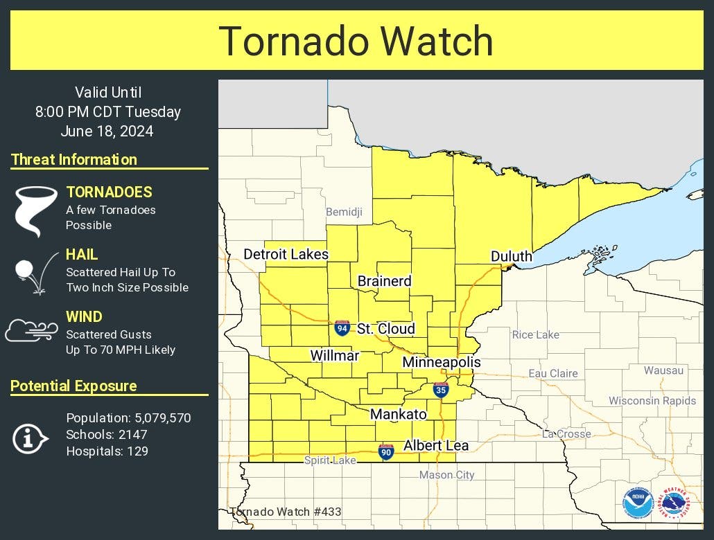
The National Weather Service has issued a tornado watch for most of Minnesota, including the Twin Cities metro area.

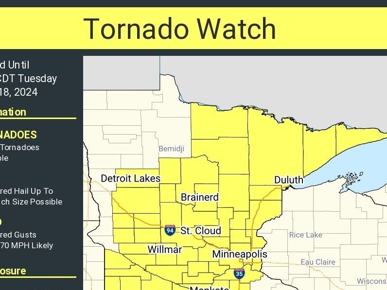
MINNEAPOLIS — The National Weather Service has issued a tornado watch for most of Minnesota, including the Twin Cities metro area.
"A few tornados possible" Tuesday, along with scattered, large hail and wind gusts up to 70 mph, the watch states.
Here's the full NWS forecast from the Minneapolis-St. Paul Airport:
Find out what's happening in Minneapolisfor free with the latest updates from Patch.
This Afternoon: A 40 percent chance of showers and thunderstorms, mainly after 3pm. Mostly cloudy, with a high near 86. Breezy, with a south wind around 20 mph, with gusts as high as 40 mph.
Tonight: Showers and thunderstorms, mainly before midnight. Low around 63. Breezy, with a south southwest wind 10 to 20 mph becoming west northwest after midnight. Winds could gust as high as 30 mph. Chance of precipitation is 80%. New rainfall amounts between a half and three quarters of an inch possible.
Find out what's happening in Minneapolisfor free with the latest updates from Patch.
Wednesday: A slight chance of showers and thunderstorms before 10am, then a slight chance of showers between 10am and 1pm. Mostly cloudy, with a high near 73. Northwest wind 5 to 10 mph. Chance of precipitation is 20%.
Wednesday Night: A chance of showers, with thunderstorms also possible after 4am. Mostly cloudy, with a low around 61. North northeast wind around 5 mph. Chance of precipitation is 40%.
Thursday: A 40 percent chance of showers and thunderstorms. Mostly cloudy, with a high near 76. East northeast wind 5 to 10 mph.
Thursday Night: A chance of showers and thunderstorms, then showers likely and possibly a thunderstorm after 1am. Mostly cloudy, with a low around 66. East wind 5 to 10 mph. Chance of precipitation is 60%. New rainfall amounts between a quarter and half of an inch possible.
Friday: Showers and possibly a thunderstorm. High near 81. South southeast wind 5 to 10 mph. Chance of precipitation is 80%. New rainfall amounts between a half and three quarters of an inch possible.
Friday Night: Showers and thunderstorms likely, then showers and possibly a thunderstorm after 1am. Low around 70. South southeast wind around 10 mph. Chance of precipitation is 80%.
Saturday: Showers and possibly a thunderstorm. High near 82. South wind 10 to 15 mph. Chance of precipitation is 80%.
Saturday Night: A 40 percent chance of showers and thunderstorms, mainly before 1am. Mostly cloudy, with a low around 65. West northwest wind 10 to 15 mph.
Sunday: A 20 percent chance of showers. Mostly sunny, with a high near 80. West northwest wind 10 to 15 mph, with gusts as high as 25 mph.
Sunday Night: Mostly clear, with a low around 63. Northwest wind 5 to 15 mph.
Monday: Sunny, with a high near 84. West wind 5 to 10 mph becoming south southeast in the afternoon.
Get more local news delivered straight to your inbox. Sign up for free Patch newsletters and alerts.


