Weather
Tornado Watch Likely As Dangerous Storms Approach Twin Cities: MN Weather
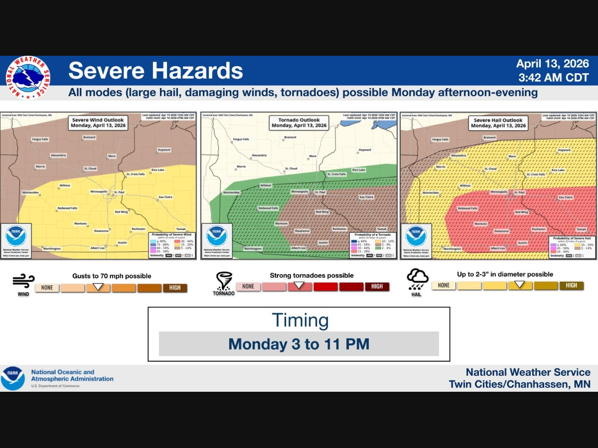
Severe storms capable of tornadoes, large hail and damaging winds are expected to develop between 3 p.m. and 6 p.m.

MINNEAPOLIS, MN — A tornado watch is likely this afternoon as dangerous storms begin to develop across southern Minnesota and move toward the Twin Cities.
The National Weather Service says this will be the first significant severe weather event of the season, with conditions becoming increasingly favorable for strong to severe thunderstorms later Monday.
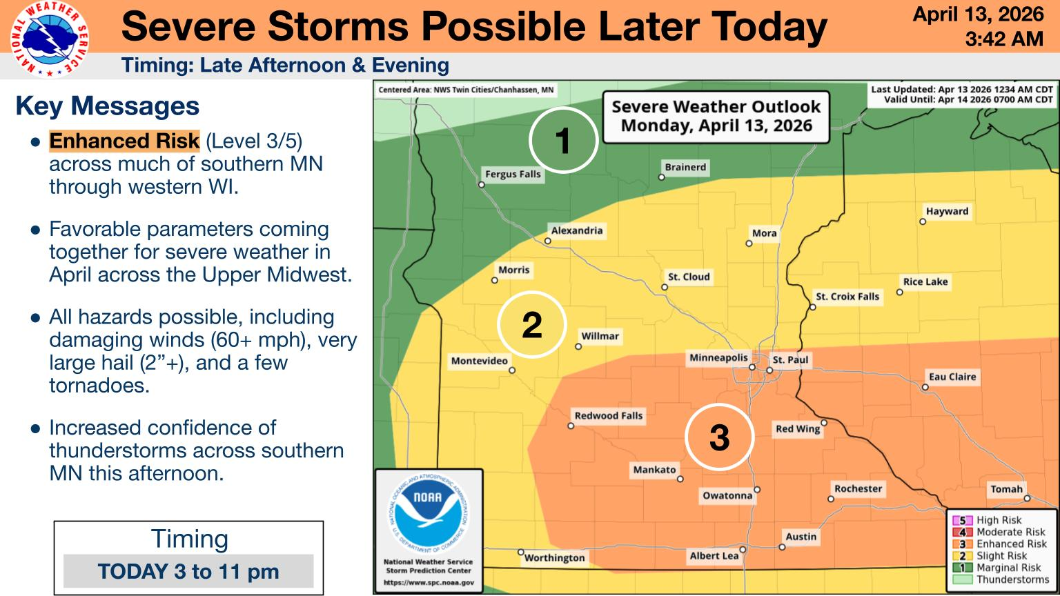
Forecasters say storms are expected to develop between 3 p.m. and 6 p.m. along a stalled warm front across southern Minnesota. Initial storms are expected to form as supercells, which can quickly become dangerous and produce all types of severe weather, before merging into a line and tracking east-northeast into Wisconsin.
Find out what's happening in Minneapolisfor free with the latest updates from Patch.
The Storm Prediction Center said there is an 80 percent chance a tornado watch will be issued over parts of southeast Minnesota into central Wisconsin in the coming hours as the severe threat ramps up.
All severe hazards are possible, including very large hail of 2 inches or more, damaging winds exceeding 70 mph and a few tornadoes. Forecasters say some tornadoes could be strong, particularly with storms that track along the warm front.
Find out what's happening in Minneapolisfor free with the latest updates from Patch.
While the highest risk is expected south of the Twin Cities, storms may move toward the metro through the late afternoon and evening hours.
Storm chances are expected to increase rapidly after 3 p.m., with the most active period during the evening. The severe threat is expected to decrease after about 10 p.m., though some storms could linger into the night.
In the Twin Cities, Monday will be partly sunny with a high near 73 degrees before storms move in later in the day. Showers and thunderstorms are likely Monday night, with some storms still capable of being severe and rainfall totals of up to a half-inch possible.
Conditions are expected to quiet down on Tuesday, with mostly cloudy skies and highs in the upper 60s.
Here's the full NWS forecast from the Minneapolis-St. Paul Airport:
This Afternoon
A chance of showers and thunderstorms, then showers likely and possibly a thunderstorm after 5pm. Some of the storms could be severe. Partly sunny, with a high near 73. Northeast wind around 10 mph becoming east southeast. Chance of precipitation is 60%. New rainfall amounts between a tenth and quarter of an inch, except higher amounts possible in thunderstorms.
Tonight
Showers and thunderstorms likely, mainly before midnight. Some of the storms could be severe. Mostly cloudy, with a low around 51. Northeast wind 5 to 10 mph. Chance of precipitation is 70%. New rainfall amounts between a quarter and half of an inch possible.
Tuesday
Mostly cloudy, with a high near 69. North wind around 5 mph becoming west in the morning.
Tuesday Night
A 20 percent chance of showers before 10pm. Partly cloudy, with a low around 46. North wind 5 to 10 mph.
Wednesday
A 30 percent chance of showers after 1pm. Mostly sunny, with a high near 68. East northeast wind around 5 mph.
Wednesday Night
A chance of showers before 10pm, then a chance of showers and thunderstorms between 10pm and 1am, then a chance of showers after 1am. Mostly cloudy, with a low around 50. North northeast wind 5 to 10 mph. Chance of precipitation is 50%. New rainfall amounts between a tenth and quarter of an inch, except higher amounts possible in thunderstorms.
Thursday
A 30 percent chance of showers, mainly before 1pm. Mostly sunny, with a high near 72. North wind 5 to 10 mph becoming southeast in the afternoon.
Thursday Night
Mostly clear, with a low around 56. Southeast wind 5 to 10 mph.
Friday
A slight chance of showers, then showers likely and possibly a thunderstorm after 1pm. Partly sunny, with a high near 75. Southeast wind 10 to 15 mph, with gusts as high as 30 mph. Chance of precipitation is 70%.
Friday Night
Rain showers likely before 4am, then a chance of rain and snow showers. Some thunder is also possible. Mostly cloudy, with a low around 35. Southwest wind around 15 mph becoming northwest after midnight. Winds could gust as high as 30 mph. Chance of precipitation is 60%.
Saturday
A chance of rain and snow showers. Partly sunny, with a high near 47. West northwest wind around 15 mph, with gusts as high as 30 mph. Chance of precipitation is 40%.
Saturday Night
A 20 percent chance of snow showers. Mostly cloudy, with a low around 28. West northwest wind 10 to 15 mph, with gusts as high as 30 mph.
Sunday
Sunny, with a high near 51. West northwest wind around 10 mph.
Get more local news delivered straight to your inbox. Sign up for free Patch newsletters and alerts.