Weather
Tornadoes, Large Hail Possible On Tuesday, NWS Warns: MN Weather
The storms have the potential of producing "tornadoes, damaging winds, and large hail," the National Weather Service said.


MINNEAPOLIS — Minnesotans should be prepared for severe weather Tuesday.
"Numerous strong to severe thunderstorms are forecasted for Tuesday afternoon/evening across southeastern Minnesota and western WI with the potential of producing few tornadoes, damaging winds, and large hail," the National Weather Service said.
"Although some storms are possible in the morning, the strongest threat for severe weather is Tuesday evening."
Find out what's happening in Minneapolisfor free with the latest updates from Patch.
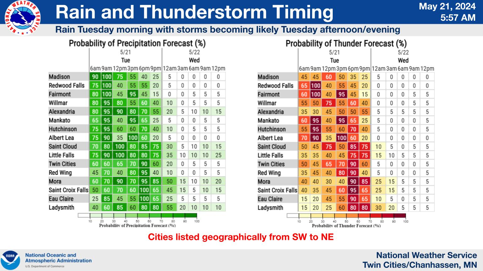
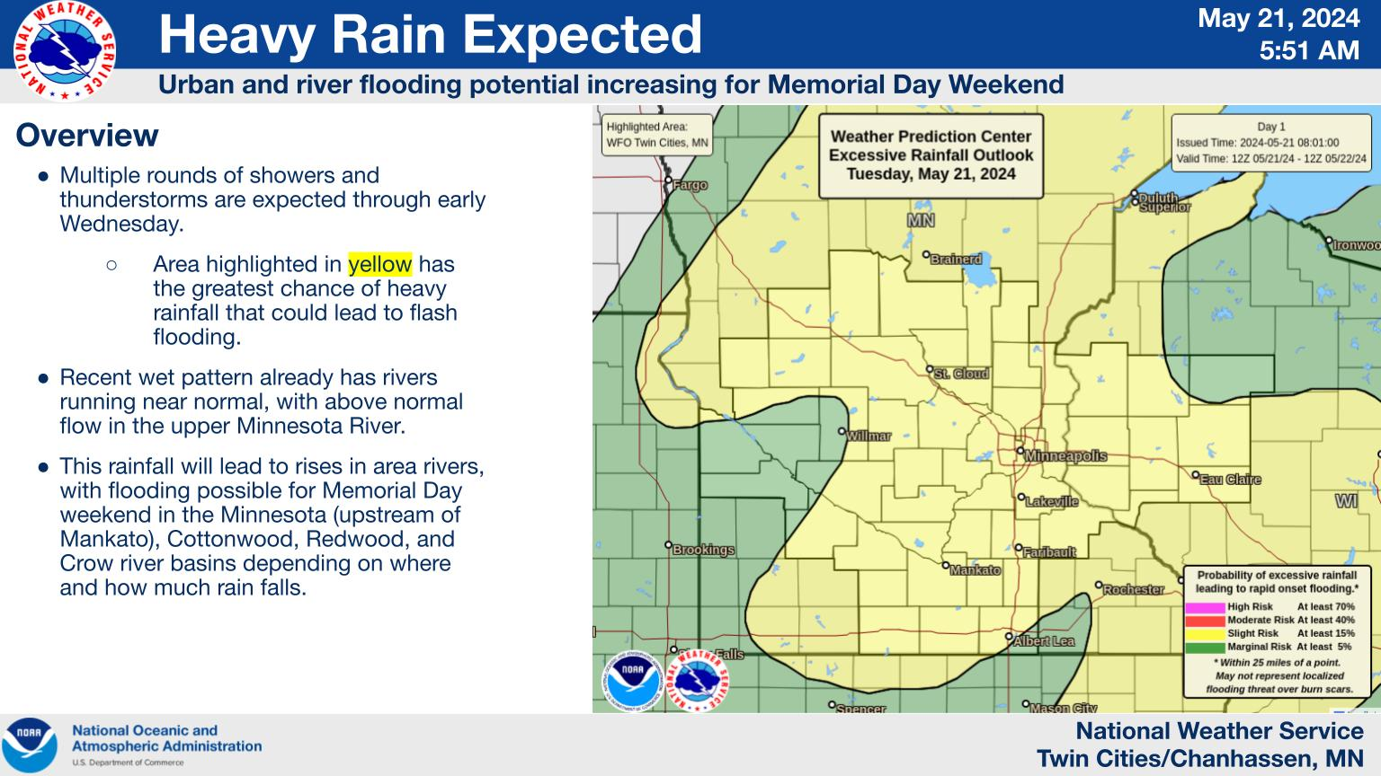
Two rounds of heavy rain are expected Tuesday into Wednesday, bringing risks of flash flooding.
With river levels normal and above normal, additional rainfall will also increase the possibility of river flooding during the Memorial Day weekend. The Minnesota River is especially high-risk.
Find out what's happening in Minneapolisfor free with the latest updates from Patch.
Here's the specific NWS forecast from the Minneapolis-St. Paul Airport:
Tuesday: Showers and thunderstorms. Some of the storms could be severe and produce heavy rainfall. High near 74. Breezy, with a southeast wind 10 to 20 mph, with gusts as high as 30 mph. Chance of precipitation is 100%. New rainfall amounts between 1 and 2 inches possible.
Tuesday Night: Showers and thunderstorms before midnight, then a chance of showers between midnight and 1am. Some of the storms could be severe and produce heavy rainfall. Low around 53. Breezy, with a southwest wind 10 to 15 mph becoming west northwest 15 to 20 mph after midnight. Winds could gust as high as 35 mph. Chance of precipitation is 80%. New precipitation amounts between a quarter and half of an inch possible.
Wednesday: A slight chance of showers between 1pm and 4pm. Sunny, with a high near 72. Breezy, with a west wind 15 to 20 mph, with gusts as high as 30 mph. Chance of precipitation is 20%.
Wednesday Night: Mostly clear, with a low around 54. Southwest wind 5 to 15 mph.
Thursday: Sunny, with a high near 77. West southwest wind 5 to 10 mph.
Thursday Night: A slight chance of showers and thunderstorms before 10pm, then a slight chance of showers between 10pm and 1am, then a chance of showers and thunderstorms after 1am. Partly cloudy, with a low around 58. East southeast wind around 10 mph. Chance of precipitation is 30%.
Friday: A chance of showers and thunderstorms, then showers likely and possibly a thunderstorm after 1pm. Mostly cloudy, with a high near 72. East southeast wind 10 to 15 mph becoming southwest in the afternoon. Chance of precipitation is 60%. New rainfall amounts between a tenth and quarter of an inch, except higher amounts possible in thunderstorms.
Friday Night: A chance of showers and thunderstorms before 1am, then a slight chance of showers. Partly cloudy, with a low around 50. West northwest wind 10 to 15 mph. Chance of precipitation is 40%.
Saturday: Mostly sunny, with a high near 68. West northwest wind around 10 mph.
Saturday Night: Partly cloudy, with a low around 52. Northwest wind around 5 mph becoming east after midnight.
Sunday: A 20 percent chance of showers. Mostly sunny, with a high near 74. East southeast wind 5 to 10 mph.
Sunday Night: A 30 percent chance of showers and thunderstorms. Partly cloudy, with a low around 55. East wind 5 to 10 mph.
Memorial Day: A 40 percent chance of showers and thunderstorms. Mostly sunny, with a high near 72. East southeast wind 5 to 10 mph becoming west in the afternoon.
Get more local news delivered straight to your inbox. Sign up for free Patch newsletters and alerts.


