Weather
Twin Cities Storm Shift: What Changed Since Yesterday
Forecasters say the system is trending warmer and wetter, with less snow and more rain and mixed precipitation expected.

TWIN CITIES, MN — The spring storm moving through Minnesota is shifting, with forecasters now expecting less snow and more rain across the Twin Cities than earlier projections suggested.
The National Weather Service says recent trends have nudged the system north, changing how precipitation is falling across the region.
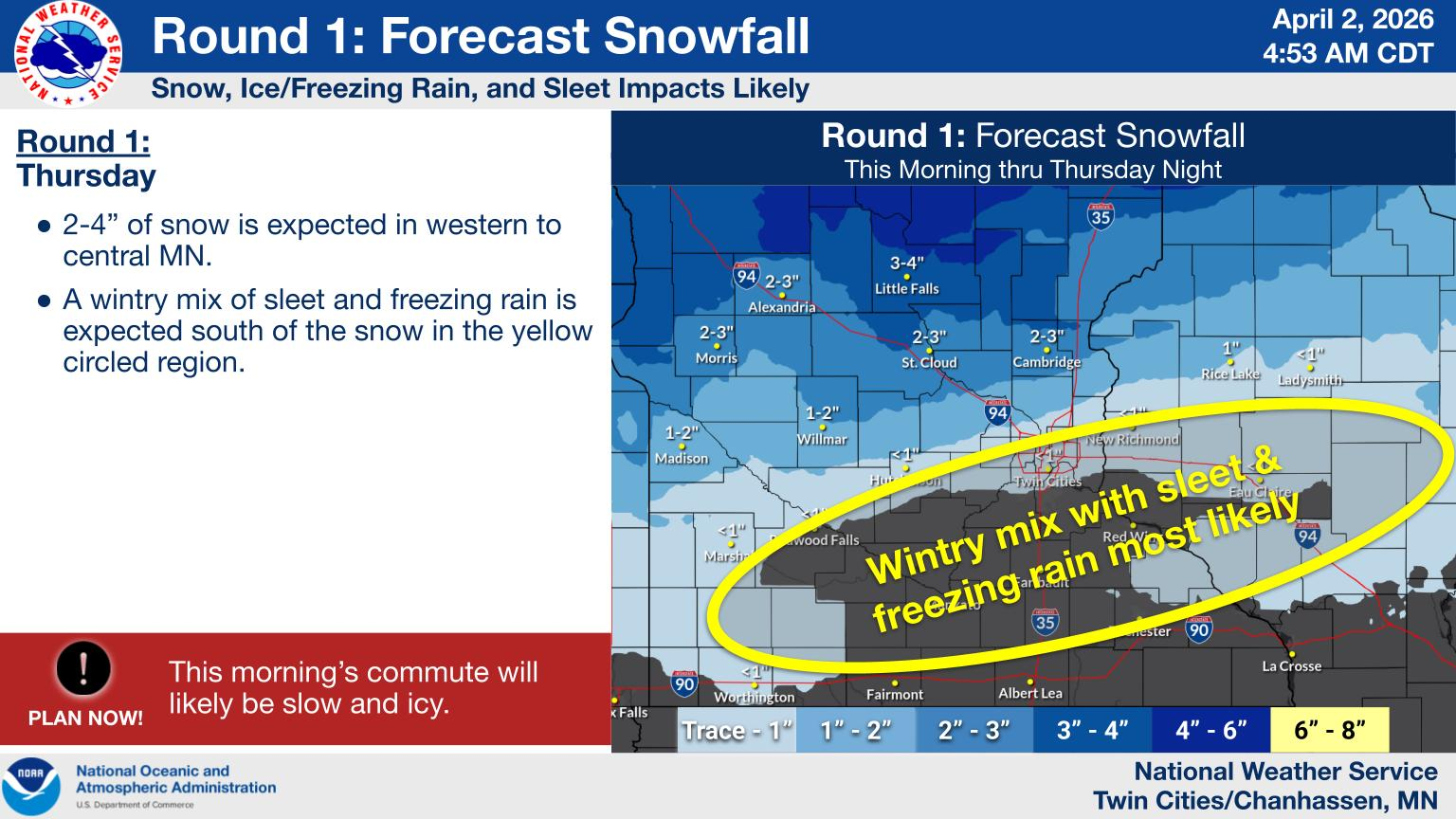
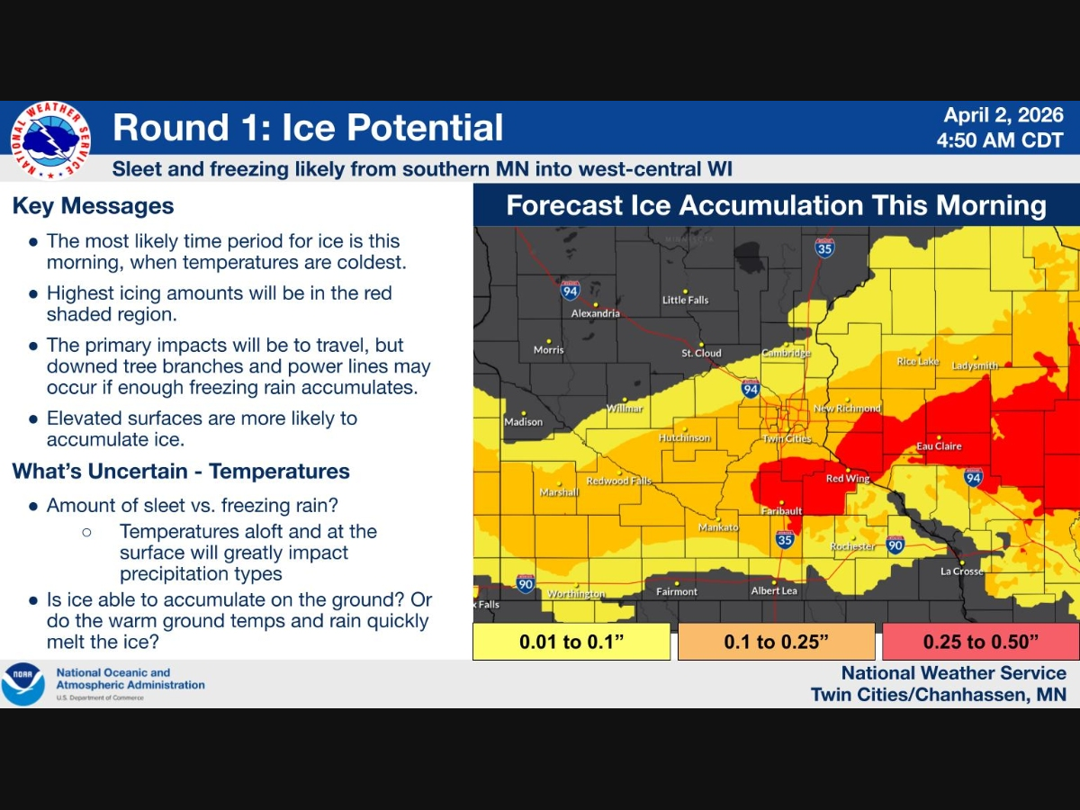
Instead of a more snow-heavy setup, the Twin Cities is now largely in a transition zone, where rain, sleet and freezing rain are more likely, especially during key periods of the storm.
Find out what's happening in Minneapolisfor free with the latest updates from Patch.
That shift was already evident Thursday morning, as freezing rain and sleet created slick roads and a difficult commute across the metro.
Meanwhile, areas farther west and north are still expected to pick up more snow, with totals in the 2 to 4 inch range in parts of central Minnesota.
Find out what's happening in Minneapolisfor free with the latest updates from Patch.
The changes don’t stop there.
A second round of the system is expected Friday into Saturday, bringing more rain, possible thunderstorms, and another mix of precipitation types as temperatures fluctuate.
Forecasters caution that small changes in the track of the storm could still have a big impact on who sees rain versus snow, meaning the forecast could continue to evolve.
Here's the full NWS forecast from the Minneapolis-St. Paul Airport:
This Afternoon: Showers. High near 36. Northeast wind around 15 mph. Chance of precipitation is 100%. New precipitation amounts between a tenth and quarter of an inch possible.
Tonight: Rain showers likely, possibly mixed with snow showers and sleet before 8pm, then a chance of rain showers and sleet between 8pm and 9pm. Cloudy, with a low around 28. Northwest wind 5 to 10 mph. Chance of precipitation is 60%. Little or no snow and sleet accumulation expected.
Friday: Showers likely and possibly a thunderstorm before 2pm, then a chance of showers and thunderstorms between 2pm and 4pm, then showers likely and possibly a thunderstorm after 4pm. Mostly cloudy, with a high near 42. North wind 5 to 15 mph becoming east in the afternoon. Chance of precipitation is 60%. New rainfall amounts between a tenth and quarter of an inch, except higher amounts possible in thunderstorms.
Friday Night: Showers and possibly a thunderstorm before 11pm, then rain, mainly after 11pm. Low around 34. East northeast wind 10 to 15 mph. Chance of precipitation is 100%. New precipitation amounts between a quarter and half of an inch possible.
Saturday: Rain likely before 10am, then snow likely, possibly mixed with rain. Cloudy, with a high near 39. Breezy, with a west wind 10 to 20 mph, with gusts as high as 30 mph. Chance of precipitation is 60%. Little or no snow accumulation expected.
Saturday Night: Mostly cloudy, with a low around 29. West northwest wind 10 to 15 mph, with gusts as high as 25 mph.
Sunday: Sunny, with a high near 47. West northwest wind 10 to 15 mph.
Sunday Night: Partly cloudy, with a low around 32. West northwest wind around 10 mph.
Monday: Partly sunny, with a high near 44. Northwest wind 10 to 15 mph.
Monday Night: Partly cloudy, with a low around 25. North northwest wind 5 to 10 mph becoming northeast after midnight.
Tuesday: Mostly sunny, with a high near 48. East wind 5 to 15 mph becoming south southeast in the afternoon.
Tuesday Night: A 30 percent chance of showers. Partly cloudy, with a low around 38. South southeast wind 10 to 15 mph.
Wednesday: A 30 percent chance of showers. Partly sunny, with a high near 62. South wind around 15 mph, with gusts as high as 30 mph.
Get more local news delivered straight to your inbox. Sign up for free Patch newsletters and alerts.


