Community Corner
Buckets of Rain Heading Our Way
The National Weather Service has issued a hazardous weather outlook for Northfield and much of Minnesota for the next few days.
Buckets of rain are heading our way
The National Weather Service has issued a hazardous weather outlook for Northfield and much of Minnesota for the next few days. Several inches of rain could fall before Tuesday.
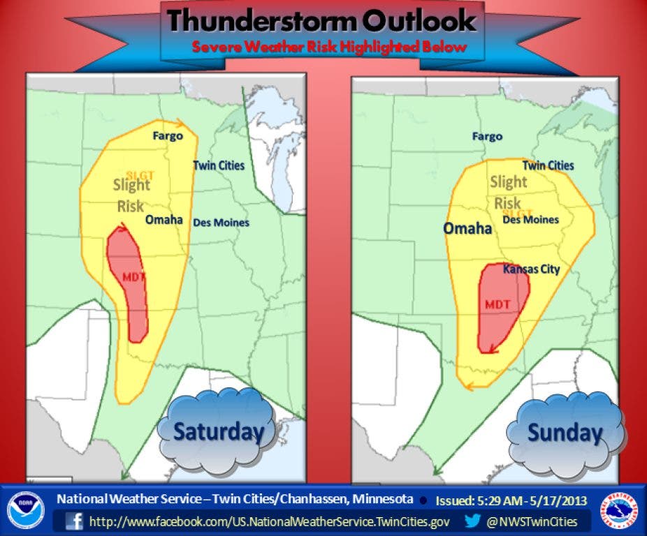
Hail and wind could accompany the rain on Sunday, says the weather service.
Find out what's happening in Northfieldfor free with the latest updates from Patch.
Here is the text of the outlook:
THIS HAZARDOUS WEATHER OUTLOOK IS FOR PORTIONS OF CENTRAL AND SOUTHERN MINNESOTA... AND WEST CENTRAL WISCONSIN.
Find out what's happening in Northfieldfor free with the latest updates from Patch.
.DAY ONE...TODAY AND TONIGHT
SCATTERED THUNDERSTORMS CAN BE EXPECTED TODAY...MAINLY ALONG AND NORTH OF INTERSTATE 94. DURING THE DAYTIME HOURS...SEVERE THUNDERSTORMS ARE NOT EXPECTED. HOWEVER...SOME THUNDERSTORMS WILL BE CAPABLE OF PRODUCING SMALL HAIL...GUSTY WINDS...HEAVY DOWNPOURS AND FREQUENT LIGHTNING. GOING INTO TONIGHT...COVERAGE AND INTENSITY OF THUNDERSTORMS WILL INCREASE FROM WEST TO EAST ACROSS MINNESOTA INTO WESTERN WISCONSIN. A SLIGHT RISK OF SEVERE THUNDERSTORMS EXISTS GENERALLY ALONG AND WEST OF A LINE FROM LITTLE FALLS TO HUTCHINSON TO FAIRMONT...WHERE ISOLATED THUNDERSTORMS WILL BE CAPABLE OF PRODUCING LARGE HAIL AND DAMAGING WINDS. TIMING OF SEVERE THUNDERSTORMS APPEARS TO BE LATE THIS EVENING THROUGH THE OVERNIGHT HOURS.
.DAYS TWO THROUGH SEVEN...SUNDAY THROUGH FRIDAY
SEVERAL ROUNDS OF THUNDERSTORMS ARE EXPECTED THROUGH TUESDAY. MUCH OF THE AREA IS OUTLOOKED FOR A SLIGHT RISK FOR SEVERE THUNDERSTORMS...GENERALLY SOUTH OF A LINE FROM...BENSON...ZIMMERMAN TO NEAR EAU CLAIRE. TIMING OF THE THREAT FOR SEVERE WEATHER WOULD COME SUNDAY AFTERNOON INTO SUNDAY NIGHT. LARGE HAIL AND DAMAGING WINDS ARE THE MOST LIKELY THREATS.
HEAVY RAINFALL IS ALSO LIKELY IN THE STRONGER STORMS. RAINFALL AMOUNTS COULD EXCEED 4 INCHES BY TUESDAY. THESE AMOUNTS MAY CAUSE SIGNIFICANT RISES IN RIVERS AND STREAMS...AND MAY ALSO CAUSE URBAN FLOODING.
Here is the forecast for the coming days, according to the weather service:
• This Afternoon—Partly sunny, with a high near 82. South southeast wind 10 to 15 mph.
• Tonight—Showers and thunderstorms likely, mainly after 4am. Mostly cloudy, with a low around 65. South southeast wind 10 to 15 mph. Chance of precipitation is 60%. New rainfall amounts of less than a tenth of an inch, except higher amounts possible in thunderstorms.
• Sunday—Showers and thunderstorms likely. Mostly cloudy, with a high near 81. South southeast wind 10 to 15 mph. Chance of precipitation is 70%. New rainfall amounts between a quarter and half of an inch possible.
• Sunday Night—Showers and thunderstorms. Low around 64. Southeast wind around 10 mph. Chance of precipitation is 80%. New rainfall amounts between three quarters and one inch possible.
• Monday—Showers and thunderstorms likely. Mostly cloudy, with a high near 75. South wind 10 to 15 mph. Chance of precipitation is 70%. New rainfall amounts between a quarter and half of an inch possible.
• Monday Night—A 50 percent chance of showers and thunderstorms. Mostly cloudy, with a low around 56. South wind 5 to 10 mph. New rainfall amounts between a tenth and quarter of an inch, except higher amounts possible in thunderstorms.
• Tuesday—Showers and thunderstorms likely. Mostly cloudy, with a high near 68. Southeast wind around 5 mph. Chance of precipitation is 70%
• Tuesday Night—Showers and thunderstorms likely. Cloudy, with a low around 51. East northeast wind around 5 mph. Chance of precipitation is 60%.