Weather
Tornado Watch Issued For Twin Cities Metro; Rotation Reported
Forecasters say a few tornadoes are possible Wednesday evening as severe storms with rotation move through parts of Minnesota.


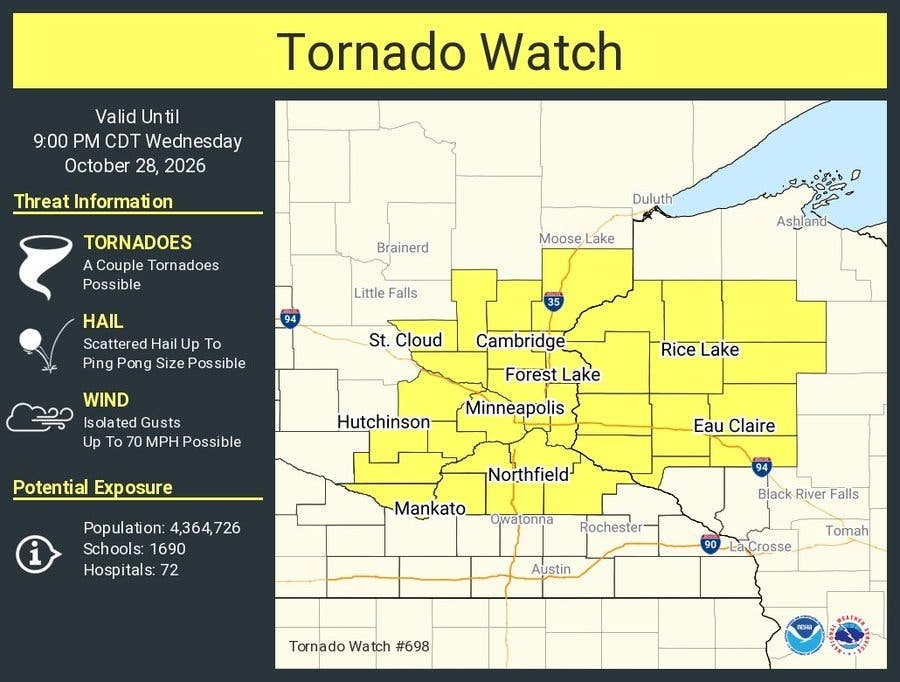
TWIN CITIES, MN — A tornado watch is in effect until 9 p.m. Wednesday for much of the Twin Cities metro and parts of central and southern Minnesota as severe thunderstorms move through the region on an unusually warm October day.
The Storm Prediction Center issued Tornado Watch 698 at 3:40 p.m. It covers 21 Minnesota counties: Anoka, Benton, Carver, Chisago, Dakota, Goodhue, Hennepin, Isanti, Kanabec, Le Sueur, McLeod, Mille Lacs, Nicollet, Pine, Ramsey, Rice, Scott, Sherburne, Sibley, Washington and Wright.
As of 4:30 p.m., three severe thunderstorm warnings were in effect, and there had been several reports of rotation, the National Weather Service in the Twin Cities said in an update on X.
Find out what's happening in Saint Paulfor free with the latest updates from Patch.
A tornado watch means conditions are favorable for tornadoes to develop. A tornado warning means a tornado has been spotted or indicated on radar, and people in the warned area should take shelter right away.
East-central Minnesota, including the Twin Cities metro, and far western Wisconsin are under a slight risk of severe weather, Level 2 on a 5-point scale. The rest of central and southern Minnesota and western Wisconsin is under a marginal risk, Level 1 of 5.
Find out what's happening in Saint Paulfor free with the latest updates from Patch.
Forecasters said large hail, damaging winds and a few tornadoes are all possible. Storms began in western Minnesota early in the afternoon and are expected to continue into the evening for eastern Minnesota and western Wisconsin.
In the metro, the weather service forecast calls for showers and possibly a thunderstorm before 8 p.m., then a chance of showers and storms between 8 and 9 p.m. Some of those storms could be severe. It was 70 degrees at Minneapolis-St. Paul International Airport just before 4 p.m., with a south wind around 10 mph.
In a hazardous weather outlook issued Wednesday afternoon, the weather service said storm spotters may need to be activated through early this evening.
Cooler, drier air arrives behind the storms. Overnight lows will drop to around 42 degrees, and Thursday will be sunny with a high near 56. Friday is expected to be mostly sunny with a high near 57.
Chances for rain return over the weekend, with a 30 percent chance of showers Saturday, according to the forecast. Temperatures are expected to stay above normal, and more rain chances are in the forecast for next week.
Residents in the watch area should know where they would shelter if a warning is issued. The weather service recommends a basement or an interior room on the lowest floor, away from windows. More tornado safety tips are available from the NWS.
Get more local news delivered straight to your inbox. Sign up for free Patch newsletters and alerts.