Weather
3-5 Inches Of Snow Tuesday Before Temperatures Nosedive: MN Weather
An incoming winter storm is expected to dump "plowable" snow in the Twin Cities metro area this week, the National Weather Service said.


TWIN CITIES, MN — Following the Thanksgiving week heatwave, a significant winter storm is on track to dump "plowable" snow in the Twin Cities metro area early this week.
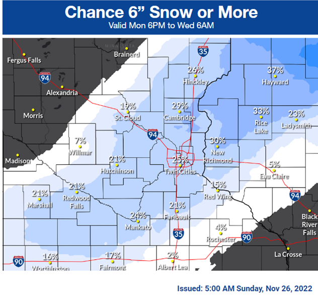
Between 3 to 5 inches of snow is forecasted to fall on Tuesday, according to the National Weather Service. The heaviest band of snow is expected to hit areas just northeast of the metro.
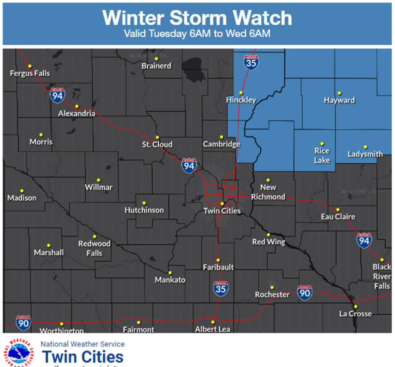
A winter storm watch has already been issued for a part of that region:
Find out what's happening in Southwest Minneapolisfor free with the latest updates from Patch.
"Heaviest amounts could still shift, so keep an eye on the forecast," the NWS said.
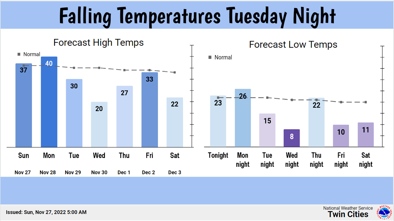
After the snowstorm Tuesday, temperatures are expected to plummet overnight. Wednesday currently has a low of 9 degrees near the airport.
Find out what's happening in Southwest Minneapolisfor free with the latest updates from Patch.
Here's the full NWS forecast from the Minneapolis-St. Paul Airport:
Sunday: Mostly cloudy, then gradually becoming sunny, with a high near 38. North wind 5 to 10 mph.
Sunday Night: Increasing clouds, with a low around 26. North northwest wind 5 to 10 mph becoming south southeast in the evening.
Monday: Mostly cloudy, with a high near 41. South southeast wind 10 to 15 mph.
Monday Night: A 30 percent chance of snow after midnight. Mostly cloudy, with a low around 30. South wind 5 to 10 mph becoming north after midnight.
Tuesday: Snow. High near 34. North northeast wind 5 to 15 mph. Chance of precipitation is 80%. New snow accumulation of 3 to 5 inches possible.
Tuesday Night: A 50 percent chance of snow before midnight. Mostly cloudy, with a low around 20. West northwest wind around 15 mph, with gusts as high as 25 mph. New snow accumulation of less than one inch possible.
Wednesday: Partly sunny, with a high near 23. Blustery, with a west northwest wind 15 to 20 mph, with gusts as high as 30 mph.
Wednesday Night: Mostly clear, with a low around 9. West northwest wind 5 to 15 mph becoming southwest after midnight.
Thursday: Mostly sunny, with a high near 29. South southeast wind 5 to 15 mph.
Thursday Night: Mostly cloudy, with a low around 24. South wind 10 to 15 mph.
Friday: A 20 percent chance of snow. Mostly cloudy, with a high near 35. South wind 10 to 15 mph becoming west in the afternoon.
Friday Night: Mostly cloudy, with a low around 16. West northwest wind 10 to 15 mph.
Saturday: Mostly sunny, with a high near 26. West wind around 10 mph
Get more local news delivered straight to your inbox. Sign up for free Patch newsletters and alerts.


