Weather
'Timing Will Be Unfortunate,' NWS Says Of Twin Cities' Snowstorm
The snowstorm is almost certain to impact the morning and evening rush hours on Tuesday, so prepare for a slow commute.


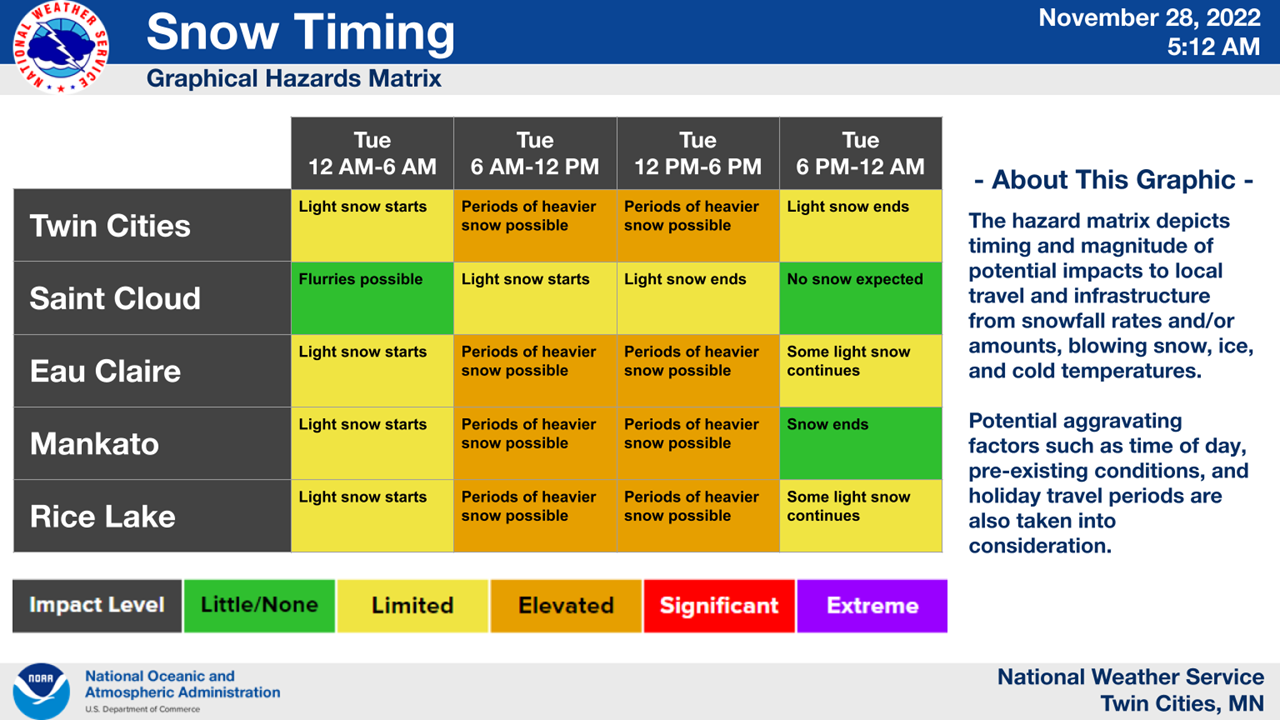
MINNEAPOLIS — A winter storm is still on track to dump snow onto the Twin Cities metro area Tuesday. Between 3 and 5 inches of snow is projected to fall, according to the latest National Weather Service forecast from the Minneapolis-St. Paul Airport.
The chance of precipitation is 100 percent on Tuesday for most of the Minneapolis area.
"Most areas will see accumulating snow, with the exception of far western Minnesota," the NWS said. "Cold air will fill in behind the system, bringing the coldest temps so far this season."
Find out what's happening in Southwest Minneapolisfor free with the latest updates from Patch.
The snowstorm is almost certain to impact both morning and evening rush hour commutes.
"Timing will be unfortunate, affecting both the morning and evening commute in the Twin Cities," the NWS notes.
Find out what's happening in Southwest Minneapolisfor free with the latest updates from Patch.
Here's the full NWS forecast from the Minneapolis-St. Paul Airport:
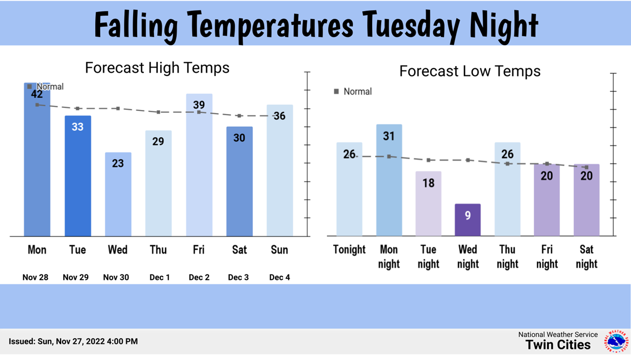
Monday: Mostly cloudy, with a high near 42. South southeast wind 5 to 15 mph, with gusts as high as 25 mph.
Monday Night: A 40 percent chance of snow, mainly after 4am. Mostly cloudy, with a low around 30. South wind around 5 mph becoming calm in the evening.
Tuesday: Snow. Temperature falling to around 28 by 5pm. Light north northeast wind becoming north 5 to 10 mph in the morning. Chance of precipitation is 100%. New snow accumulation of 3 to 5 inches possible.
Tuesday Night: Snow likely, mainly before 10pm. Mostly cloudy, with a low around 19. West northwest wind around 10 mph. Chance of precipitation is 60%. New snow accumulation of less than a half inch possible.
Wednesday: Partly sunny, with a high near 23. West northwest wind around 15 mph, with gusts as high as 30 mph.
Wednesday Night: Mostly clear, with a low around 10. West northwest wind 10 to 15 mph becoming light west after midnight. Winds could gust as high as 25 mph.
Thursday: Mostly sunny, with a high near 30. Light and variable wind becoming south southeast 10 to 15 mph in the morning.
Thursday Night: Partly cloudy, with a low around 25. South wind around 10 mph.
Friday: Partly sunny, with a high near 40. South wind around 10 mph.
Friday Night: Partly cloudy, with a low around 17. West northwest wind 5 to 10 mph.
Saturday: Mostly sunny, with a high near 24. West northwest wind around 10 mph.
Saturday Night: Partly cloudy, with a low around 15. West wind around 5 mph becoming south after midnight.
Sunday: Mostly sunny, with a high near 34. South wind 5 to 10 mph.
Get more local news delivered straight to your inbox. Sign up for free Patch newsletters and alerts.


