Weather
Up To 8 Inches Of Snow Now Possible Tuesday: MN Weather Storm Update
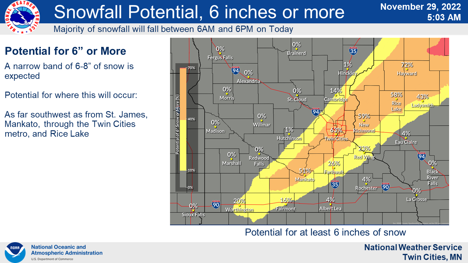
The winter storm could drop 5 to 8 inches of snow, the National Weather Service said in its winter storm warning for the region.


TWIN CITIES, MN — As predicted, a significant snowstorm began pounding the Twin Cities metro area Tuesday morning. Snow total forecasts have remained steady or grown in some parts of the region.
"Widespread plowable snow expected today with a narrower band of heavier snow," the National Weather Service said. "Around 6 inches most likely in the heavier band, but locally higher totals possible."

A winter storm warning is in effect for the metro through 9 p.m. Counties included in the warning are Hennepin, Ramsey, Washington, Carver, Scott, and Dakota.
Find out what's happening in Southwest Minneapolisfor free with the latest updates from Patch.
Across the border, Wisconsin's Polk, Barron, and St. Croix County are also under a warning.
"Total snow accumulations of 5 to 8 inches," the warning from the NWS reads."Travel could be very difficult. The hazardous conditions could impact the morning and evening commute."
Find out what's happening in Southwest Minneapolisfor free with the latest updates from Patch.
NWS adds that "If you must travel, keep an extra flashlight, food, and water in your vehicle in case of an emergency."
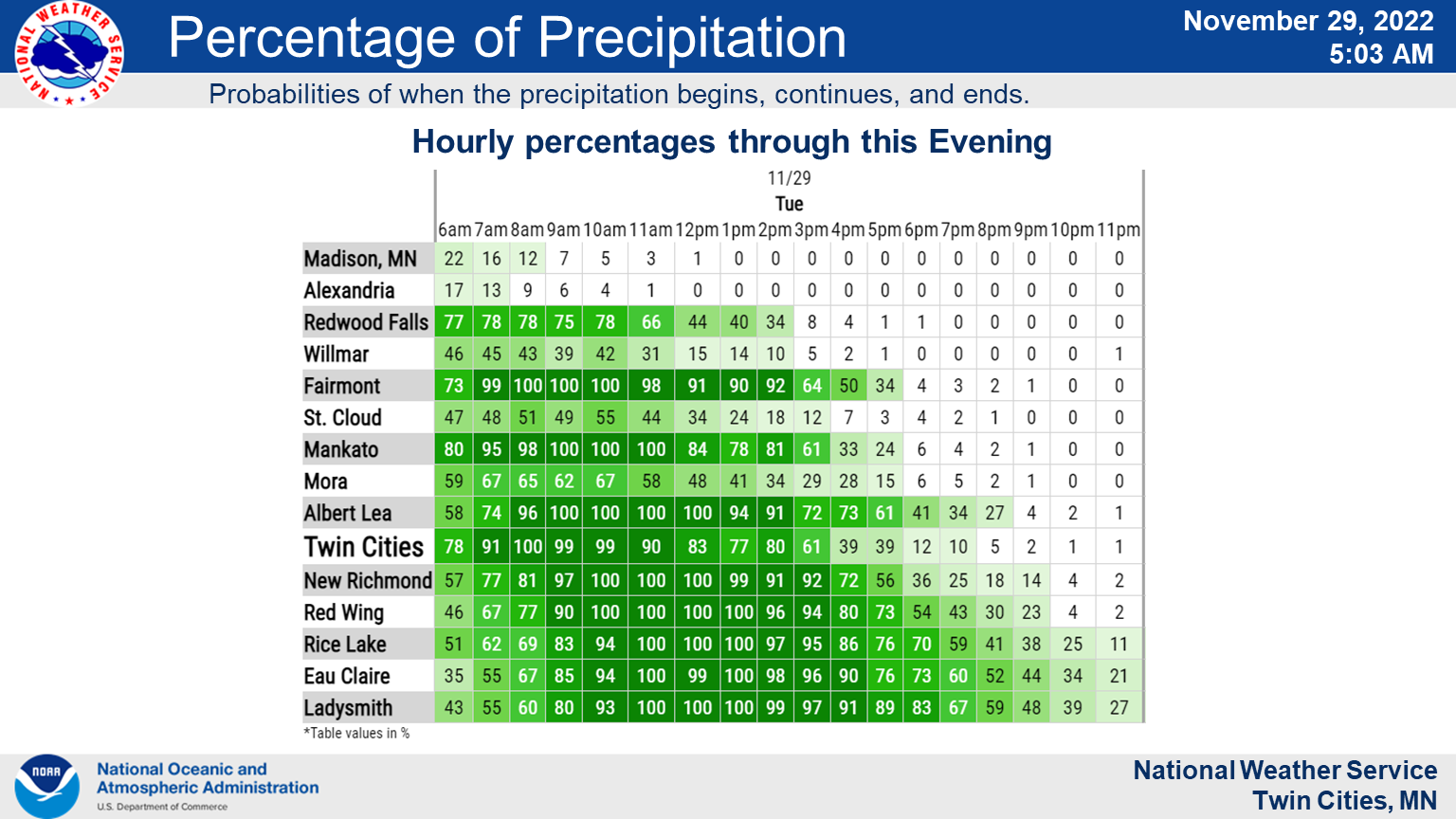
The snow began around 5 a.m. and will wrap up Tuesday afternoon and evening:
Here's the full NWS forecast from the Minneapolis-St. Paul Airport:
Tuesday: Snow, mainly before 4pm. The snow could be heavy at times. Temperature falling to around 26 by 3pm. North wind 10 to 15 mph. Chance of precipitation is 100%. Total daytime snow accumulation of 6 to 10 inches possible.
Tuesday Night: A 20 percent chance of snow before 7pm. Patchy blowing snow after 2am. Mostly cloudy, with a low around 17. Breezy, with a west wind 15 to 20 mph, with gusts as high as 30 mph.
Wednesday: Patchy blowing snow before 5pm. Partly sunny, with a steady temperature around 20. Breezy, with a west wind 15 to 25 mph, with gusts as high as 35 mph.
Wednesday Night: Mostly clear, with a low around 9. West wind 10 to 15 mph becoming west southwest 5 to 10 mph after midnight.
Thursday: Mostly sunny, with a high near 32. South southeast wind 5 to 15 mph, with gusts as high as 30 mph.
Thursday Night: Mostly cloudy, with a low around 28. South wind 10 to 15 mph, with gusts as high as 25 mph.
Friday: Partly sunny, with a high near 41. South wind around 10 mph.
Friday Night: Mostly cloudy, with a low around 15. West northwest wind 10 to 15 mph, with gusts as high as 30 mph.
Saturday: Mostly sunny, with a high near 23. West northwest wind 10 to 15 mph, with gusts as high as 25 mph.
Saturday Night: Partly cloudy, with a low around 13. South wind 5 to 10 mph.
Sunday: Mostly sunny, with a high near 33. South southwest wind around 10 mph.
Sunday Night: Mostly cloudy, with a low around 18. South southwest wind around 10 mph becoming north northwest after midnight.
Monday: A 20 percent chance of snow. Partly sunny, with a high near 26. North northwest wind around 10 mph.
Get more local news delivered straight to your inbox. Sign up for free Patch newsletters and alerts.


