Weather
'Dangerously Hot' Weather: Heat Advisory Issued For Hennepin County
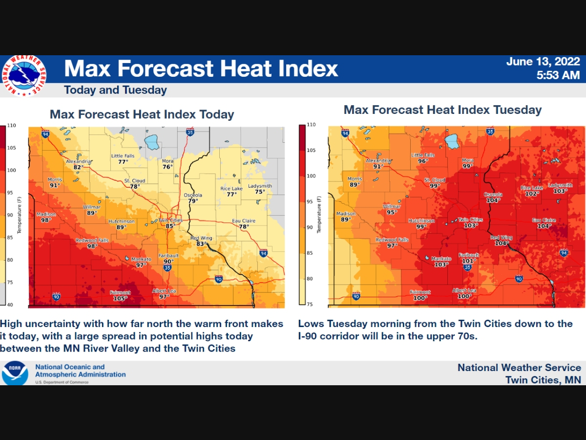
Residents in the Twin Cities metro area should be prepared for dangerously hot conditions with heat index values up to 103 degrees.

HENNEPIN COUNTY, MN — The National Weather Service has issued an excessive heat warning for Hennepin Hennepin, Anoka, Ramsey, Washington, Carver, Scott, and Dakota County. The warning will be in effect from 11 a.m. to 8 p.m. Tuesday.
Residents in the Twin Cities metro area should be prepared for dangerously hot conditions, with a high near 98 degrees and a heat index value of up to 103 degrees.
The NWS provided the following tips to stay safe during the heatwave:
Find out what's happening in Southwest Minneapolisfor free with the latest updates from Patch.
- Drink plenty of fluids, stay in an air-conditioned room, stay out of the sun, and check up on relatives and neighbors
- Young children and pets should never be left unattended in vehicles under any circumstances
- Take extra precautions if you work or spend time outside
- When possible reschedule strenuous activities to early morning or evening
- Know the signs and symptoms of heat exhaustion and heat stroke
- Wear lightweight and loose-fitting clothing when possible
- To reduce risk during outdoor work, the Occupational Safety and Health Administration recommends scheduling frequent rest breaks in shaded or air-conditioned environments
- Anyone overcome by heat should be moved to a cool and shaded location.
- Heat stroke is an emergency! Call 911.
Here’s the full NWS forecast from the Minneapolis-St. Paul International Airport:
Monday: Showers and thunderstorms, mainly before 9am. Some of the storms could produce heavy rainfall. High near 82. Southeast wind 10 to 15 mph. Chance of precipitation is 90%. New precipitation amounts between a quarter and half of an inch possible.
Find out what's happening in Southwest Minneapolisfor free with the latest updates from Patch.
Monday Night: Mostly cloudy, with a low around 76. East southeast wind 10 to 15 mph.
Tuesday: Mostly sunny and hot, with a high near 98. Heat index values as high as 103. Breezy, with a south southeast wind 10 to 20 mph becoming southwest in the afternoon. Winds could gust as high as 30 mph.
Tuesday Night: A 40 percent chance of showers and thunderstorms. Partly cloudy, with a low around 66. West wind 5 to 15 mph.
Wednesday: Showers likely before 10am, then showers likely and possibly a thunderstorm between 10am and 1pm, then a chance of showers and thunderstorms after 1pm. Partly sunny, with a high near 80. West southwest wind 5 to 10 mph. Chance of precipitation is 60%. New rainfall amounts between a quarter and half of an inch possible.
Wednesday Night: Mostly clear, with a low around 64. West southwest wind 5 to 10 mph.
Thursday: Sunny, with a high near 84. Breezy, with a west wind 10 to 20 mph, with gusts as high as 35 mph.
Thursday Night: Clear, with a low around 63. Breezy, with a west northwest wind 15 to 20 mph decreasing to 5 to 10 mph after midnight. Winds could gust as high as 30 mph.
Friday: Sunny, with a high near 83. North northwest wind 5 to 10 mph becoming northeast in the afternoon.
Friday Night: Mostly clear, with a low around 64. East wind 5 to 10 mph.
Saturday: Sunny, with a high near 89. South wind 10 to 15 mph.
Saturday Night: Mostly clear, with a low around 71. South wind 10 to 15 mph.
Sunday: Sunny and hot, with a high near 93. South wind 10 to 15 mph, with gusts as high as 25 mph.
Get more local news delivered straight to your inbox. Sign up for free Patch newsletters and alerts.


